Labels

Aberdeenshire (21) Angus (4) antiquities (87) Argyll and Bute (35) Arran (7) art (37) birds (231) bridge (9) Caithness (12) Carmarthenshire (5) castle (165) Ceredigion (9) Channel Islands (13) Cheshire West and Cheshire (1) City and County of Swansea (1) City of Bristol (2) City of Edinburgh (4) Conwy (8) Cornwall (74) County Antrim (19) County Down (23) County Durham (3) County Londonderry (4) Cumbria (19) Denbighshire (2) Devon (48) diving (9) Dorset (18) Dumfries and Galloway (22) Dundee City (2) East Lothian (6) East Sussex (16) East Yorkshire (6) English Riviera (3) Essex (17) Fife (19) Flintshire (1) food (13) fossils (14) gardens (28) Ghosts (35) Glamorgan (1) Gower (7) Guernsey (4) Gwent (1) Gwynedd (19) Hampshire (13) Highland (72) Inner Hebrides (42) Inverclyde (5) Islay (8) Isle of Anglesey (14) Isle Of Man (7) Isle Of Wight (10) Isles of Scilly (3) Jersey (7) Kent (22) Lancashire (8) Lewis and Harris (7) lighthouse (62) Lincolnshire (8) Merseyside (8) Mid Glamorgan (1) mining (23) Moray (10) Mull (8) Norfolk (21) North Ayrshire (13) North Yorkshire (12) Northern Ireland (45) Northumberland (17) Orkney (10) Outer Hebrides (14) Pembrokeshire (27) pubs (47) Ross and Cromarty (20) Scotland (300) Scottish Borders (3) Shetland (14) shipwrecks (42) Skye (12) smuggling (48) Somerset (9) South Ayrshire (6) South Glamorgan (5) South Gloucestershire (1) Suffolk (18) surfing (84) Sutherland (16) Tyne and Wear (8) Wales (93) wartime (75) webcams (232) West Dunbartonshire (3) West Glamorgan (9) West Sussex (9)

Friday, 30 December 2011

PETERHEAD

Peterhead brought little joy to James Francis Edward Stuart, son of the deposed James II of England, and commonly referred to as "The Old Pretender" for his designs on the throne, when he arrived there from France on 22 December 1715, the year of "The Fifteen" Jacobite Rising which was aimed at putting James on the throne. He arrived stricken with seasickness and fever and in a state of misery over the fact that his treasure ship had been lost en route. To add to his woes, there was a rather feeble show of support waiting there for him. He didn't hang about: in February the following year he boarded a ship at Montrose for his return to France.

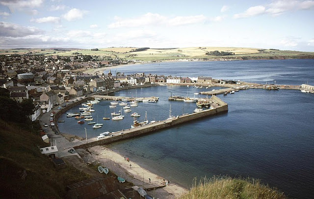
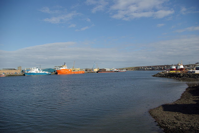
Peterhead has the distinction of being the most easterly point of Scotland, as well as the most populous town in Aberdeenshire; Aberdeen itself comes under a different municipal area. Fishing is the name of the game here, operating out of a complex, multi-section harbour, although further back in time sealing and whaling played a part in the local economy. The town is often referred to as "The Blue Toon", probably because of the colour of the socks and jumpers traditionally favoured by the fishermen. Peterhead's tourist attractions include the Lido, which is actually a sandy beach within the town's outer harbour. Peterhead Old Parish Church, or "Muckle Kirk", is 200 years old and has a graceful spire. Each summer, the town holds its Scottish Week, a chance to showcase the best produce and entertainment the locality can offer.

Map of the area.

Peterhead Bay - geograph.org.uk - 159768. Photo by Richard Slessor, via Wikimedia Commons.


Wednesday, 28 December 2011

BODDAM

Boddam, a granite fishing village which almost vies with Peterhead for the title of most easterly place in Scotland, lies above a harbour with big, solid concrete walls. The village is dominated by the red and white lighthouse on nearby Buchan Ness, completed in 1827 by Robert Stevenson, the grandfather of writer Robert Louis Stevenson. A bridge connects the lighthouse to the mainland. A public footpath from the harbour leads to the golden Sandford Bay, where lovers of sea bass can try their luck with these fish, as they are attracted to the area by the warm water brought about by the proximity of Peterhead Power Station. The Bay is also a great place for a walk, perhaps with a dog in tow, who will no doubt become all the more excitable due to the large rabbit population on this shore. Wildlife enthusiasts can view the large numbers of seals on the rocks outside the harbour, as well as a variety of seabirds. There used to be an RAF station nearby called RAF Buchan station, but this was closed down after 52 years. Now there is a bronze statue in Boddam of an airman which was unveiled in 2009 to commemorate the station. Sadly, the year after the unveiling, the local press reported that the statue had been vandalised by so-called "freedom fighters".

Map of the area.

Boddam. Photo by Mike Pennington, via Wikimedia Commons.


Monday, 26 December 2011

CRUDEN BAY

This beautiful bay, overlooked by the haunting ruins of the 16th century Slains Castle, was frequented by the novelist and creator of Dracula Bram Stoker, in fact it is thought that Slains Castle was the inspiration for Dracula, which was written in 1895. Two years later, the railway reached this area, opening the area up to tourism. A magnificent hotel was built, and golf courses were laid out, bordering on the fabulous sandy beach. A 1931 report of a serious fire at the railway station described it as having "commodious refreshment rooms, booking office, entrance hall and waiting rooms". The railway and hotel have gone now, but other hotels have been built, and the Cruden Bay Golf Club remains, billing itself as "a unique and unforgettable experience". As for the castle, it was announced in 2007 that the castle was to be converted into apartments, but this project is currently in the balance. Anyone wanting to visit the castle is warned to take care because of the dangerous surroundings, in fact as if to reinforce the dangers, it was reported earlier this month that a pensioner had gone missing in the area of the path from Cruden Bay to Slains Castle.

In 1914 Cruden Bay was the starting point for the first ever flight across the North Sea, when the Norwegian pilot Tryggve Gran flew from here to Stavanger. There is a memorial to him in the main street. St James Church dates from the 18th century, but there is a font which probably came from an earlier church built by Malcolm II in 1012, after a battle between the Scots and the Danes.

Map of the area.

View of Cruden Bay from the estuary. Photo by Mikey Shepherd, via Wikimedia Commons.


Sunday, 25 December 2011

COLLIESTON

The village of Collieston, 20 miles north of Aberdeen, was once a thriving fishing village, with a good dose of smuggling thrown in for good measure. The 19th century pier stands as a reminder of past fishing activities. Sadly, the fishing declined partly as a result of the effect of the pier on the harbour, causing an accumulation of sand there. To the south of the village is the Forvie National Nature Reserve where the remains of a 12th century church lie half-buried among the sand dunes, whose inhabitants include the eider ducks so prevalent in this north-east corner of the country. Stories about smuggling and other tales of Collieston over the ages can be found on the excellent Collieston website.

Map of the area.

Lobster Boats at Collieston. - geograph.org.uk - 117085. Photo by Colin Smith, via Wikimedia Commons.


Thursday, 22 December 2011

ABERDEEN

From Newtonhill, the approach to Aberdeen is marked by a series of small villages: Downies, Portlethen, which has become a residential area for commuters to Aberdeen, and Findon (aka Finnan), home of a variety of smoked fish called Finnan Haddie.

James Boswell and Samuel Johnson, who we last met slagging off a waiter at their inn in Montrose (see 8 December) had a much more positive experience on their arrival at Aberdeen, where the Lord Provost invited them to the Town Hall and bestowed on Johnson the freedom of the city. They also visited the English Chapel, where "the congregation was numerous and splendid".

The modern-day Aberdeen is dominated by the North Sea oil industry, as can be seen from the many oil-platform supply vessels crowding the harbour. The harbour's other functions include fishing, fish-processing and general trading, and it is also a departure point for ferries to Shetland and the Orkneys. Aberdeen's sandy shore has an 18-hole golf course called the Kings Links running alongside it. The city's museums include a Maritime Museum, housed in Provost Ross's House on the historic street known as Shiprow, an art gallery and Provost Skene's House, which resembles a castle more than a mere house. Aberdeen is often referred to as the Granite City, since granite features heavily in the city's impressive architecture, for example in the Marischal College, founded in 1593, which forms part of the University and has a museum which tells the story of the college's history. In fact, this learned city has two universities: the University of Aberdeen and Robert Gordon University, though the latter has only had university status since 1992.

The part of the city known as Old Aberdeen was once a separate Burgh and from the late Middle Ages was an important political, ecclesiastical and cultural centre. Many of the old buildings in this part of the city form part of a conservation area. King's College, which used to be a separate university, is located here. Its chapel dates from the 15th century, and has an impressive tower topped with an "imperial crown", a recreation of the original 17th century crown, which was lost during a storm. St Machar's Cathedral is also in Old Aberdeen; in spite of its name it is strictly speaking a "high kirk", since it is no longer the seat of a bishop.

For a list of events in Aberdeen, see here.

Webcam view of Aberdeen Beach.

Map of the area.

Old Marine Operations Centre, Aberdeen - geograph.org.uk - 1958623. Photo by Greig Ritchie, via Wikimedia Commons.


Tuesday, 20 December 2011

MUCHALLS

It's been a while since I last told a ghost story, so as we come to the darkest part of the year it seems like a good time for another one. The story behind the Green Lady of Muchalls Castle is a very sad one so get the tissues ready. The area was rife with smuggling in the old days, and the castle had a tunnel leading down to a cave on Muchalls Beach which was used to store spirits and wine brought in by smugglers. A young woman from the castle was having a bit of a romance with one of the smugglers, and one day she ran down to the tunnel to greet his return, forgetting that it was high tide and the tunnel was prone to flooding at high tide. The poor lady drowned before she had a chance to keep her tryst, and her ghost is said to haunt the castle's drawing room, where she parades up and down with a brush in her hand, getting herself ready for the rendezvous that would never be.

There is much more to Muchalls Castle's past than smuggling. One of the most notable events in its history was in 1638 when a gathering of Covenanters (Scottish Presbyterians) took place here in the run up to the English Civil War. During Victorian times, Muchalls was a popular health resort, with a golf course and a railway station, now gone although the line still runs through here. One of its most distinguished visitors was Charles Dickens, who sang its praises as a beautiful place to visit. Robert Burns was moved to describe the area as "a good deal romantic", and not without reason, as the coast around here is a spectacular mix of soaring cliffs formed from pre-Cambrian rock, sea stacks and rugged headlands such as Grim Brigs and Doonie Point.

A short distance up the coast from Muchalls is the larger settlement of Newtonhill, a clifftop fishing village with cottages and fishermen's huts. The Burn of Elsick flows into the North Sea here, and there is much good walking in the area, such as circular walk which takes in a plank bridge over the Burn. The Braehead is a good place for walkers to rest and enjoy the views of the bay or watch out for the wildlife of the area which, as well as a variety of sea birds, includes occasional sightings of seals, dolphins or even whales.

Map of the area.

Felsite rocks Muchalls - geograph.org.uk - 375747. Photo by Russell Lett, via Wikimedia Commons.


Sunday, 18 December 2011

STONEHAVEN

With Hogmanay coming up soon, Stonehaven is gearing up for its annual Stonehaven Fireballs ceremony. This festival is a spectacular and colourful way of seeing in the New Year which attracts thousands of spectators including a fair few 'expats' home for the holidays visiting friends and relatives. The main event is a parade of people along the High Street in the Old Town swinging fireballs around their heads.

The harbour of the old town of Stonehaven is shared by yachts and fishing boats, while the town itself centres around its 19th century Market Buildings. In 1748 a group of ministers imprisoned in the town secretly baptised the children of fishermen's wives, who brought their charges to the ministers' cell windows. This and other fascinating stories are told in the Tolbooth Museum, set in Stonehaven's oldest building, built in the 16th century as a storehouse for George the 5th Earl Marischal while Dunnottar Castle was being rebuilt. To the north of the town is the old royal burgh of Cowie, another fishing area, and a row of cottages calld Boatie Row. From here a path leads over the cliff to the ruined 13th century St Mary of the Storms Church, from where there are lovely sea views.

For a list of events in Stonehaven, follow this link.

Map of the area.

Stonehaven Harbour - geograph.org.uk - 2240451. Photo by Russel Wills, via Wikimedia Commons.


Saturday, 17 December 2011

DUNNOTTAR CASTLE

The red cliffs that make such a magnificent contribution to the setting of villages such as Catterline present an even more impressive sight on reaching the approach towards Stonehaven, as the romantic ruins of Dunnottar Castle come into view. The castle must have been a highly effective fortress in its day, standing as it does on an impregnable rock separated from the mainland by a deep ravine. However, this does not mean that it cannot be visited, as there is a tunnel entrance leading up to the top level where the surviving buildings are sited. The castle's origins lie in the arrival of St Ninian in the 5th century, when he chose the site for one of a chain of churches. Over the years that followed, it saw plenty of action. In the Middle Ages William Wallace - aka Mel Gibson - led his Scottish Army in the defeat of the English, subsequently imprisoning and burning them in the castle church. In 1650, during an eight-month siege by Oliver Cromwell's army, a small garrison at the castle manfully held out and saved the Scottish Crown Jewels from destruction by allowing them to be smuggled out. The castle was seized by the Government following the 1715 Jacobite Rising because one of the participants in the Rising was the last Earl Marischal, the owner of the castle at the time. Two centuries of neglect followed until 1925, when the 1st Viscountess Cowdray began restoration work. So we have the Viscountess to thank for the fact that this incredible place can be revisited here in the 21st century.

Map of the area.

Dunnottar Castle - geograph.org.uk - 1550283. Photo by Alan Findlay, via Wikimedia Commons.


Wednesday, 14 December 2011

CATTERLINE AND CRAWTON

A glance at the Catterline website reveals that the Christmas celebrations are in full swing in this little village on the east coast of Scotland. The local pub is holding a Christmas party for the residents on Friday, to which they are invited to wear black tie and best frocks, while two days later the church is putting on music and words accompanied by mulled wine and mince pies. Wish you were there? I do.

Catterline is perched on top of a cliff. It has a long history of fishing and smuggling activities, and acquired a pier in 1810 for the protection of the fishing vessels based there. Neighbouring Crawton also had a thriving fishing industry, but the boats moved from there to safer facilities at Stonehaven. There is a path linking the two villages. Also, from Crawton, birdwatchers should take the path to nearby Fowlsheugh RSPB Reserve, where huge numbers of kittiwakes, fulmars, razorbills, guillemots and other birds share this prime bit of sea-bird real estate.

Christianity arrived in the area around the year 400 when St Ninian came and converted the Picts, but the present incarnation of Catterline's church, St Philip's, only dates from 1848, though somehow it looks older. Its interior, with its whitewashed walls, has a bright, airy feel to it. Like many little coastal communities around the country, the village has proved a magnet for artists, and belongs to that select club with a "school" named after them. The "Catterline School" of artists, which came about during the 1950s, included Joan Eardley, who owned a cottage in the village, and whose works include "The Wave", painted outside during stormy weather in February 1961: that shows dedication!

Webcam view of Catterline Bay.

Map of the area.

View of Catterline Pier and Catterline Bay - geograph.org.uk - 1493683. Photo by Alan Morrison, via Wikimedia Commons.


Monday, 12 December 2011

GOURDON AND INVERBERVIE

Just to the south of Inverbervie, the village of Gourdon has a long history of fishing possibly stretching back to Neolithic times. The harbour was no more than a gap in the rocks until 1819 when Thomas Telford built a proper harbour, later expanded. Inverbervie was granted the status of Royal Burgh by King David II when he and his Queen were forced to land here in 1341 during stormy weather on their way back from France, and the locals looked after them in their hour of need. The town takes its name from the River Bervie, which flows into the North Sea here. Fishing used to be the mainstay of the economy until a flax mill was opened, leading to a thriving textiles industry. One of the town's more notable sons was Hercules Linton, who designed the Cutty Sark tea clipper. He is remembered through a commemorative garden with a monument consisting of a full-size replica of the ship's figurehead. Linton is buried in the local church graveyard. Hallgreen Castle, overlooking the seafront, is now a private home offering tourist accommodation.

Map of the area.

Bervie Bay, Inverbervie - geograph.org.uk - 2139158. Photo by Dona Robbins, via Wikimedia Commons.


Sunday, 11 December 2011

ST CYRUS AND JOHNSHAVEN

The small community of St Cyrus, just north of Montrose and at the southern extreme of the Aberdeenshire coast, is best known for its beautiful 3-mile beach and its National Nature Reserve, where in summer a host of butterflies can be found flitting among the flora here, which includes the purple clustered bellflower. Hovering above this lovely scene are the peregrine falcons which stalk the skies, ready to home in on their prey.

In the 18th century, Johnshaven was one of the most important fishing communities in Scotland. However, many of the young men at that time were being whisked away by the navy press gangs, leaving a shortage of manpower. Johnshaven's role as a fishing village is celebrated each year with a Fish Festival, held during the first half of August. The exact date depends on the tides. One of the big draws nowadays is the lobster fishing. The unfortunate lobsters can often be seen in water tanks by the harbourside, where they are kept before being exported to the Continent. Nearby, the Mill of Benholm is a restored, working water-powered meal mill which can be visited in summer. Also at Benholm is Benholm Church, on a site dating from at least the 13th century.

Map of the area.

Johnshaven Harbour - geograph.org.uk - 1832561. Photo by JThomas, via Wikimedia Commons.


Thursday, 8 December 2011

MONTROSE

On August 20 1773 the famous 18th century travelling companions James Boswell and Dr Samuel Johnson fetched up in Montrose during a tour of Scotland. They were none too impressed with their lodgings there, an inn where according to Boswell a waiter "put a lump of sugar with his fingers into Dr. Johnson's lemonade, for which he called him "rascal!"." However, the following morning they started to see the town in a better light, visiting the town hall "where is a good dancing room, and other rooms for tea-drinking". [i]

The Montrose Boswell and Johnson visited in 1773 would have been a very different place to the present-day Montrose. There would have been no Montrose Academy in those days, with its handsome golden dome - the Academy was established in 1815. Neither would they have been able to visit the Montrose Museum, opened in 1842 and housed in an elegant building in the neo-classical style with Ionic columns on either side of the doorway. The present-day Montrose Parish Church would not yet have been built; instead Boswell and Johnson would have looked upon its predecessor, a 16th century church and bell tower, extended in 1643. They would also have been denied the chance to visit the Montrose Air Station Heritage Centre, on the site of Britain's first military air station, which was established in 1912.

However, the pair would have had the chance to enjoy a round of golf, since the first recorded instance of golf being played in Montrose was in 1562, or possibly even earlier. They also would have been able to indulge in a bit of bird-watching on the tidal waters of Montrose Basin, although they would have had to return in winter to observe the many bird species who arrive at the Basin at this time of year, including greylag and pink-footed geese. The modern-day Montrose combines industry and tourism, with a port and North Sea oil supply base existing alongside a sandy beach, two golf courses, and the seafront with the Traill Pavilion.  For art fans there is the William Lamb Studio.

[i] From Everybody's Boswell, edited by Frank Morley.

Live streaming webcam view, provided by Montrose Port Authority.

Map of the area.

Montrose Port by Nick. Photo by Nick Birse, via Wikimedia Commons.


Tuesday, 6 December 2011

LUNAN BAY

Walking along the beautiful, unspoilt beach of this bay, voted the best in Scotland in the year 2000, it is hard to imagine the events of around a millennium ago. In the year 1010 Lunan Bay witnessed a massive invasion of Vikings who were on their way to sack Dundee - an abortive mission as it turned out, thanks to be best efforts of Malcolm II and his fearsome Scottish army at Barry Sands (Carnoustie). It was probably the Viking invasions which led to the construction of "rubeum castrum", or Red Castle, in the 12th century, so called because it was built from red sandstone. William The Lion used it as a residence for his hunting expeditions. In the 16th century, the castle bore witness to scenes worthy of a modern-day soap opera when the owner, Lady Elizabeth Beaton, took a much younger husband, James Gray, who proceeded to fall in love with her daughter. He was thrown out of the castle, and exacted his revenge by laying siege to it, then sacking and burning the property with its inhabitants still inside. The castle has been in ruins ever since, giving the bay a backdrop at once romantic and melancholy.

The magnificent beach with its backdrop of dunes is perfect for belting along on horseback, while the water is popular with surfers. Surfers are cautioned to watch out for salmon nets, because the bay is still used for traditional fishing methods. Another potential hazard for surfers is unexploded World War II bombs. In 1996, the Scottish press reported that the Army were planning to clean up the bay, after 46 unexploded shells were found there, a reminder of the time when the bay was used as a practise bombing range.

Map of the area.

Cliffs on the north side of Lunan Bay - geograph.org.uk - 196079. Photo by Anne Burgess, via Wikimedia Commons.


Sunday, 4 December 2011

ARBROATH

Walking around Arbroath harbour, there is one inescapable sensation: the smell of smoke. Arbroath is the home of the famous Arbroath Smokies, the smoked haddock delicacy which is produced in the smokehouses beside this picturesque fishing port. The smokies are smoked over a hardwood fire of beech and oak set in a half whiskey barrel. In spite of their name, the smokies were first produced in the little fishing village of Auchmithie, a few miles up the coast. If the smoky, fishy smell gets your taste buds tingling, you can buy the smokies hot off the barrel.

Arbroath is the largest town in Angus, and as well as an important fishing port, it has grown into a popular seaside resort. One of the longest established attractions on the seafront is Kerr's Miniature Railway, much beloved by families, which was established in 1935. Another popular activity is to walk the Arbroath Cliffs nature trail between Arbroath and Auchmithie, which offers the opportunity to observe sea-bird nesting grounds among a spectacular coastline peppered with sea stacks and interesting rock formations. The ruined Arbroath Abbey was built in 1178 and dedicated by King William the Lion to Thomas Becket. The Declaration of Arbroath, a reaffirmation of Scottish independence, was signed here in 1320. The town's history is on display at the Signal Tower Museum, located on the seafront by the harbour.

For a list of events in Angus, follow this link.

Map of the area.

Arbroath Harbour. Photo by Karen Vernon, via Wikimedia Commons.


Saturday, 3 December 2011

CARNOUSTIE

Here's a head-scratcher for you. What do Carnoustie on the coast of Angus in Scotland and Abbey Road in London have in common? Answer below. Carnoustie is one of Scotland's top locations for golf, with no fewer than four golf courses, the main one of which, Carnoustie Golf Links, has hosted the Open on seven occasions. The most notorious part of the course is towards the end, when the local waterway, Barry Burn, proves a challenge for the golfers. Like Dundee, the town made its fortune from textiles; now, due to its location just 11 miles from Dundee, it acts as a dormitory town for people working in the city. Beachgoers are catered for in the area known as Barry Sands.

Long before the arrival of the textiles and the golf, Carnoustie was the scene of a major battle in the 11th century, when a Danish army massed at Barry Sands intending to march on Dundee. However, the Scots were waiting for them and managed to defeat them. It is said that the battle was so fierce that Barry Burn ran with blood for some time afterwards. One of Carnoustie's most interesting buildings is Barry Mill, a rare example of a water-powered oatmeal mill, powered by the water from Barry Burn. Visitors can watch milling demonstrations in the still-working mill.

Answer: The photographer Ian Macmillan, who took the photograph for the cover of the Beatles' album Abbey Road, was born in Carnoustie.

Map of the area.

Carnoustie Beach. Photo by Stevanhogg, via Wikimedia Commons.