Labels

Aberdeenshire (21) Angus (4) antiquities (87) Argyll and Bute (35) Arran (7) art (37) birds (231) bridge (9) Caithness (12) Carmarthenshire (5) castle (164) Ceredigion (9) Channel Islands (13) Cheshire West and Cheshire (1) City and County of Swansea (1) City of Bristol (2) City of Edinburgh (4) Conwy (8) Cornwall (74) County Antrim (19) County Down (23) County Durham (3) County Londonderry (4) Cumbria (19) Denbighshire (2) Devon (48) diving (9) Dorset (18) Dumfries and Galloway (22) Dundee City (1) East Lothian (6) East Sussex (16) East Yorkshire (6) English Riviera (3) Essex (17) Fife (19) Flintshire (1) food (12) fossils (14) gardens (28) Ghosts (36) Glamorgan (1) Gower (7) Guernsey (4) Gwent (1) Gwynedd (19) Hampshire (13) Highland (72) Inner Hebrides (42) Inverclyde (5) Islay (8) Isle of Anglesey (14) Isle Of Man (7) Isle Of Wight (10) Isles of Scilly (3) Jersey (7) Kent (22) Lancashire (8) Lewis and Harris (7) lighthouse (62) Lincolnshire (8) Merseyside (8) Mid Glamorgan (1) mining (23) Moray (10) Mull (8) Norfolk (21) North Ayrshire (13) North Yorkshire (12) Northern Ireland (45) Northumberland (17) Orkney (10) Outer Hebrides (14) Pembrokeshire (27) pubs (50) Ross and Cromarty (20) Scotland (299) Scottish Borders (3) Shetland (14) shipwrecks (42) Skye (12) smuggling (48) Somerset (9) South Ayrshire (6) South Glamorgan (5) South Gloucestershire (2) Suffolk (18) surfing (92) Sutherland (16) Tyne and Wear (8) Wales (93) wartime (75) webcams (232) West Dunbartonshire (3) West Glamorgan (9) West Sussex (9)
Showing posts with label Moray. Show all posts

Wednesday, 8 February 2012

CULBIN FOREST

The area now occupied by Culbin Forest used to be farmland, with the village of Culbin at its centre. However, a succession of storms caused the village to be overwhelmed by sand, which also engulfed the farmlands. The Forestry Commission created a forest here in the 1920s, and over the years this has become a haven for some of Scotland's most iconic wildlife species: ospreys, wild cats and the largest game bird in Britain, the flamboyant capercaillie. Those visiting during the Spring months may be lucky enough to witness the capercaillie's entertaining mating ritual, which consists of a good deal of preening and showing off of feathers accompanied by a cacophany of popping and "drumming", sounding for all the world like some strange piece of modern percussion music.

As for the shoreline adjoining the forest, there are dunes and an RSPB Reserve called Culbin Sands where twitchers can clock up species such as shelduck, ringed plovers, velvet scoters, bar-tailed godwits, greylag geese and knots. Winter is a particularly good time to visit, when the sands provide a safe haven for waders and sea ducks and are visited by pale-bellied brent geese.

Map of the area.

Culbin Forest, Scotland. Photo by Shardalow, via Wikimedia Commons.


Monday, 6 February 2012

FINDHORN

Anyone feeling in need of a bit of spiritual awakening should head to Findhorn, where the Findhorn Foundation's eco village offers full board accommodation and "experience weeks" which promise to "unfold a new human consciousness". Activities on offer include meditation, nature outings and gardening. Reading about the origins of the gardens at Findhorn requires a suspension of disbelief: one of the founders of the Community reckons to have been able to "intuitively contact the overlighting spirits of plants", and these spirits provided guidance which led to the cultivation of monster cabbages and other oversized plants.

The village of Findhorn lies between Findhorn Bay and Burghead Bay. The present village is a successor to a previous village which was overwhelmed during a storm in the 1600s, and another one which succumbed to floods in 1701. The bay's mudflats, which are exposed at low tide, attract large numbers of birds. The village's fishing and shipbuilding activities of the past have been replaced by more leisurely activities, the focal point for which is the Royal Findhorn Yacht Club. Visitors interested in the history of the area should head to the Findhorn Heritage Centre and Icehouse.  The Icehouse was used to store ice for salmon to keep it fresh for shipping to London, and its underground chambers were built over 150 years ago.  To the south-east of the village is the site occupied by RAF Kinloss.

Map of the area.


Findhorn. Photo by W. L. Tarbert, via Wikimedia Commons.

Sunday, 5 February 2012

BURGHEAD

Burghead is a bit behind the times. By that I don't mean it is old-fashioned, but that its New Year celebrations fall 11 days after most of the rest of Britain. On 11 January each year, which is New Year according to the Julian calendar, the village hosts an event called the Burning of the Clavie, a tradition which was once far more widespread, but disappeared from most places following attempts by 18th century churchmen to stamp it out, declaring it "an abominable, heathenish practice". The origins of the tradition are lost in the mists of time, with theories ranging from Celtic to Pictish to Roman. The "clavie" which is subjected to the burning is a half barrel filled with wood shavings and tar. It is nailed to a post, then taken to the Burghead Provost, who lights it with peat. Then a group of fishermen accompanied by an elected Clavie King carry it around the village in a clockwise direction, stopping at various houses to present smouldering embers which are used to light fires in the homes for luck. The clavie's meander around the village culminates in an ascent of Doorie Hill, part of the Burghead Promontory Fort, where there is an altar known as the "Clavie Stone". Once placed on the Stone, fuel is added, and the clavie erupts in flames. Needless to say, all this is accompanied by a great deal of merrymaking.

Burghead is a fishing village located on a promontory jutting out into the Moray Firth. The harbour used to be an important grain-shipping port, and there are stone-built granaries lining the harbour which serve as a reminder of that time. Nowadays the main activity is fishing and leisure boating. There is a sandy beach 5 miles long to the southwest of the village. There is a Visitor Centre at the Burghead Promontory Fort telling the story of the Fort, which is Pictish in origin, as is the Burghead Well, which was unearthed in the early 1800s.

Map of the area.

Burghead Beach - geograph.org.uk - 217167. Photo by Ann Burgess, via Wikimedia Commons.


Thursday, 2 February 2012

DUFFUS AND HOPEMAN

In 1955, in Primrose Bay, near Duffus, and just to the east of the quiet fishing village of Hopeman, the Second World War came back to haunt the locality ten years after it had ended when a boy was killed by a bomb he had found on the foreshore, and three other children were injured. The area had been used as a training ground during the war. This tragedy prompted a search which led to the discovery of 122 bombs, of which 20 were unexploded.

There are plenty of reminders of the past in and around the village of Duffus. The castle, which now stands as a ruin on a huge mound, or motte, surrounded by a wide, deep ditch, was originally built in 1150 as an earthwork and timber fortification by Freskin, a Flemish soldier. A later version was constructed from stone and lime. The castle was abandoned in 1705. The ruined Duffus parish church dates from the early 13th century, and functioned as the parish church for over 600 years. The remains, of which the existing structure is mainly 18th century, include a holy-water stoup and the remains of a spiral staircase. The village of Duffus has a mercat cross as its centrepiece, and has been the recipient of a Best Kept Village award. Duffus is a short distance inland, while Hopeman is built on a gentle slope overlooking the sea, with sandy beaches to the east and west of the harbour. Each year in August Duffus holds a gala which has as its climax the crowning of the Rose Queen, Rose Prince and Rosebud. In 2006, the gala was also the venue for the North of Scotland Ferret Racing Championships: the overall winner was a ferret called Holly. Three cheers for Holly!


Map
of the area.

DuffusCastle. Photo by Kouros, via Wikimedia Commons.


Tuesday, 31 January 2012

LOSSIEMOUTH

Unlike the present incumbent, former Prime Minister Ramsay McDonald was not born with a silver spoon in his mouth. Quite the opposite in fact: an illegitimate son, he was born in Lossiemouth in 1866 to a farm labourer and a housemaid. The education which propelled him towards office in Government began in Lossiemouth's Free Church of Scotland school. The British Pathe website has a short film of McDonald arriving at his birthplace for a short stay, showing hordes of local children and adults running after his car as it made its way along the road.

As its name suggests, Lossiemouth is at the mouth of the River Lossie, where it began life as a port set up to serve the nearby town of Elgin. The port is still going strong, and has recently been enhanced by the addition of a marina. The town's heritage and history of fishing is on display at the Lossie Fisheries and Community Museum.  Long sandy beaches stretch away in either direction: the West Beach, overlooked by Covesea Lighthouse and flanked by the Moray Golf Club, and the East Beach with its sand dunes. The beaches are popular with surfers, and there are opportunities for dolphin-spotting and sea angling. RAF Lossiemouth, unlike Leuchars, has so far been spared the effects of the Government's defence cuts, which is a good thing given its vital role not only as the largest fast-jet RAF base, but also as a valuable search and rescue facility.

Map of the area.

Lossiemouth - geograph.org.uk - 703070. Photo by Ann Burgess, via Wikimedia Commons.


Sunday, 29 January 2012

SPEY BAY

The River Spey is one of the best loved rivers in Scotland: whether for long-distance walking, salmon fishing or whisky production, it is emblematic of all that Scotland is famous for. The river's birthplace is at Loch Spey in the Scottish Highlands and its mouth is at Spey Bay on the Moray Firth. The story of the river's importance for salmon fishing has been preserved in the form of the Tugnet Icehouse, open during the summer months. Wildlife enthusiasts will find plenty to keep them occupied in Spey Bay courtesy of the Scottish Dolphin Centre. There is a large bottlenose dolphin population in the Moray Firth, and it is not even necessary to go out on a boat trip to see them, as they are often visible from land. Other cetaceans which are regularly seen in the area include Harbour Porpoises and Minke Whales. Sightings of bottlenose dolphins peak in the summer months. For those in search of more land-locked leisure activities, there is a golf club.

Map of the area.
Spey Bay - geograph.org.uk - 58651
Spey Bay - geograph.org.uk - 58651. Photo by Ian Macaulay, via Wikimedia Commons.


Friday, 27 January 2012

PORTGORDON

The foreign accents were a bit of a giveaway, as was the fact that they were consulting a map and looking lost. Added to which, in this small Scottish fishing village, any strangers would stand out like a sore thumb. The year was 1940, the place Portgordon's railway station, where the station master's suspicions were aroused by a couple attempting to buy railway tickets for a train heading south. In fact, the couple in question were Nazi spies who, along with one other, had been brought from Nazi-occupied Stavanger in Norway and landed on the north-east coast of Scotland, where they tried to make themselves out to be German refugees. Finally, the station master's misgivings led to him slipping out to alert the local bobby, who arrested the couple. The female spy, the Serbian-born Vera Eriksen, was the only one who was spared execution, and there is speculation that the reason she was spared was because she was carrying the love child of a British VIP.

Portgordon was named after the 4th Duke of Gordon, who established the village in 1797. Fishing became the mainstay of the village's economy, and in the 1880s Frances Groome's Ordnance Gazeteer of Scotland noted that the village had 99 fishing boats employing 200 men and boys. The village was once dubbed "Paraffin City" due to its unusual form of street lighting powered by paraffin, lovingly tended by the local lamp-lighter, who would go around the village at 10 o'clock every night extinguishing all the lights. The nickname stuck even after the arrival of electricity in 1937. A campaign is underway to restore the harbour, organised by the Portgordon Community Harbour Group, who hold an annual Gala Day each summer to raise funds for the project.

Map of the area.

Portgordon - geograph.org.uk - 736144. Photo by Ann Harrison, via Wikimedia Commons.


Wednesday, 25 January 2012

BUCKIE

Buckie, which lies at the mouth of the Buckie Burn, has a long-standing fishing industry, involving both the catching of fish and processing, with the fish-processing plants based here producing such delicacies as fresh and frozen langoustine and smoked salmon. There is also a shipyard devoted to the building of and repairs to a range of craft including fishing vessels. The Buckie and District Fishing Heritage Centre shares the town's fishing tradition past and present with visitors. The harbour is named Cluny Harbour after the family which built it in 1877. A former harbour called Buckpool Harbour has been filled in and converted into a park, and it is the finishing point of the Speyside Way (or the starting point, depending on which way you choose to do it). In summer there are boat trips, some of which venture out into the Moray Firth in search of the pods of dolphins for which this stretch of water is so famous. Buckie has a number of churches, including St Peter's, whose twin spires tower over the town.

Map of the area.

Buckie Harbour - geograph.org.uk - 223399. Photo by Ann Burgess, via Wikimedia Commons.


Monday, 23 January 2012

FINDOCHTY

The houses that cluster around the harbour of this Moray fishing village are brightly painted, making it one of the most attractive villages along this stretch of coast. The earliest recorded instance of the name was in 1440, while the following century the land around the port was acquired by the Ord family, who built a castle there, now a ruin. It was also the Ords who established the fishing activity in the port. Like so many of the smaller fishing villages, this facet of the economy has now largely been given over to leisure pursuits, but a reminder of the village's past as a fishing port remains in the form of a statue of a fisherman watching over the harbour, created by a local artist. There are many caves in the coast around here, and in 1899 prehistoric bones were discovered in one of them, identified as having been fashioned into implements. Walkers can strike out along the cliff top paths towards Portknockie to the east or Buckie to the west. Caravanners who are dolphin enthusiasts are in for a treat here in Findochty, because the caravan park looks out onto a bay where the famous Moray Firth dolphins can sometimes be seen.

Map of the area.

Findochty Harbour - geograph.org.uk - 688561. Photo by Ann Harrison, via Wikimedia Commons.


Sunday, 22 January 2012

PORTKNOCKIE

Examples of artistic inspiration can be found all over the British coast, whether in the form of an artist's depiction of the scenery and local life of the area displayed in a gallery, or an unusual artistic community project. An example of the latter was unveiled in 2009 in the Moray village of Portknockie. A local artist collected handprints from residents of the village and combined them in a mosaic which was used as a piece of outdoor artwork. The mosaic depicted images representative of the village, including two fish 16 feet long, as depicted in the village's coat of arms.

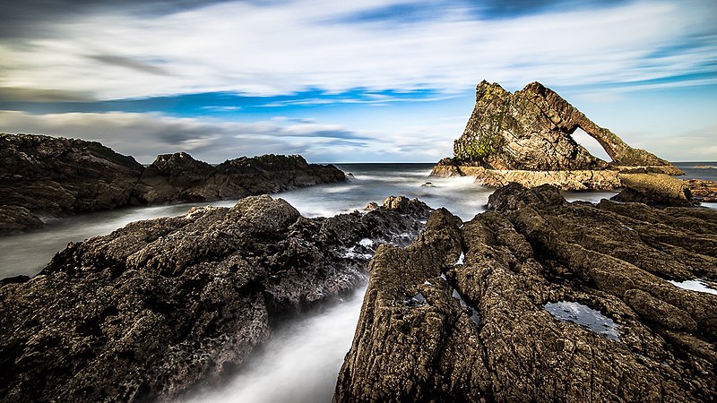
Portknockie, a fishing village in Moray just inside the border with Aberdeenshire, was founded in 1677 and during the 19th century became important for herring fishing. The harbour is overlooked by Green Castle, which was once a Pictish stronghold. The stretch of coast around Portknockie is known for its striking coastal scenery, which includes wierd and wonderful shapes and arches, the best known of which is the Bow and Fiddle which emerges from the sea just offshore. There are also a number of caves, one of which, the Preacher's Cave, was used as a church in the early 19th century. A walk along the cliff top towards Findochty provides wonderful views across the Moray Firth to the Black Isle.

Map of the area.

Bow Fiddle, Portknockie Scotland United Kingdom (103630775). Photo by Giuseppe Milo, via Wikimedia Commons.