Labels

Aberdeenshire (21) Angus (4) antiquities (87) Argyll and Bute (35) Arran (7) art (37) birds (231) bridge (9) Caithness (12) Carmarthenshire (5) castle (164) Ceredigion (9) Channel Islands (13) Cheshire West and Cheshire (1) City and County of Swansea (1) City of Bristol (2) City of Edinburgh (4) Conwy (8) Cornwall (74) County Antrim (19) County Down (23) County Durham (3) County Londonderry (4) Cumbria (19) Denbighshire (2) Devon (48) diving (9) Dorset (18) Dumfries and Galloway (22) Dundee City (1) East Lothian (6) East Sussex (16) East Yorkshire (6) English Riviera (3) Essex (17) Fife (19) Flintshire (1) food (12) fossils (14) gardens (28) Ghosts (35) Glamorgan (1) Gower (7) Guernsey (4) Gwent (1) Gwynedd (19) Hampshire (13) Highland (72) Inner Hebrides (42) Inverclyde (5) Islay (8) Isle of Anglesey (14) Isle Of Man (7) Isle Of Wight (10) Isles of Scilly (3) Jersey (7) Kent (22) Lancashire (8) Lewis and Harris (7) lighthouse (62) Lincolnshire (8) Merseyside (8) Mid Glamorgan (1) mining (23) Moray (10) Mull (8) Norfolk (21) North Ayrshire (13) North Yorkshire (12) Northern Ireland (45) Northumberland (17) Orkney (10) Outer Hebrides (14) Pembrokeshire (27) pubs (48) Ross and Cromarty (20) Scotland (299) Scottish Borders (3) Shetland (14) shipwrecks (42) Skye (12) smuggling (48) Somerset (9) South Ayrshire (6) South Glamorgan (5) South Gloucestershire (2) Suffolk (18) surfing (90) Sutherland (16) Tyne and Wear (8) Wales (93) wartime (75) webcams (232) West Dunbartonshire (3) West Glamorgan (9) West Sussex (9)
Showing posts with label West Sussex. Show all posts

Tuesday, 31 May 2011

WORTHING

The stretch of coast heading east from Littlehampton is characterised by an almost unbroken string of coastal development. There are a series of small communities along the coast towards Worthing – Rustington with its flint cottages, Angmering-On-Sea with a 12th-century church, Ferring with a Norman church and Goring-by-Sea, a residential suburb of Worthing. Worthing is another of those fully-fledged traditional resorts which pepper the Sussex coast. Worthing made the transition from fishing hamlet to fashionable resort after a visit in 1798 by Princess Amelia, the sickly younger sister of the Prince Regent, who came to the town for health reasons. The local museum has a collection of costumes from 1700 to the present day as well as other events and exhibitions. A restored windmill, High Salvington Windmill, stands on the northern edge of the town.

There is an ancient oak tree standing on a triangle of land at a road intersection which used to be at the end of Broadwater Green.  According to legend, skeletons used to rise on Midsummer Eve and dance around the trunk until the first cock crowed.

Other attractions in the town include the Connaught Theatre and The Forge gallery.

For a list of events in Worthing follow this link.

Map of the area.


File:Boat on Worthing Beach, West Sussex - geograph.org.uk - 1113243.jpg
Boat on Worthing Beach, West Sussex - geograph.org.uk - 1113243. Photo by Roger Kidd, via Wikimedia Commons.

Monday, 30 May 2011

LITTLEHAMPTON

Heading east from Middleton-On-Sea, we come to Climping Sands, and it is possible to walk from here to the mouth of the River Arun, from where there are good views of the castle at Arundel, just inland and a bit further upstream. Littlehampton lies on the east bank of the river. There is a ferry which links the boatyards and marinas of the west bank with the main part of town on the east bank, which is lined by a colourful array of harbourside buildings. Littlehampton is home to a highly acclaimed and architecturally unique cafe called East Beach Cafe. Some might regard it as an eyesore, but it certainly grabs the attention. It is brown in colour, and is meant to resemble a piece of driftwood, though to my mind it calls to mind a kind of layered cliff-face.

The writer John Galsworthy, best known for The Forsyte Saga used to stay at the Beach Hotel, and it was here that he wrote Saint’s Progress, completed in 1919. Not long after that, the town began to be known as the “Children’s Paradise” due to the safe bathing and general child-friendly ambience of the town. At one time there was a cross-channel ferry from here to Honfleur in France, but sadly this has now gone.

For events in the area follow this link.

Map of the area.

File:The East Beach Cafe, Littlehampton - geograph.org.uk - 1407279.jpg
The East Beach Café, Littlehampton - geograph.org.uk - 1407279. Photo by Kevin Gordon, via Wikimedia Commons.


Sunday, 29 May 2011

MIDDLETON-ON-SEA

There are many places on the British coast, particularly in the south and east, which have fallen prey to coastal erosion over the years. In Middleton-On-Sea the erosion was so bad in the 1700s that the medieval church was looking at an uncertain future, and in spite of the best efforts of the rector to put defences in place, the erosion got worse, to the point where human remains from the graveyard started appearing along the shore. The church finally succumbed to the encroaching sea in the 1800s. The battle to defend the locality from the sea continued as the town developed into the 1900s, until finally in the 1990s the local council built eight rock islands offshore to lessen the force of the sea.

One feature of the British seaside which still persists in one form or another today, but which had its heyday in the 1950s and 1960s is the “holiday camp” of which Butlins and Pontins are probably the most famous names, and which was parodied in the popular British comedy series Hi-Di-Hi. One of the earliest examples of these was in Middleton-On-Sea where a seaplane factory which closed after the First World War was turned into a holiday camp by Sir Walter Blount in 1922, and was named the “New City”. The hangars of the former seaplane factory were put to good use, one being turned into a dance floor and another into indoor tennis courts. There were also countless outdoor activities laid on, with the aim of providing a self-contained seaside holiday base. By 1934, the New City had become a hotel and sports club.

Map of the area.
Empty seats at Middleton-on-Sea - geograph.org.uk - 849869. Photo by Basher Eyre, via Wikimedia Commons.


BOGNOR REGIS

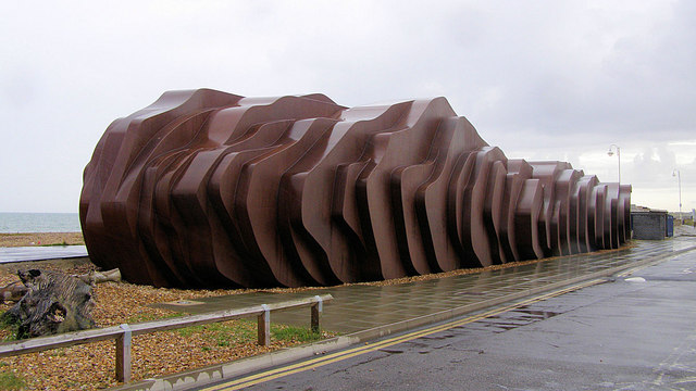
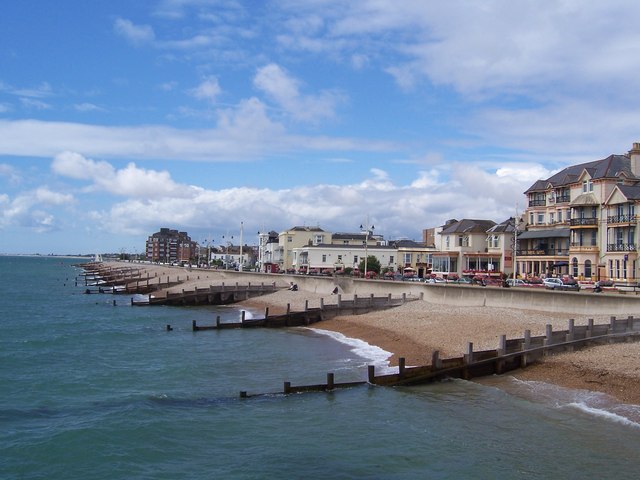
Bognor Regis is one of those “traditional English seaside resorts” with an image problem. People will say things like “Money’s a bit tight, this year’s holiday will have to be a week in Bognor”. As early as the reign of King George V, the monarch was alleged to have uttered the words “Bugger Bognor” when it was suggested that he might convalesce in the town and that he might like to approve the Regis suffix in recognition of this fact (the suffix was granted anyway). There are claims doing the rounds that the words "Bugger Bognor" were the King's last, but this has been proven to be incorrect.  More recently, in 2008, the then Mayor of London, Boris Johnson, writing in the Telegraph, reiterated this expletive when announcing that he would not be holidaying in towns such as Bognor that year, prompting the head of Arun Council, which encompasses Bognor Regis, to challenge him to visit the town to see what a wonderful place it is, and to issue a grovelling apology. At least Bognor was not singled out: Boris managed to insult Eastbourne and Skegness in the same article.

I have only visited the town once, as a child holidaying nearby with my parents, and there was enough to satisfy my simple childlike needs: pier, ice cream, amusements etc. A quick search for 'Bognor Regis' in Google Books unearthed a book from 2008 called “Where To Retire In Britain”, which probably says a lot about the town. It is the sort of sedate seaside retreat favoured by the older generation, while still providing plenty of amusement for families. As well as the pier, fairground rides and so on there is Hotham Park with its Miniature Railway. The town’s tourist website claims that it is the sunshine capital of the country, having the greatest number of hours of sunshine per year. Added to which there are a host of events, including the International Bognor Birdman, in which the competitors, many of them in comedy costumes, fling themselves off the end of the pier to see who can remain airborne for the longest.  Other events include the annual Folk Festival.  So I say “Bugger Boris”, and let’s hear it for Bognor!

For events in Bognor see here.

Live streaming webcam view of the beach.

Map of the area.

File:Bognor Regis - geograph.org.uk - 537839.jpg
Bognor Regis - geograph.org.uk - 537839. Photo by Pam Goodey, via Wikimedia Commons.


Saturday, 28 May 2011

PAGHAM HARBOUR

Pagham Harbour RSPB reserve is almost 150 acres in size and is home to plant and animal habitats of global rarity, for example its flora include Yellow Horned Poppy and Vipers Bugloss which form a backdrop to the seafront. In 1863 the harbour was described by “The Channel Pilot” as “so completely choked up by ever shifting banks that as a harbour it is utterly useless”. This rather dismissive description has been somewhat vindicated in more recent times by the fact that the Harbour now enjoys the status of a Site of Special Scientific Interest. Rare birds to be found here include the Little Tern, Ruff and Pintail.

There is a church beside Pagham Harbour called St Wilfrids which actually includes the chancel of the original Norman building, the remainder having been moved to Selsey. The font is Victorian, and thought to have come from the demolished church of St Martin in Chichester, while earthworks outside the church are all that remain of what is thought to have been an 11th century castle.

Map of the area.

File:Ferry Pool, Pagham Harbour - geograph.org.uk - 765577.jpg
Ferry Pool, Pagham Harbour - geograph.org.uk - 765577. Photo by Simon Carey, via Wikimedia Commons.


Wednesday, 25 May 2011

SELSEY

The gentle headland sticking out to the east of East Wittering is Selsey Bill. Looking back over the news archives for this headland, the overriding theme seems to be frightful storms, whether it’s “heavy storms” (1908), “lashing winds” (1929), or “The Night The Selsey Twister wrecked a town” (1998). In fact, the 1998 tornado was not the first one experienced by Selsey: there was a less serious one in 1986. I still remember the news footage of the aftermath of the 1998 tornado, which included shots of the distinguished astronomer Patrick Moore’s garden; he has a house in the town, perhaps because Selsey allegedly has a particularly high incidence of clear night skies, something which is a rare commodity in Britain, and the tornado partially destroyed his observatory.

On its calmer days Selsey Bill offers great views of the Isle of Wight and eastwards along the coast. There are sandy beaches either side of the Bill, although bathing can be hazardous. At East Beach, visitors can buy locally caught fish and shellfish.

Map of the area.

Selsey - geograph.org.uk - 5078. Photo by Brendan and Ruth McCartney, via Wikimedia Commons.


Sunday, 22 May 2011

THE WITTERINGS

Continuing further out to the mouth of Chichester Harbour and beyond round the coast, we come to the village of West Wittering and its neighbour, the larger East Wittering. Rock legend Keith Richards has a house in West Wittering, and in 2007, in an admirable display of solidarity with the local residents, he joined a protest march in Chichester against cuts at the local hospital. A more ignominious event involving the star took place back in 1967, when police raided a party held at the house whose guests included George Harrison and his then wife Patty Boyd, along with a female reportedly wearing nothing but a fur coat believed to have been Marianne Faithfull. The police search of the premises resulted in the arrest of Richards and Mick Jagger for possession of drugs.

East Wittering has a history stretching back to the Norman Conquest and beyond, and has a partly Norman church. In 1861, Black’s Guide to the South-Eastern Counties of England described the bay here as having “excellent sands, affording at low water a capital promenade”. Nowadays the bay is a magnet for surfers, enough to prompt a comment on the Beach Wizard website from a local resident: “East Wittering is the absolute mutts nuts for surfing”. 

Live streaming webcam of the surf at East Wittering.  

Map of the area.

File:Sunset at West Wittering - panoramio (5).jpg
Sunset at West Wittering - panoramio(5). Photo by ogwen, via Wikimedia Commons.


Thursday, 19 May 2011

CHICHESTER

The pleasant, historic cathedral city of Chichester is not actually by the sea as such, but it is very near, and has a couple of waterside spots nearby worthy of mention. The wharf at Dell Quay was built in the 16th century, and was once the seventh most important port in England. It is still visited by a multitude of vessels, and there are harbourside footpaths to walk along. The Quay is part of Chichester Harbour, an AONB, or Area of Outstanding Natural Beauty, run by Chichester Harbour Conservancy, based in the village of West Itchenor. There is a Harbour Education Centre which runs marine field trips as well as art and photography courses.  From the Canal Basin in the city itself, it is possible to take a pleasant canal boat trip.  The cathedral with its imposing spire can be seen rising up majestically from the flat terrain around the city.  Other attractions in the city include the Pallant House Gallery, with a permanent Modern British collection plus temporary exhibitions.

Going back even further in time, the Romans used the harbour, which was navigable all the way to Fishbourne, the site of a Roman palace which was excavated during the 1960s. The palace was built in the 1st century and there are differing theories about who owned it, one being that the early phase of the palace belonged to King Cogidubnus, who although a British king, actually supported the Roman invasion, in return for which he was able to rule on their behalf. Another theory is that it was built for Sallustius Lucullus, a Roman Governor of Britain. There is a modern building which has been built to protect the precious mosaics and other remaining features of the interior, but visitors can handle Roman artefacts at the Collections Discovery Centre.

For events in Chichester follow this link.

Live streaming webcam from Itchenor Sailing Club near Chichester.

Map of the area.

File:Chichester Cathedral - geograph.org.uk - 1287890.jpg
Chichester Cathedral - geograph.org.uk - 1287890. Photo by Chris Gunns, via Wikimedia Commons.

Monday, 16 May 2011

BOSHAM

Bosham is a picturesque village surrounded by creeks with a marina and sailing club. There is plenty of interest here for lovers of waterborne pursuits and wildlife, but the village’s most notable feature is its Saxon Holy Trinity Church. King Harold, England’s last Saxon King, who is thought to hail from Bosham, set out from the village in 1064 on his way to Normandy, a trip which proved to be the prelude to the Norman conquest of England two years later. Before leaving the village, he stopped at the church to pray, and as if to serve as a reminder of this, the church now contains a copy of a panel of the famous Bayeux Tapestry which depicts a feast in the local manor house attended by Harold, followed by a blessing service in the church, following which he set off in his boat for Normandy. It was in Bosham that Harold kept his fleet, and the vessels were probably also built there. Another regal character associated with Bosham is King Canute; it was allegedly here that he commanded the waves to go back.

Map of the area.

File:Bosham Harbour.JPG
Bosham Harbour. Photo by Charlesdrakew, via Wikimedia Commons.