Labels

Aberdeenshire (21) Angus (4) antiquities (87) Argyll and Bute (35) Arran (7) art (37) birds (231) bridge (9) Caithness (12) Carmarthenshire (5) castle (164) Ceredigion (9) Channel Islands (13) Cheshire West and Cheshire (1) City and County of Swansea (1) City of Bristol (2) City of Edinburgh (4) Conwy (8) Cornwall (74) County Antrim (19) County Down (23) County Durham (3) County Londonderry (4) Cumbria (19) Denbighshire (2) Devon (48) diving (9) Dorset (18) Dumfries and Galloway (22) Dundee City (1) East Lothian (6) East Sussex (16) East Yorkshire (6) English Riviera (3) Essex (17) Fife (19) Flintshire (1) food (12) fossils (14) gardens (28) Ghosts (36) Glamorgan (1) Gower (7) Guernsey (4) Gwent (1) Gwynedd (19) Hampshire (13) Highland (72) Inner Hebrides (42) Inverclyde (5) Islay (8) Isle of Anglesey (14) Isle Of Man (7) Isle Of Wight (10) Isles of Scilly (3) Jersey (7) Kent (22) Lancashire (8) Lewis and Harris (7) lighthouse (62) Lincolnshire (8) Merseyside (8) Mid Glamorgan (1) mining (23) Moray (10) Mull (8) Norfolk (21) North Ayrshire (13) North Yorkshire (12) Northern Ireland (45) Northumberland (17) Orkney (10) Outer Hebrides (14) Pembrokeshire (27) pubs (50) Ross and Cromarty (20) Scotland (299) Scottish Borders (3) Shetland (14) shipwrecks (42) Skye (12) smuggling (48) Somerset (9) South Ayrshire (6) South Glamorgan (5) South Gloucestershire (2) Suffolk (18) surfing (92) Sutherland (16) Tyne and Wear (8) Wales (93) wartime (75) webcams (232) West Dunbartonshire (3) West Glamorgan (9) West Sussex (9)
Showing posts with label pubs. Show all posts

Friday, 20 October 2017

MILLISLE AND DONAGHADEE


Millisle makes a good spot for a nice safe swim for families, with the beach forming a natural lagoon and a large open-air pool alongside.  There are also rockpools to explore and a picnic area and playground at the back of the beach.  Just inland is the Ballycopeland Windmill, built around the late 18th/early 19th century and restored to full working order after a period of disuse.  There is a small visitor centre at the windmill.

Donaghadee is a harbour town with a long history and seafaring tradition.  The Normans left their mark in the form of a motte which is a main feature of the townscape, now topped by a 19th century building formerly used to store explosives.  In 1662 a sea crossing from Donaghadee to Portpatrick in Scotland was established, a distance of just 22 miles, making it the shortest distance between Ireland and Scotland.  The town’s port was the most important in Northern Ireland before being overtaken by Belfast. The harbour, which was started in at least the 17th century, was enhanced by the addition of a lighthouse.  Construction of the lighthouse with its limestone tower was started in 1836 and it was the first lighthouse in Ireland to be lit by electricity.  Though the sea crossing is no longer used, the town is a popular destination for visitors who want to enjoy the leisure facilities such as angling or walking along the shore enjoying the views across to Scotland.  Donaghadee boasts a pub, Grace Neill’s, which is reputedly the oldest in Ireland.    

In January 1953 the brave lifeboat men of Donaghadee were called out to the aid of a ferry called MV Princess Victoria which had left Stranraer, emerging from the relative safety of Loch Ryan to find itself confronted with severe gales.  This awful weather was part of the same disastrous weather system which was responsible for the flooding and loss of life in other parts of the UK, notably the east coast.  Initially the captain was going to return the vessel to Stranraer, but after being hit by a large wave he changed his mind and headed for Northern Ireland.  The subsequent nightmare journey culminated in the Princess Victoria going under just five miles from the County Down coast.  The crew of the Sir Samuel Kelly from Donaghadee were able to save the lives of 34 of the passengers.  The 135 people who lost their lives included Maynard Sinclair, the deputy prime minister of Northern Ireland.
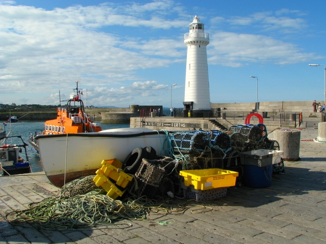

File:Boat and tackle, Donaghadee - geograph.org.uk - 935175.jpg
Boat and tackle, Donaghadee - geograph.org.uk - 935175. Photo by Ross, via Wikimedia Commons.

Saturday, 17 December 2016

SENNEN


When I was growing up in Cornwall Sennen was one of my favourite places to go to the beach, with the long sweeping sands of Whitesands Beach backed by sheltered dunes.  Sennen is one of Cornwall’s most popular surfing spots, and not wanting to miss out on the action, I acquired a polystyrene child’s surfboard which was meant to be used lying down.  However one day, in a fit of surfing dude envy, I decided I was going to stand on it and it promptly broke, and that, sadly, was the end of my surfing ambitions.

The village itself is small, with a pub and a small collection of cafes and shops, and a gallery which occupies a building known as the Roundhouse, a distinctive round building which was erected in 1876 to house a large capstan wheel which was previously open to the elements.  And the elements here can be dramatic, given Sennen’s exposed location at the end of the country.  In February 2014 the village was battered by a monster storm during which massive waves up to 200 feet crashed over the shore.  Follow this link for footage of the action.  Up the hill from the village is another pub called the First And Last Inn which is famous for being haunted by a landlady from the 1800s called Annie George.  She was left to drown on the beach after giving evidence of the actions of a notorious local smuggler.  She has been seen roaming the corridors and in her old bedroom, and other manifestations include glasses moving of their own accord.  Sennen was a hive of smuggling activity at that time, when ‘wreckers’ would lure ships to the rocks, kill the crew and loot the cargo.  Tunnels at the pub were used to conceal the contraband.

From Sennen, the South West Coast Path heads past the Mayon Old Coastguard Lookout, and barely a mile further on we come to Land’s End, which is where I started this blog in January 2011!  But don’t go away, because there’s still the Scillies and the coast of Northern Ireland to come.

Map of the area.

Live streaming webcam of the beach.


Friday, 11 November 2016

GURNARD'S HEAD


This prominent headland on the stretch of coast between St Ives and Lands End got its name from the fact that its shape is reminiscent of the gurnard fish.  There has always been a lone pub on the headland as long as I can remember.  Back in the day it was a normal, unassuming St Austell Ales inn, but now, as a sign of the times, it has been turned into a smart hotel and gastropub, no doubt a welcome stop along this wild coast for those walking the South West Coast Path. 

There is an iron age hill fort called Trereen Dinas (‘fort at the farm on the point’) on the headland, the remnants of which can still just about be made out in the form of a ditch and a bank with some drystone walling.  In the early 1800s there was a copper mine named Wheal Treen in operation on Gurnard’s Head, but it fell into disuse in 1877.  Now there is just the hotel and the nearby village of Treen.  The nearest beach to the headland is Treen Cove, a short distance to the east of the headland.  Probably not one for families, as there are no facilities and no lifeguard cover, just the wild beauty of the Atlantic breakers crashing on to the shore.

Map of the area. 

Gurnard's Head, by Barbara Ashley

Monday, 29 August 2016

PERRANPORTH


The ‘Perran’ part of Perranporth derives from St Piran, the Patron Saint of Cornwall.  Legend has it that he was washed up on Perranporth beach, having been unceremoniously ejected from Ireland by an Irish King suspicious of his powers.  On his arrival he decided to set up an oratory where, the story goes, he found himself preaching Christianity to a congregation consisting of a badger, a fox and a bear.  The oratory was swallowed up by the sand from the surrounding dunes, but it was later excavated, then in 1981 it was buried again to preserve the structure.  The site is now marked by a memorial stone.  Another religious building to succumb to the dunes was the parish church dating from around 1150 and abandoned in 1804.  Only the ruined walls remain plus an ancient cross from the 10th century or earlier.  St Piran also lends his name to Piran Round, an Iron Age hill camp to the north-east of the village.  

Several centuries after St Piran’s arrival, tin and copper mining became the main activity in and around the village.  Perhaps this provided inspiration for Winston Graham, the author of the Poldark novels, who wrote the first one while living there.  Of course, the mining activity has ceased, but there are still reminders in the form of the remains of engine houses dotted around the landscape.  The Perranzabuloe Folk Museum tells the story of the mining industry as well as other aspects of local life (Perranzabuloe means ‘Perran in the sands’).  During the Second World War, there was a Spitfire Station at Perranporth Airfield.  The control tower has a memorial to the pilots who flew from here, who came from many different countries.  Today the airfield has been given over to more leisurely pursuits such as gliding.

Nowadays, Perranporth is a popular small resort where, as well as the sandy beach with caves and interesting rock formations, there is a golf course and a boating lake.  The big event of the year here is the Tunes In The Dunes festival, which takes place around late June/early July.  Penwartha Coombe is a tranquil oasis just outside the village, with a stream running through it.  A walk along the South West Coast Path heading west from Perranporth takes you past Droskyn Point, home to the Perranzabuloe Millennium Sundial.  The sundial tells Cornish time, which is 20 minutes ahead of GMT, so best not to set your watch by it.


File:Millennium sundial above Perranporth beach - geograph.org.uk - 1261455.jpg
Millennium sundial above Perranporth beach - geograph.org.uk - 1261455. Photo by Rod Allday, via Wikimedia Commons.

Saturday, 21 May 2016

TREBARWITH STRAND


Trebarwith Strand was a favourite landing place for smugglers bound for Jamaica Inn, bringing brandy and other contraband.  They may have made use of the caves backing the long stretch of white sand which makes this spot so popular with present-day visitors.  The beach is backed by cliffs, from where slate was once quarried, and there are waterfalls tumbling down towards the sea.  On the horizon is a large lump of rock known as Gull Rock.  The beach is popular with bodyboarders and surfers, and there is gear available to hire as well as a surf school.  Anyone entering the water here should heed the signs warning of potential danger, including the danger of being swept off the rocks by the powerful waves prevalent on this stretch of coast.  There is car parking and a pub with accommodation for anyone wanting to stay overnight, with the chance to experience the wonderful sunset.  Up above the beach is the Trebarwith Valley, an Area of Outstanding Natural Beauty with bluebell woods and a nature trail.  It made the news in 2014 with reports that Prince Charles was selling the valley, complete with an engine house and a waterfall, for £40,000.


File:The Beach at Trebarwith Strand - geograph.org.uk - 487105.jpg
The Beach at Trebarwith Strand - geograph.org.uk - 487105. Photo by John Lucas, via Wikimedia Commons.