Labels

Aberdeenshire (21) Angus (4) antiquities (87) Argyll and Bute (35) Arran (7) art (37) birds (231) bridge (9) Caithness (12) Carmarthenshire (5) castle (164) Ceredigion (9) Channel Islands (13) Cheshire West and Cheshire (1) City and County of Swansea (1) City of Bristol (2) City of Edinburgh (4) Conwy (8) Cornwall (74) County Antrim (19) County Down (23) County Durham (3) County Londonderry (4) Cumbria (19) Denbighshire (2) Devon (48) diving (9) Dorset (18) Dumfries and Galloway (22) Dundee City (1) East Lothian (6) East Sussex (16) East Yorkshire (6) English Riviera (3) Essex (17) Fife (19) Flintshire (1) food (12) fossils (14) gardens (28) Ghosts (36) Glamorgan (1) Gower (7) Guernsey (4) Gwent (1) Gwynedd (19) Hampshire (13) Highland (72) Inner Hebrides (42) Inverclyde (5) Islay (8) Isle of Anglesey (14) Isle Of Man (7) Isle Of Wight (10) Isles of Scilly (3) Jersey (7) Kent (22) Lancashire (8) Lewis and Harris (7) lighthouse (62) Lincolnshire (8) Merseyside (8) Mid Glamorgan (1) mining (23) Moray (10) Mull (8) Norfolk (21) North Ayrshire (13) North Yorkshire (12) Northern Ireland (45) Northumberland (17) Orkney (10) Outer Hebrides (14) Pembrokeshire (27) pubs (50) Ross and Cromarty (20) Scotland (299) Scottish Borders (3) Shetland (14) shipwrecks (42) Skye (12) smuggling (48) Somerset (9) South Ayrshire (6) South Glamorgan (5) South Gloucestershire (2) Suffolk (18) surfing (92) Sutherland (16) Tyne and Wear (8) Wales (93) wartime (75) webcams (232) West Dunbartonshire (3) West Glamorgan (9) West Sussex (9)
Showing posts with label castle. Show all posts

Thursday, 19 April 2018

DUNLUCE CASTLE


Such is the appeal of the now-ruined Dunluce Castle that it, and its magnificent surroundings, have been the inspiration for both poetry and music.  The 4-part poem published in 1814 by Edward Quillinan sets the scene at length, describing the castle itself, the roar of the Atlantic “in wildest fury frantic” and the dramatic coastline around it.  A tone poem called Dunluce was written in 1921 by Irish composer Norman Hay, while a more recent musical work called Dunluce Castle was performed by the Irish Rovers in the 1990s.  The castle made an appearance on the sleeves of two albums: Led Zeppelin’s Houses of the Holy in 1973 and American musician Jandek’s Glasgow Friday in 2008.  The castle is believed to have been the inspiration for Cair Paravel in Chronicles of Narnia by C. S. Lewis.  Finally, not surprisingly, the castle was one of the many Northern Irish locations used in Game of Thrones as the castle of Pyke, seat of House Greyjoy.


Dunluce Castle was the first stop on our wonderful drive along the Causeway Coast a few years ago, and it set the scene magnificently for the rest of it.  The castle was built by the MacQuillan family around the year 1500, but 50 years later it was seized by the MacDonnell clan.  There was once a small town called Dunluce, founded by the Earls of Antrim in the 17th century.  The town was abandoned long ago, but visitors can view the remains uncovered by an archaeological dig.  The castle’s precarious position perched over the foaming sea was allegedly the cause of a catastrophe in 1639, when the castle’s kitchen fell into the sea along with the unfortunate kitchen staff while the 2nd Earl of Antrim and his wife were waiting for their dinner.  However, the veracity of this story is in some doubt, since the kitchen is still in situ among the present-day ruins.  What is for sure is that in the 18th century the north wall of the residence building did fall into the sea.  The remaining walls are still standing. 


File:Awesome Dunluce Castle.jpg
Awesome Dunluce Castle. Photo by Osioni, via Wikimedia Commons.


Thursday, 8 March 2018

DUNSEVERICK


The hamlet of Dunseverick, on the way from the Carrick-A-Rede Rope Bridge to the Giant’s Causeway, is tiny but with several points of interest.  Dunseverick Castle and earthworks, on a peninsula managed by the National Trust, date from at least the 5th Century AD when St Patrick visited and baptized Olcán, a local man who later became Bishop of Ireland.  The Gate Lodge of the castle can still be seen standing proud, although ruined, on the grassy clifftop.  There is a well on the headland named after St Patrick.  Walkers can take the North Antrim Cliff Path from the castle to the Giant’s Causeway, a distance of 5 miles. 

The harbour, sheltered by basalt islets, was where many local people emigrated from during the19th century.  They were rowed out from here to schooners headed for Glasgow or Londonderry before continuing with their onward journeys.  Between the harbour and the castle, Dunseverick Falls, although not the most dramatic of waterfalls, make a picturesque sight as they tumble down to the sea.

Map of the area.


File:Dunseverick Castle - geograph.org.uk - 475761.jpg
Dunseverick Castle - geograph.org.uk - 475761. Photo by Anne Burgess, via Wikimedia Commons.


Wednesday, 28 February 2018

KINBANE CASTLE AND THE CARRICK-A-REDE ROPE BRIDGE


Heading north from Ballycastle on the way to Ballintoy we come to Kinbane Castle, reachable by a minor road off the Whitepark Road.  The castle is in ruins and there are many steps leading down to the main castle area, but those fit enough to tackle the approach will be rewarded with some of the best views on the Antrim coast.  The castle was built in 1547 by Colla MacDonnell, brother of Sorley Boy MacDonnell, and was laid siege to more than once by English forces.


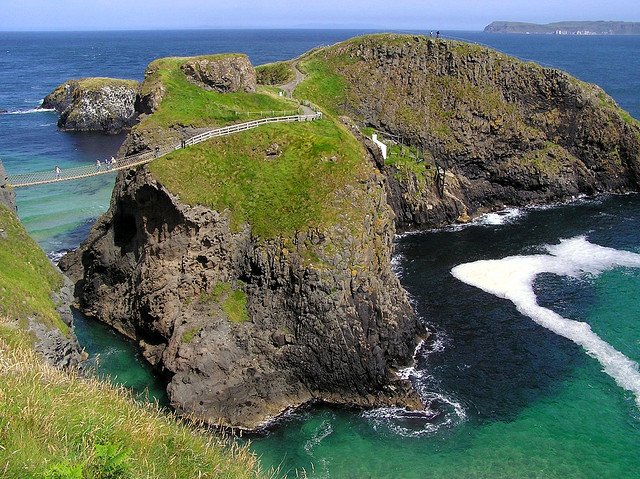
As a member of the National Trust, I have visited many of their properties over the years, but possibly the most unusual site I have been to is the Carrick-a-Rede Rope Bridge.  The bridge was originally built in 1755 by fishermen to provide access to the small offshore island called Carrick, from where they were able to fish for salmon.  Now, under the auspices of the Trust the bridge is solely a novel tourist attraction, providing a frisson for visitors as they wobble their way across while daring themselves to look down at the foaming sea below.  The bridge is a popular attraction, so be prepared to wait to make the crossing, which is only 20 metres.  The island itself is very small, but offers wonderful coastal views and birdlife.  Back at the entrance to the site there is a cafe for visitors to warm up in.  The nearby village of Ballintoy has a number of facilities for visitors in the area, and the harbour is worth a visit for Game of Thrones fans, as it was used for the Iron Islands scenes.


File:Carrick a Rede.jpg
Carrick a Rede. Photo by Qole Pejorian, via Wikimedia Commons.


Friday, 9 February 2018

CUSHENDUN


Like Cushendall, Cushendun, at the foot of Glendun, one of the nine Glens of Antrim, is classed as a “conservation village”, and as such is protected by the National Trust.  The name comes from the Irish Cois Abhann Duinne, which means “beside the River Dun”, the river that tumbles down from the valley of Glendun.  The village was planned in 1912 by Clough Williams-Ellis at the request of Baron Cushendun, and the Cornish appearance of the village is no accident, as Williams-Ellis designed it in this way to please the Baron’s wife Maud, who was from my home town of Penzance.  There is even a row of whitewashed cottages named after her. The village passed to the care of the National Trust in 1954.


Just to the north of the village is Castle Carra, thought to have been built in the 14th century and now a ruin.  The castle was the scene of a series of shenanigans involving Shane O’Neill and the McDonnells, culminating in O’Neill being stabbed to death as revenge for his earlier defeat of the McDonnells.  Not content with this act of violence, they cut his head off and sent it to representatives of Queen Elizabeth in Dublin. 


Last, and by no means least, fans of the hit series Game of Thrones will want to include a visit to Cushendun Caves on a visit to the village.  The caves, formed from over 400 million years of weathering, appeared in the series as the background for the Stormlands, one of the nine constituent regions of the Seven Kingdoms.  They can be reached by following the walk suggested via this link.  


File:Cushendun Caves - geograph.org.uk - 467791.jpg
Cushendun Caves - geograph.org.uk - 467791. Photo by Anne Burgess, via Wikimedia Commons.

Wednesday, 24 January 2018

RED BAY


To the north of Carnlough the shore-hugging Causeway Coastal Route veers to the west, where it reaches Red Bay.  Glenariff, one of the nine “Glens of Antrim” and known as the “Queen of the Glens”, drops down to the sea here, and there is a small village by the same name.  Glenariff Forest Park speads over 1,000 acres, with woodlands, lakes, waterfalls and recreational areas.  Just beyond the neighbouring village of Waterfoot lie the ruins of Red Bay Castle, built in the 13th century by the Bissett family, self-styled Lords of the Glens of Antrim.  The family’s descendents, the MacDonells of Antrim, rebuilt the castle in the 16th century, only for it to be burned to the ground in 1565 by Shane O’Neill of Tyrone.  The MacDonnells rebuilt it again, but it fell into disrepair and after a further restoration was subsequently destroyed by Oliver Cromwell during his conquest of Ireland, hence the scant ruins on view today.  So not much to see here now, but worth swinging by anyway for the wonderful views across to the Mull of Kintyre.


File:Waterfoot, Co. Antrim, 1990 (6981329372).jpg
Waterfoot, Co. Antrim, 1990 (6981329372). Via Wikimedia Commons.


Thursday, 11 January 2018

GLENARM

Glenarm and its surroundings constitute one of the nine “Antrim Glens”, or valleys which are among the attractions of this part of Northern Ireland.  The glen itself, the river, the bay and the village are all called Glenarm, which stands for “Glen of the Army”, a reminder of a bloody past dating back to the Normans.  The harbour at Glenarm has a long history, but has been restored and updated, and nowadays houses a marina used by yachts and pleasure boats.  The village itself, dating from the 17th century, is a Conservation Area. 

Across the river from the village is Glenarm Castle and Walled Garden, home to the Dunluce family.  The castle originates from the 13th century when one John Bisset, expelled from Scotland for murder, arrived in the area and established a castle for the defence of his newly acquired land.  However, it was in 1636 that the present-day version of the castle was built by the Earl of Antrim Sir Randall McDonnell. The Walled Garden dates from the 18th century and is one of Irelands oldest.  There is a tea room which last year had a glowing write-up in the Belfast Telegraph.  The garden is open to visitors from March until September, however the castle itself is only occasionally open to the public, and is available for group visits.  The Glenarm Forest Park used to be part of the demesne of Glenarm Castle but is now open to the public and maintained by Ulster Wildlife Trust.


File:Glenarm Castle.jpg
Glenarm Castle. Photo by Glenarm Castle, via Wikimedia Commons.


Friday, 5 January 2018

LARNE


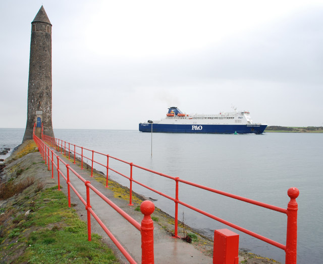
Larne is a major gateway to Northern Ireland courtesy of the ferry link to Cairnryan, 6 miles north of Stranraer in Scotland.  Formerly known as Latharna, from Lathar, son of the pre-Christian King Hugony the Great, one of the earliest records of the area dates from Roman times, when a galley bound for Scotland was blown off course to a place called Portus Saxa, believed to be Larne Lough.  The lough was later named after the Norse King Ulfrich during the time of the Viking raids.  Fast forward to the 18th century, when the quays which had been built in the port were used by people emigrating to America.  It was the coming of the railway which led to Larne being established as the departure point for ferries to Scotland, initially using a paddlesteamer called the Briton, a service which lasted until 1863.  Three years later the harbour was bought by James Chaine, a linen merchant’s son, who updated the port and re-established the link to Scotland.   People arriving at Larne by sea will be reminded of this by the Chaine Memorial Tower which dominates the harbour entrance. 


During the First World War Larne became a naval port, then during the Second World War the port played an important role for the Allied Forces, including as a conduit for troops preparing for the D-Day Landings.  In the post-war period, after various ups and downs with efforts to establish ferry links once more, the Larne-Cairnryan service finally started in 1973.  This outcome, which contributed considerably to the success of the port, was facilitated by one Colonel Frank Bustard, who was made a Freeman of Larne in recognition of his efforts.


If you are visiting Larne with a car or motorbike, the coastal route heading north from the town is highly recommended.  We did this route in the other direction after exploring the Antrim coast, and the journey was a delight due to the way the road hugged the coastline with the attendant views of Scotland.  At one point I nearly caused my husband to crash the car when I spotted a seal poking its head out of the water a short distance offshore. 


Back in town, the Larne Museum and Arts Centre provides a fascinating insight into the history of the town, including a display devoted to a famous warship called the Princess Victoria.  For lovers of the great outdoors, as well as the tower, James Chaine’s memory lives on in the form of Chaine Park, a green space with wonderful views, especially for people who, like me, love watching the comings and goings of shipping and ferries.  Just to the south of the port, the ruins of Olderfleet Castle, dating from at least the 13th century, lie on Curran Point facing the Lough.


For a list of events in Larne, follow this link.


File:The Chaine Memorial, Larne - geograph.org.uk - 620971.jpg
The Chaine Memorial, Larne - geograph.org.uk - 620971. Photo by Albert Bridge, via Wikimedia Commons.


Tuesday, 28 November 2017

CARRICKFERGUS


Many people like to dress up for marathons, as viewers of the annual London marathon will know – everything from a lion suit to a full antique diving suit.  What has this got to do with Carrickfergus I hear you cry?  Well, earlier this month a couple from Carrickfergus who are members of the local running club decided to work a marathon run into their wedding celebrations.  The couple, accompanied by their guests, changed into running gear with a wedding theme and ran a variety of distances so that as many people as possible could take part, right up to the full 26 miles.

Carrickfergus is on the north shore of Belfast Lough, just over the Antrim side of the County Down/County Antrim border which crosses the eastern suburbs of Belfast.  The town takes its name from Fergus the Great, a legendary king of Dál Riata, a kingdom that encompassed parts of Western Scotland as well as northeastern Ireland.  Carrickfergus was a prominent settlement before Belfast, meaning that until the 17th Century the Lough was known as Carrickfergus Bay.  John de Courcy, the Anglo-Norman knight who we have met several times already in this blog, established his headquarters here in the 12th century and built Carrickfergus Castle on "Carraig Fhearghais" (the rock of Fergus) in 1177.  

Carrickfergus has had an eventful history over the centuries, at one point even becoming involved in the American War of Independence.  During the Nine Years War, a struggle against English rule which began at the end of the 16th century, the town was the scene of the Battle of Carrickfergus, which saw the English defeated.  The much wider Seven Years’ War in the mid-18th century brought the forces of William of Orange to the town, where they besieged the castle for several days and William himself arrived on the scene.  In 1777 there was a naval duel off Carrickfergus between the British Royal Navy vessel HMS Drake and the 18-gun sloop Ranger of the Continental Navy, as the US Navy was called during the War of Independence, which the Americans won.  By the time of World War Two relations with the US had improved to the point where the US Rangers used the Sunnylands Camp in Carrickfergus for training before heading to Normandy.  The Andrew Jackson Cottage and US Rangers Centre includes a museum dedicated to the US Rangers.

Carrickfergus Castle is still remarkably well preserved and is open to visitors, with historical displays on view.  The castle occupies a fetching position on the northern shore of Belfast Lough.  Near the castle is the King William III (William of Orange) monument, a statue of the king commemorating his landing in the town.  Further away from the shore, the Carrickfergus Museum, attached to the Civic Centre, has displays dating from the Middle Ages onwards.  For visitors staying in Belfast, the town is easily reached by car or train from the capital.


File:Carrickfergus Castle (2) - geograph.org.uk - 733522.jpg
Carrickfergus Castle (2) - geograph.org.uk - 733522. Photo by Albert Bridge, via Wikimedia Commons.

Friday, 1 September 2017

PORTAFERRY


Portaferry lies at the narrow entrance to Strangford Lough and at the southern end of the Ards Peninsula, and the ‘ferry’ part of the name is appropriate, this being the departure point for ferries to Strangford on the other shore.  The ferry takes cars as well as foot passengers.  Portaferry Castle was built in the 16th century, probably by the Savage family.  Now a ruin, it was built as a square, 3-storey tower house with an L-shaped turret.  Just outside the town is the Portaferry Windmill, dating from the 17th century and built by the Savage family, and one of over 50 windmills which once graced the Ards Peninsula.  Near the castle is the Exploris Aquarium, which includes a seal sanctuary.  The town also has a Sailing Club, which is known for events such as the Galway Hooker Regatta for traditional boats.  


File:Portaferry (01), August 2009.JPG
Portaferry (01), August 2009. Photo by Ardfern, via Wikimedia Commons.

Wednesday, 26 July 2017

KILLYLEAGH


During the 12th century, Killyleagh and the other towns and villages around Strangford Lough were under threat from invasion by the Vikings.  But the area had already been conquered during the same century by Normans, including a Norman knight called John de Courcy, who came to Ireland from Somerset.  While there he built a number of castles with the aim of keeping the Vikings at bay, and one of these was Killyleagh Castle, believed to be the oldest inhabited castle in Ireland.  As well as its current permanent inhabitants the castle offers self-catering accommodation for tourists, and it is also used as a concert venue, with past appearances by Van Morrison among others.

The village lies in a tranquil setting on a small inlet on the western shore of the Lough, the pastel-hued cottages giving the waterfront an attractive appearance.  The town was recently reported as being the last predominantly Protestant settlement in the Strangford constituency, a contrast from the mainly Catholic Downpatrick just down the road.  Apart from a bomb in a Catholic-owned bar in 1975 the village escaped the worst of the Troubles and now has a prosperous air.  The parish church, in a slightly elevated position with views of the Lough, is dedicated to St John the Evangelist and lies on a site previously occupied by an old pre-Reformation church.  On the road into the village from Downpatrick is Delamont Country Park, with a seasonal miniature railway, a large heronry, camping facilities and the Strangford Stone, a modern-day megalith erected in 1999.

For events in the area, including the Killyleagh Summer Festival, see the town's Facebook page. 


File:Killyleagh Harbour - geograph.org.uk - 24113.jpg
Killyleagh Harbour - geograph.org.uk - 24113. Photo by Bob Jones, via Wikimedia Commons.

Thursday, 29 June 2017

STRANGFORD


Driving north from Killard Point along the road known as Shore Road the route more or less hugs the shore of Strangford Lough, offering lovely views of this large body of water.  At the point where Shore Road joins the A2 is Kilclief Castle, a tower-house castle built in the first half of the 15th century by Bishop of Down John Sely.  However, the Bishop’s residency at the castle came to an ignominious end when he was ejected and stripped of his office for living with a married woman.

Strangford village is located at the mouth of the main part of Strangord Lough.  The name derives from the name given to the inlet by the Vikings: “Strang Fjörthr” meaning “Strong Fjord”.  The first notable building you will come across at this end of the village is the romantically named “St Mary Star of the Sea Church”, built on land donated by Lord Henry Fitzgerald.  Sadly, the church was badly damaged by fire in 1930, but it was rebuilt as the Stella Maris Church, although it is still shown on maps with the original name.  From the attractive waterfront in the centre of the village there is access to a car ferry service to Portaferry on the opposite shore of the lough.

Strangford lies on a small peninsula to the east of an 'inlet-within-an-inlet', and on the other side of this inlet are a couple of further places of interest.  Like Kilclief Castle, Audley's Castle is another 15th century tower house named after one of its owners, John Audley.  The castle, along with the adjoining Audley's Field, was used in the filming of Game of Thrones.  A short distance from the shore is the National Trust owned Castle Ward, a somewhat misleading name as it is actually an 18th century mansion.  This was also used in Game of Thrones, in which the historic farmyard featured as Winterfell, the backdrop for the series pilot.


File:Strangford Harbour front - geograph.org.uk - 69647.jpg
Strangford Harbour front - geograph.org.uk - 69647. Photo by Rogere, via Wikimedia Commons.