Labels

Aberdeenshire (21) Angus (4) antiquities (87) Argyll and Bute (35) Arran (7) art (37) birds (231) bridge (9) Caithness (12) Carmarthenshire (5) castle (164) Ceredigion (9) Channel Islands (13) Cheshire West and Cheshire (1) City and County of Swansea (1) City of Bristol (2) City of Edinburgh (4) Conwy (8) Cornwall (74) County Antrim (19) County Down (23) County Durham (3) County Londonderry (4) Cumbria (19) Denbighshire (2) Devon (48) diving (9) Dorset (18) Dumfries and Galloway (22) Dundee City (1) East Lothian (6) East Sussex (16) East Yorkshire (6) English Riviera (3) Essex (17) Fife (19) Flintshire (1) food (12) fossils (14) gardens (28) Ghosts (36) Glamorgan (1) Gower (7) Guernsey (4) Gwent (1) Gwynedd (19) Hampshire (13) Highland (72) Inner Hebrides (42) Inverclyde (5) Islay (8) Isle of Anglesey (14) Isle Of Man (7) Isle Of Wight (10) Isles of Scilly (3) Jersey (7) Kent (22) Lancashire (8) Lewis and Harris (7) lighthouse (62) Lincolnshire (8) Merseyside (8) Mid Glamorgan (1) mining (23) Moray (10) Mull (8) Norfolk (21) North Ayrshire (13) North Yorkshire (12) Northern Ireland (45) Northumberland (17) Orkney (10) Outer Hebrides (14) Pembrokeshire (27) pubs (50) Ross and Cromarty (20) Scotland (299) Scottish Borders (3) Shetland (14) shipwrecks (42) Skye (12) smuggling (48) Somerset (9) South Ayrshire (6) South Glamorgan (5) South Gloucestershire (2) Suffolk (18) surfing (92) Sutherland (16) Tyne and Wear (8) Wales (93) wartime (75) webcams (232) West Dunbartonshire (3) West Glamorgan (9) West Sussex (9)
Showing posts with label shipwrecks. Show all posts

Thursday, 5 April 2018

PORTBALLINTRAE


Looking at Portballintrae on the map, the eye is drawn to a small but perfectly formed horseshoe-shaped bay.  At one end of this is a small harbour, formerly the haunt of the local fishermen, but nowadays used mostly by leisure craft, and at the eastern end is Salmon Rock Beach which, while popular with families, is risky for swimmers.  The Bush River wends its way down to the coast to the northeast of the village, enclosing the Bushfoot Golf Course.  Back in 2007 it was reported that Donald Trump was considering the village as the site of a £1 billion golf complex, but it never came to pass. 


On the outskirts of the village are two strange mounds of earth forming concentric rings.  Known as the Lissanduff Earthworks, it is not clear what their original purpose might have been.  Some archaeologists, however, think they may have been linked to ancient worship rituals.  Fast forwarding to the 16th century, in 1588 a Spanish galleass called the Girona, part of the Spanish Armada, sank off Lacada Point, further back along the coast from Portballintrae.  In the 1960s a treasure trove from the ship was recovered by a team of Belgian divers, and was hauled ashore at Portballintrae.  It was the greatest find ever recovered from a Spanish Armada vessel and the gold jewellery from the hoard is displayed in the Ulster Museum in Belfast.


File:The bay of Port Ballintrae. - geograph.org.uk - 435121.jpg
The bay of Portballintrae. - geograph.org.uk - 435121. Photo by Des Colhoun, via Wikimedia Commons.


Friday, 20 October 2017

MILLISLE AND DONAGHADEE


Millisle makes a good spot for a nice safe swim for families, with the beach forming a natural lagoon and a large open-air pool alongside.  There are also rockpools to explore and a picnic area and playground at the back of the beach.  Just inland is the Ballycopeland Windmill, built around the late 18th/early 19th century and restored to full working order after a period of disuse.  There is a small visitor centre at the windmill.

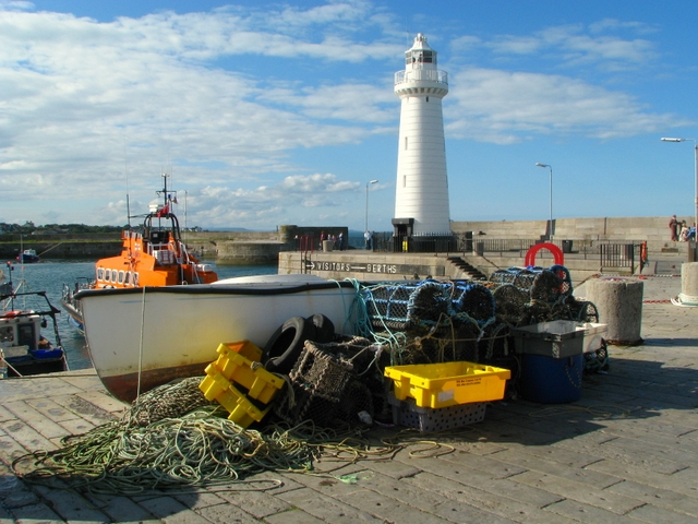
Donaghadee is a harbour town with a long history and seafaring tradition.  The Normans left their mark in the form of a motte which is a main feature of the townscape, now topped by a 19th century building formerly used to store explosives.  In 1662 a sea crossing from Donaghadee to Portpatrick in Scotland was established, a distance of just 22 miles, making it the shortest distance between Ireland and Scotland.  The town’s port was the most important in Northern Ireland before being overtaken by Belfast. The harbour, which was started in at least the 17th century, was enhanced by the addition of a lighthouse.  Construction of the lighthouse with its limestone tower was started in 1836 and it was the first lighthouse in Ireland to be lit by electricity.  Though the sea crossing is no longer used, the town is a popular destination for visitors who want to enjoy the leisure facilities such as angling or walking along the shore enjoying the views across to Scotland.  Donaghadee boasts a pub, Grace Neill’s, which is reputedly the oldest in Ireland.    

In January 1953 the brave lifeboat men of Donaghadee were called out to the aid of a ferry called MV Princess Victoria which had left Stranraer, emerging from the relative safety of Loch Ryan to find itself confronted with severe gales.  This awful weather was part of the same disastrous weather system which was responsible for the flooding and loss of life in other parts of the UK, notably the east coast.  Initially the captain was going to return the vessel to Stranraer, but after being hit by a large wave he changed his mind and headed for Northern Ireland.  The subsequent nightmare journey culminated in the Princess Victoria going under just five miles from the County Down coast.  The crew of the Sir Samuel Kelly from Donaghadee were able to save the lives of 34 of the passengers.  The 135 people who lost their lives included Maynard Sinclair, the deputy prime minister of Northern Ireland.


File:Boat and tackle, Donaghadee - geograph.org.uk - 935175.jpg
Boat and tackle, Donaghadee - geograph.org.uk - 935175. Photo by Ross, via Wikimedia Commons.

Tuesday, 12 September 2017

CLOUGHEY AND KIRKISTOWN CASTLE


The village of Cloughey started out as a row of coastguard cottages at the south end of the beach.  It gained popularity as a holiday destination in the 1920s, helped no doubt by the presence of a golf course and a sandy beach fringing a gently curving bay.  However, not all of this stretch of coast is so benign.  The North and South Rocks in the sea off the village have long been considered one of the major hazards to shipping in the area.  In 1883 a ship called the Wild Deer carrying 300 emigrants heading for New Zealand foundered on the North Rocks in heavy seas.  Happily, the passengers were rescued with the help of the local fishing boats.  No doubt there would have been loss of life were it not for the fact that the passengers were implored to stay below deck, in fact the women were so panicked that the crew locked them in to prevent them from rushing up to the deck.

Kirkistown Castle is about a mile to the north of Cloughey, just outside the golf course bearing the same name.  It is believed to have been built in 1622 by Roland Savage, possibly on the site of an earlier construction.  The castle is typical of the area, with a three-storey tower house.  The tower house was threatened by subsidence, being built in a marshy area, necessitating the later addition of buttresses and iron braces.  There is also a motor racing circuit nearby, which was built on the site of an airfield established during the Second World War for the use of  the American Air Force. 


File:Cloughey Bay - geograph.org.uk - 837592.jpg
Cloughey Bay - geograph.org.uk - 837592. Photo by Albert Bridge, via Wikimedia Commons.

Friday, 23 June 2017

KILLARD POINT


Looking at the map of County Down, the eye is naturally drawn to a large body of water to the south-east of Belfast.  This is Strangford Lough, a large sea loch, and the largest inlet in the British Isles.  At the southern edge of the mouth of the Lough is a peninsula called Killard Point, which includes the Killard National Nature Reserve.  The reserve is reachable from Ballyhornan, a village to the south, via the Lecale Way from which a lane branches off to the right. 

The reserve is rich in both flora, bird life and marine life.  The flora includes wild orchids and an array of other wild flowers, while birdwatchers will see skylarks flitting around in the sky above, and other birds such as terns and sand martins.  The crystal clear waters off the reserve’s sandy bays are home to seals and starfish.  The wild orchids are best seen in June and July.  During World War II RAF Bishops Court was located just outside Ballyhornan, and Killard Point became an outpost of the airfield when radars and height finders were installed there.  Little remains of these facilities today, as the area was returned to a greenfield site. 

About half a kilometre out to sea at Bendberg Bay is Gun’s Island, so named because a French ship called the Amity, which was carrying arms for the 1798 Irish Rebellion, was wrecked just north of the island.  Only one crew member survived.  On the seaward side of Gun’s Island there are colonies of breeding gulls, cormorants, guillemots and kittiwakes.


File:Killard Point - looking down on Benderg Bay - geograph.org.uk - 457888.jpg
Killard Point - looking down on Benderg Bay - geograph.org.uk - 457888. Photo by Michael Diamond, via Wikimedia Commons.

Thursday, 18 May 2017

DUNDRUM


Heading along the coast from Newcastle in a northeasterly direction, we come to a narrow channel leading into Dundrum Bay.  The route takes in Murlough National Nature Reserve owned by the National Trust.  A boarded walkway leads to a wide sandy beach backed by dunes, with sensational views of the Mourne Mountains.  The animal life on the reserve includes rabbits and pigmy shrews, and common and grey seals can sometimes be seen hauling themselves onto the beach. 

The small town of Dundrum lies on the west shore of the bay, which is dominated by the ruined Dundrum Castle.   The castle is believed to have been built in 1177 by the Anglo-Norman knight John de Courcy, just after he invaded Ulster.  A National Trust car park to the north of Dundrum marks the start of the 2.5 Km Dundrum Coastal Path, which follows a disused railway line and forms part of the longer Lecale Way.  The path takes in a variety of habitats supporting birdlife, for example saltmarsh and marshy tall herb stands.  Dundrum Inner Bay is visited by wildfowl and waders in winter, while Green Island in Dundrum Inner Bay attracts oystercatchers, lapwing, redshank and curlew.

The S. S. Great Britain, which we last met in her final resting place in Bristol, ran aground in Dundrum Bay in 1846 during one of her voyages to New York, an accident which caused her engines to be ruined.  She was refloated, but the expense of the operation forced her owners to sell her to Gibbs Bright and Company, who put her to work on the Australian run.


File:Murlough Beach.jpg
Murlough Beach. Photo by Laureljade, via Wikimedia Commons.

Saturday, 23 April 2016

CRACKINGTON HAVEN


The Church of St Gennys provides a clue to the treacherous nature of the water off the coast of the small coastal village of Crackington Haven.  The graveyard includes memorials to seamen who have lost their lives over the years in a series of shipwrecks.  One such was the Swedish brigantine William which lost 7 men in a storm in 1894.  Just six years later a further 7 men were lost when the steamer City of Vienna and the barque Capricornia were lost to storms.  The harbour here used to be used for importing coal and limestone from Wales, and for exporting the slate that was quarried here, but it has reverted to a sleepy cove with a pebble and sand beach, a pub and a bistro.  Pencarrow Point towers over the beach at a height of over 400 feet, and there is spectacular coastal walking to be had over a stretch of coast towards Boscastle given to the National Trust in 1959 by Wing Commander A. G. Parnall to commemorate the airmen who died during the Battle of Britain, including his brother.   Crackington Haven suffered extensive damage from flooding in the great flood of 2004, of which Boscastle was the more famous victim – more about this in the next post.  The area around the village has been designated an Area of Outstanding Natural Beauty as well as a Site of Special Scientific Interest.  The latter is partly due to the geology, with the carboniferous rocks giving rise to the name 'The Crackington Formation'.


File:Coombe Barton Inn at Crackington Haven - geograph.org.uk - 905111.jpg
Coombe Barton Inn at Crackington Haven - geograph.org.uk - 905111. Photo by Rob Wilcox, via Wikimedia Commons.