Labels

Aberdeenshire (21) Angus (4) antiquities (87) Argyll and Bute (35) Arran (7) art (37) birds (231) bridge (9) Caithness (12) Carmarthenshire (5) castle (164) Ceredigion (9) Channel Islands (13) Cheshire West and Cheshire (1) City and County of Swansea (1) City of Bristol (2) City of Edinburgh (4) Conwy (8) Cornwall (74) County Antrim (19) County Down (23) County Durham (3) County Londonderry (4) Cumbria (19) Denbighshire (2) Devon (48) diving (9) Dorset (18) Dumfries and Galloway (22) Dundee City (1) East Lothian (6) East Sussex (16) East Yorkshire (6) English Riviera (3) Essex (17) Fife (19) Flintshire (1) food (12) fossils (14) gardens (28) Ghosts (36) Glamorgan (1) Gower (7) Guernsey (4) Gwent (1) Gwynedd (19) Hampshire (13) Highland (72) Inner Hebrides (42) Inverclyde (5) Islay (8) Isle of Anglesey (14) Isle Of Man (7) Isle Of Wight (10) Isles of Scilly (3) Jersey (7) Kent (22) Lancashire (8) Lewis and Harris (7) lighthouse (62) Lincolnshire (8) Merseyside (8) Mid Glamorgan (1) mining (23) Moray (10) Mull (8) Norfolk (21) North Ayrshire (13) North Yorkshire (12) Northern Ireland (45) Northumberland (17) Orkney (10) Outer Hebrides (14) Pembrokeshire (27) pubs (50) Ross and Cromarty (20) Scotland (299) Scottish Borders (3) Shetland (14) shipwrecks (42) Skye (12) smuggling (48) Somerset (9) South Ayrshire (6) South Glamorgan (5) South Gloucestershire (2) Suffolk (18) surfing (92) Sutherland (16) Tyne and Wear (8) Wales (93) wartime (75) webcams (232) West Dunbartonshire (3) West Glamorgan (9) West Sussex (9)
Showing posts with label Highland. Show all posts

Wednesday, 14 November 2012

FORT WILLIAM

Fort William is the second largest settlement in the Scottish Highlands after the city of Inverness. The fort of the name was a wooden citadel built by Oliver Cromwell after his invasion of the area during the English Civil War, and was named after William of Orange. The remains of the fort are just about still visible on the shores of Loch Linnhe. The town that grew up around the fort underwent a series of name changes before finally settling on Fort William as it is now known, although by the time this name was arrived at it was Prince William, Duke of Cumberland, who was instrumental in quelling the Jacobite Rising at Culloden, that the town was named after. Meanwhile, on the banks of the River Lochy, Old Inverlochy Castle, which predated Oliver Cromwell's fort, is open to the public. The castle, although a ruin, has lasted better than Cromwell's fort. The West Highland Museum on the High Street has displays on the history of the area, in particular the story of Bonnie Prince Charlie and the Jacobites. St Andrews Church, built of granite with a slate roof, is known as the "Queen Of Highland Churches". This area is closely associated with the Cameron Clan, and monuments in the town include one to Donald Cameron of Lochiel, 24th chief of the clan and one to Captain Peter Cameron, commander of the Earl of Balcarres, of the East India Company. There is also a Cameron Square in the town centre.

Fort William is a major centre for lovers of the great outdoors, as can be seen from the number of outdoor gear shops in the town. The surrounding area offers mountain biking trails, and for walkers Fort William is the end point of the beautiful 95-mile West Highland Way long distance trail. Fort William also lies at one end of Scotland's newest long distance path, the Great Glen Way, the other end being Inverness, making it Scotland's very own coast-to-coast walk. The nearby Ben Nevis Visitor Centre has information for anyone brave enough to tackle the climb up Ben Nevis. Boat trips are available from March to October. For those more inclined to artistic pursuits, the Lime Tree An Ealdhain Gallery offers exciting art shows as well as providing accommodation.

For a list of events in Fort William and the surrounding area follow this link.

Fort William from Loch Linnhe

Monday, 12 November 2012

CORPACH

Look at any relief map of Scotland and you will notice one particular geographical feature standing out like a sore thumb. The big gash in the landscape which runs north-east to south-west with the Moray Firth at one end and Loch Linnhe at the other, otherwise known as the Great Glen, is a deep natural depression occupied by several lochs including the notorious Loch Ness. Running through this depression is the Caledonian Canal, which flows into Loch Linnhe at Corpach. The canal was begun in 1805 under Thomas Telford, and its most ingenious piece of engineering is Neptune's Staircase, on the outskirts of Corpach, a series of lochs, each with a drop of eight feet, which were built to overcome the problem of connecting Loch Linnhe to the much higher Loch Lochy. A walk along the shoreline of Loch Linnhe at Corpach offers fantastic views of Ben Nevis, which is a short distance to the south-east. The Snowgoose Mountain Centre is at the start of the Caledonian Canal and the Great Glen Ways, and is an ideal base for anyone wanting to make the most of the area's mountain scenery. Meanwhile, for those who are interested in geology, there is an attraction called The Treasures of The Earth, an exhibition of crystals, gemstones and fossils.


Map of the area.

Corpach from Loch Linnhe


Sunday, 11 November 2012

LOCH EIL

As I mentioned in my previous post, Loch Eil is an extension of Loch Linnhe, starting where this stretch of water swings suddenly westwards near Fort William. Views of the loch can be enjoyed by passengers on the Jacobite steam train, which runs the length
of the northern shore, and the A830, also known as the Road To The Isles, also follows this shore. On the north shore is an Outward Bound Centre located in a former highland shooting lodge in an area described as the "Outdoor Capital" of the UK. The Centre boasts spectacular views of Scotland's highest mountain, Ben Nevis and it has its own railway station. In 2008 a northern bottle-nosed whale managed to find its way into Loch Eil, where it appeared to be having a nice time swimming around and jumping out of the water, feeding on the herring and mackerel which are to be found in the loch. However, rescuers, concerned that a loch so far from the open sea was not the natural habitat for such a creature, attempted to guide it out into Loch Linnhe and towards the ocean. Sadly, the whale died before they could achieve that aim. There seem to be more and more incidents like this involving whales; experts believe that we are to blame, that the whales are becoming disorientated due to man-made noise from shipping and other operations.

Map of the area.

Loch Eil. Photo by Jim Bain, via Wikimedia Commons.


Thursday, 8 November 2012

CORRAN

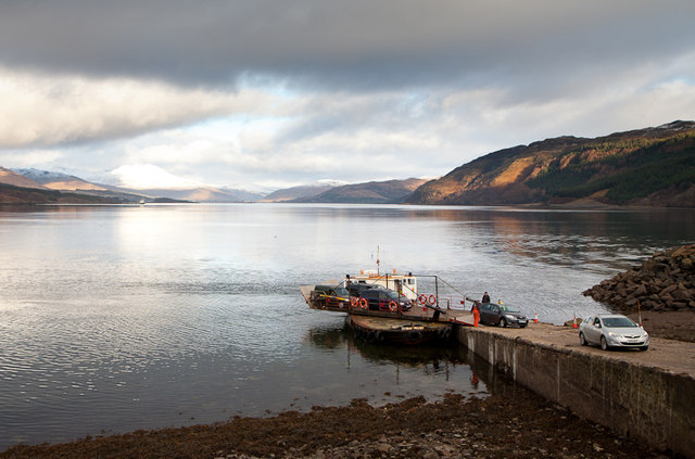
I remember watching an episode of the excellent TV series Coast in which one of the presenters - Neil Oliver I think - imparted the astonishing information that Scotland has 7,000 miles of coastline. Given that the British coastline totals around 11,000-12,000 miles (estimates vary), that is well over half. Looking at the west coast of Scotland it is easy to see where all these miles come from. Not only are there the numerous islands offshore, but this stretch of coast has the appearance of having been shredded, what with all the sea lochs which have formed around the mountainous terrain. One of the longest and widest of these is Loch Linnhe, which stretches for 31 miles from the Firth of Lorne to Fort William, where it hangs a left and turns into Loch Eil. Corran is at the narrowest part of Loch Linnhe, appropriately named The Narrows, and provides a ferry service to the eastern shore of The Narrows. The Tate website has a sketch by the artist Joseph Mallord William Turner depicting the Corran Narrows. Just above the ferry slipway is the Corran Lighthouse, a picturesque whitewash building with an adjoining lodge which offers self-catering accommodation. There is little else here apart from an inn, a scattering of houses and wonderful views up the loch.

Map of the area.

The Corran Ferry at Corran Narrows - geograph.org.uk - 107441. Photo by Norrie Adamson, via Wikimedia Commons.


Tuesday, 6 November 2012

LOCHALINE

The chunk of land to the south of Loch Sunart, which on the Ordnance Survey map is all contours and forests, is known as Morvern. The coast of Morvern is largely bereft of habitation, or even roads, until one reaches the tiny hamlets of Drimnin and Bunavullin on the Sound of Mull. A few miles further on, we finally hit an A road at Lochaline, which lies at the mouth of Loch Aline. Across Britain it is depressingly common to come across stories of once thriving mines which have since closed down - Strontian in the previous post is a case in point. However, in the case of Lochaline it was recently reported that a quartz sand mine which shut down in 2008 is reopening, with the restoration of 11 jobs provided by the mine. On a hillside above the village is Kiel Church, with the Old Session House to the east of the church displaying intricately carved grave slabs, while further grave slabs and celtic crosses can be found in the graveyard outside.

A bit further out, at the head of Loch Aline, Kinlochaline Castle with its 14th century tower is a former seat of the chiefs of Clan MacInnes, restored in the 19th century. The nearby ruined Adrtornish Castle is in the grounds of the Ardtornish Estate, famous for its gardens. Also in the estate is the Gothic Victorian mansion Ardtornish House, which offers self-catering accommodation. The Sound of Mull offers some of the best wreck diving in Britain, and there is a Dive Centre in Lochaline catering for this and other forms of diving.

Map of the area.

Lochaline from ferry. Photo by JMiall, via Wikimedia Commons.


Sunday, 4 November 2012

STRONTIAN

Strontian, which lies on an inlet off Loch Sunart, grew up around mining. During the 18th century there was a thriving lead mining enterprise here, and zinc, tin and silver were also mined. The village was created in order to provide accommodation for the miners, who at the peak of the extraction, around 1730, numbered 600. In the late 1700s French prisoners of war were working the mines, ironically producing lead for shot to be used in the war against France. It was during this time that another mineral was found which took its name from the village: strontium. The mining effort ended in the 1980s, by which time barite was being extracted for use in the North Sea oilfields. The decline of the village as the mining effort subsided reached the point, in 1968, where Strontian was included in a list of 2,000 dying Highland villages, and became the first of the villages to receive money for regeneration, resulting in a range of facilities including a shopping centre and a caravan and camping site. There is an interesting report in the Glasgow Herald from 1963 describing life in Strontian from the times when English "Landed Gentry" ruled the roost there, and discipline was such that whenever the laird and lady passed by the women had to curtsey and the men salute.

Map of the area.

Strontian, Strontian Jetty - geograph.org.uk - 921685. Photo by Chris Downer, via Wikimedia Commons.

Saturday, 3 November 2012

ARDNAMURCHAN

Ardnamurchan is a peninsula jutting out of the west coast of Scotland, so far west in fact that it includes the most westerly point on the UK mainland. The peninsula offers legendary sunsets and views across to some of the islands of the Inner Hebrides and, on a clear day, the Outer hebrides. The peninsula has been the scene of fierce battles in the past, including a Viking battle. Last year an extraordinary discovery was made at Port an Eilean Mhoir on the peninsula's north coast: a Viking boat burial site believed to be over 1,000 years old. The Viking whose body was found inside the boat is believed to have been a high-ranking warrior given the artefacts surrounding him. Ardnamurchan is home to a wide variety of wildlife, from deer to pine partens, otters to seals, and golden and white-tailed eagles. Activities available to visitors include sea kayaking, fishing, cycling and sailing. During the summer months wildlife watching boat trips and charters are on offer. The village of Kilchoan, towards the western end of the peninsula, is the most westerly village in the UK mainland and, although tiny, it provides a ferry service to Tobermory on Mull, operating out of a cute little ferry terminal with the appearance of a converted cottage. Nearby Mingary Castle was built in the 13th century and has seen plenty of action over the years, including a role in the Jacobite uprising, when the castle was used as a government garrison. The castle is now a restaurant with rooms.  Geologists will find the Kilchoan area of particular interest, as it was here that the minerals kilchoanite, dellaite and rustumite were first found, and there are also good examples of a type of igneous rock called a "cone sheet" to be found in the locality. Glenborrodale, on the south coast of the peninsula, has a castle which was formerly owned by Jesse Boot of Boots the Chemists fame.  There is also an RSPB reserve here.

Map of the area.

Kilchoan - geograph.org.uk - 354332. Photo by Stuart Wilding, via Wikimedia Commons.


Wednesday, 31 October 2012

LOCH NAN UAMH

Bonnie Prince Charlie has been popping up all over the place during my virtual meander around the Scottish coast, but few places can rival Loch Nan Uamh for the significance of their link to the Prince. It was here that Charles Edward Stuart landed at the start of the 1745 rebellion, and it was also here that he finally departed for France 14 months later after the ill-fated escapade was abandoned following the defeat at Culloden. There is a cave on the loch, below Arisaig House (now a hotel), where the Prince and his fellow fugitives hid from the English redcoats. There is a memorial cairn on the shore of the loch marking the spot where the Prince landed. Harking back to much earlier times, there is an Iron Age fort on a headland to the south; the fort is unusual in that the stones used to build it became "vitrified" probably due to intense heat from the accidental burning of the timber used to strengthen the walls. The other major feature of the loch, at its head, is the Gleann Mama Viaduct, built for the West Highland Railway and boasting eight arches. The viaduct provides passengers on the Jacobite, or "Harry Potter train" with wonderful views out over the loch and its beautiful shoreline.

Map of the area.

Loch nan Uamh - geograph.org.uk - 412224. Photo by Dave Fergusson, via Wikimedia Commons.


Monday, 15 October 2012

ARISAIG

Arisaig lies at the head of a sea loch called Loch nan Ceall, which is separated from the open sea by a jumble of rocks and tiny islands, making the loch a wonderfully tranquil stretch of water, ideal for sea kayaking; in fact the name actually means "the safe place". However, it has not always been this peaceful: in 1746 the loch was the scene of a fierce naval battle involving two French ships which turned up in the area to lend assistance to the Jacobites after the Battle of Culloden. The ships were caught by the Royal Navy, but they managed to escape, but not before offloading a hoard of gold being carried on board. The gold was then carried inland to Loch Arkaig, where it was hidden, but was subsequently lost.

As well as being on the A830 from Fort William, Arisaig is on the West Highland railway line, and is one of the stops on the Jacobite train journey (see Mallaig post). From April to September there are wildlife cruises from Arisaig to the nearby islands of Muck, Eigg and Rum, with opportunities to view creatures such as whales, otters and dolphins. Back in the village an old forge has been renovated and turned into the Land, Sea and Islands Visitor Centre, with displays on the social and natural history of the area. At nearby Barrahead is a lighthouse built by Thomas Stevenson, brother of Robert Louis. One of the people who worked on the lighthouse was one John Silver, who is believed to have been the inspiration for the Long John Silver character in Robert Louis Stevenson's famous novel Treasure Island.

Map of the area.

Arisaig - geograph.org.uk - 39503. Photo by Mick Garratt, via Wikimedia Commons.


Saturday, 13 October 2012

MORAR

In my post about Pennan I talked about the filming of Local Hero, which was focussed on the east coast village. However, fans of the film who want to visit the wonderful beaches featured in the film will be disappointed if they expect to find them in Pennan; they will need to head west to Morar and Arisaig, in particular Camusdarach Beach, which lies between the two. One of the most amusing scenes in the film was when the local populace gathered in the little church overlooking the beach to hold a meeting about the oil company's bid to exploit the area, while the oil men stood on the beach, oblivious to the line of people filing into the church. This scene was filmed at Morar, however as is so often the case in the movies all is not as it seems. The building used to depict the exterior of the church was actually a house dressed up to look ecclesiastical! The interior scenes were filmed in another location entirely. However, the shack occupied by Ben known as Ben's Shack was filmed in Morar, in the area between the sand dunes and a rocky promontory. Just to the east of the village of Morar is Loch Morar, which is home to Scotland's lesser known monster, a relative of Nessie called Morag. Legend has it that whenever Morag is sighted it heralds the death of a member of the local branch of the MacDonald clan. This area has also been used in the movies: scenes from Rob Roy were filmed here.

Map of the area.


File:Looking North up Camusdarach Beach - geograph.org.uk - 68305.jpg
Looking North up Camusdarach Beach - geograph.org.uk - 68305. Photo by David Crocker, via Wikimedia Commons.


Thursday, 11 October 2012

MALLAIG

Train buffs and Harry Potter fans alike will be delighted by a visit to Mallaig. The small port town is the terminus of what is generally considered to be one of the great railway journeys of the world, an 84-mile round trip between Mallaig and Fort William on the The Jacobite steam train. The Harry Potter connection arises from the fact that the route was that followed by the Hogwarts Express in the Harry Potter films, with some of the Jacobite's carriages being used in the filming. The train runs from May to October, however outside this period some of the magic can be captured on normal train services, since Mallaig is also the terminus of the West Highland Line. The arrival of the railway in Mallaig led to a rapid growth in the local economy and the population. Aside from its rail links, Mallaig is something of a hub for a number of ferry services, to Armadale in Skye, the islands of Rum, Eigg, Muck and Canna, and to Inverie in Knoydart. All this activity takes place against a backdrop of dramatic surrounding scenery and wonderful views over the Sound of Sleat to the Cuillin Hills on Skye. There is a Heritage Centre in the town with photographs and exhibits recalling the history of the locality.

Map of the area.

Mallaig Harbour - geograph.org.uk - 66439. Photo by Gordon Brown, via Wikimedia Commons.


Tuesday, 9 October 2012

KNOYDART PENINSULA

Knoydart is one of the wildest, least accessible parts of mainland Britain. The peninsula's 11 miles of road are not connected to the UK road network, meaning that the only way of getting to the peninsula is by sea or by means of a 16-mile walk over rough terrain. Even flying in is only an option by helicopter. The main sea route is from Mallaig to Knoydart's only village, Inverie. The ferry service which operates on this route is not only used by visitors to the peninsula, but provides a vital lifeline for the residents, bringing essential supplies to the village. Knoydart's past has been a turbulent one, marked by conflict between clans over control of the land and by forced evictions as part of the infamous Highland Clearances. In 1948 a group of men known as the "Seven Men of Knoydart" mounted a raid in an attempt to claim land for their own use, but the owner of the estate took the case to the Court of Session, and the claim was overturned. A subsequent appeal to the Secretary of State for Scotland was also rejected. There is a monument to the seven men in Inverie. Nowadays the preservation and development of Knoydart is looked after by the Knoydart Foundation, which bought the estate in 1999, ending years of conflict with private landlords. The estate is powered by a micro hydro-electric scheme operated by the Foundation. Inverie has a population of around 100 and its few amenities include Britain's remotest pub, The Old Forge Inn.

Map of the area.

Inverie Knoydart. Photo by Subarite, via Wikimedia Commons.


Sunday, 7 October 2012

GLENELG AND SANDAIG

Many towns and villages in Britain have twins in other countries, for example my home town of Penzance is twinned with Concarneau in Brittany. Glenelg, however, has gone one better by being twinned with a location on Mars! The space rover Curiosity is currently sending back images of a rocky valley which scientists have called Glenelg - although the name has been chosen for a geographical feature in Canada, rather than the Scottish Glenelg. Glenelg is a village located on the bay of the same name with views across to Skye. The village has a range of accommodation from the acclaimed Glenelg Inn to a campsite, and there is a summer ferry service between here and Skye. Just outside Glenelg lie the ruins of Bernera Barracks, built by the English after the Jacobite uprising. The barracks are fenced off for safety reasons. Near the village are the brochs, or Iron Age settlements, of Dun Troddan and Dun Telve. The latter is the best preserved broch in mainland Scotland, with a 10m external wall. Three and a half miles from Glenelg is Sandaig, where the author Gavin Maxwell lived with his otters. The house where he lived was sadly burnt down in 1968, but there are memorial stones to Maxwell himself and to his pet otter Edal.

Map of the area.

Old Dock, Glenelg - geograph.org.uk - 600932. Photo by sylvia duckworth, via Wikimedia Commons.


Saturday, 6 October 2012

EILEAN DONAN

I first set eyes on Eilean Donan on a driving holiday in Scotland, when we were on our way to make the crossing to Skye, and it was love at first sight. The name refers to the little island (eilean) of Donan, in Loch Duich, which is a continuation of Loch Alsh, but what makes it so special is the impossibly romantic castle perched on top of it. This must surely be one of the most photographed beauty spots in the whole of Scotland, so much so that anyone happening upon it for the first time is bound to experience a feeling of 'deja vu'. Sadly we didn't have time to visit the castle on that occasion, something I intend to rectify one day. For those who do make the time, it is open from March to October. The castle was originally built as protection against the Vikings, and over the years it evolved, reaching its maximum size in medieval times, but subsequently shrank, probably because less men were required to defend it. The castle's destruction came about during the Jacobite risings, but in the 20th century the island was bought by one Colonel John Macrae Gilstrap, who set about restoring the castle to its former glory, a task which was completed in 1932.

Not surprisingly, such a stunning location is bound to be popular with film-makers. Eilean Donan has made appearances in the James Bond film The World Is Not Enough, starring as the Castle Thane Headquarters of MI6, in Entrapment as the castle owned by Robert MacDougal (Sean Connery), in Highlander, Elizabeth: The Golden Age and Rob Roy, among others. In 2006 Eilan Donan castle was depicted in an unusual light, literally, when the artist Gerry Hofstetter illuminated the whole exterior of the castle with the Scottish flag, the Lion Rampant and the tartan of the clan MacRae.

Live streaming webcam view of the castle.

Map of the area.


Wednesday, 3 October 2012

BALMACARA

Hairy wood ants? That's a new one on me! Apparently these were recently found at the Balmacara Estate on the Lochalsh Peninsula, the furthest north and west these ants have ever been found in Scotland. The estate, an area of outstanding natural beauty covering 2,550 hectares, offers lochside woodland walks, interesting archaeological and historic features and the Balmacara Square Visitor Centre with guides to the footpaths and local information. The Lochalsh Woodland Garden contains an interesting mix of Scots Pine and other traditional woodland trees along with more exotic flora such as hydrangeas and rhododendrons, the latter best viewed in Spring. There are stunning views across to Skye from the garden.  As well as the Visitor Centre, the village of Balmacara Square has a number of picturesque, recently restored buildings and a range of accommodation options. Just beyond the western fringes of Balmacara is a monument to Donald Murchison, a Colonel in the Highland Army who defended Kintail and Lochalsh from 1715 to 1722 for his Jacobite chief, the exiled 5th Earl of Seaforth. Murchison risked life and limb by collecting rents on behalf of the Earl, and was imprisoned in the Tower of London. The monument, an obelisk, was erected many years later in 1863 by Murchison's great grand nephew Sir Roderick Murchison.

Map of the area.

Ard Hill across Balmacara Bay, Loch Alsh, Scotland - geograph.org.uk - 100933. Photo by Dave Napier, via Wikimedia Commons.


Monday, 3 September 2012

KYLE OF LOCHALSH

Many moons ago we set off on a driving tour around Scotland, and while we were there we decided to spend a short time on Skye. In those days there was no choice but to make the short crossing by ferry. All that has changed now, however, since the construction of a bridge connecting Kyle Of Lochalsh to the village of Kyleakin on Skye. The bridge, completed in 1995, used to charge a toll, which was a bone of contention among its users, but this has now been scrapped. It is still possible to reach Skye by ferry from the port of Mallaig a bit further south. Kyle's past as a ferry port began in 1819 with the arrival of the road from Inverness, when Kyle became the main departure point for Skye. When the railway arrived in 1897 a ferry service to Stornoway started up, although this ended in 1973, when the service moved to Ullapool. Now that the bridge has replaced the ferries, a lot of people whizz straight through without stopping, which is a shame because it is an attractive little harbour town with wonderful views across to Skye, while among the activities on offer are glass-bottom boat trips.

Webcam view of the bridge.

Map of the area.

Jetty, Kyle of Lochalsh - geograph.org.uk - 1706767. Photo by JThomas, via Wikimedia Commons.


Sunday, 2 September 2012

PLOCKTON

The 'Plock' in Plockton derives from the Gaelic word 'ploc' which means a "lumpish promontory". The promontory in question is at the seaward end of Loch Carron, on which this picturesque village stands, looking improbably riviera-esque due to the palm trees which are allowed to thrive here thanks to the North Atlantic Drift. With its idyllic setting, looking out on a landscape of mountains, islands, heather and pine trees, the village is, not surprisingly, a magnet for artists. Just across the way from the village is Duncraig Castle, which was built by the Matheson family from the proceeds of trading activities in China. The castle is currently being renovated, but when the renovations are completed next year it will offer elegant guest accommodation.

Plockton may be recognised by many as the backdrop for the beat of TV cop Hamish Macbeth. The TV series led to a surge in popularity due to the numbers of fans of the series visiting the village. However, as is so often the case, this phenomenon has led to a sharp rise in property prices in the locality. According to a report by scotsman.com in 2002, both well-heeled British people and Americans were offering well over market price for houses in the area, placing them beyond the reach of most locals, and a recent survey had revealed that over a third of homes here were owned by outsiders and being used as holiday homes. Coming from Cornwall, I can sympathise with the plight of the local residents.

Map of the area.


Thursday, 30 August 2012

STROMEFERRY

A small, idyllic settlement on the west coast of Scotland seems an unlikely venue for a riot, but this is exactly what happened one Sunday in 1883 when over 200 fishermen, enraged by the Highland Railway Company's disrespectful attitude towards the Sabbath in continuing to run a Sunday train service, converged on the railway terminus to prevent the unloading of fish bound for London. The local constabulary proved unequal to the task of quelling the riot judging by newspaper reports of the time: "...the chief constable of Rosshire arrived from Dingwall with six policemen - all the force he could muster"...."Sticks were freely used by the fishermen, and the chief constable himself and two of his men got some hard knocks". Further unrest ensued at a later date, this time with the women weighing in: "...the women filled their aprons with stones, with which they pelted the constables so vigorously that they had to retreat".* 10 men ended up in prison and the subject was debated in the House of Commons, which maintained that there was no law preventing Sunday traffic in Scotland.

Thankfully, such events are but a distant memory in this village on the south shore of Loch Carron. The railway still operates, unimpeded by angry locals, although the ferry across the loch to North Strome which gave rise to the name of the village ceased operating in 1970. Earlier this year a temporary ferry service had to be hastily rustled up after the A890 road was blocked by a series of rockfalls. Without this temporary service, a 140-mile detour via Inverness on the east coast would have been the order of the day! The village is surrounded by woodland, and there is a pleasant circular route through the woods which takes in lovely views of the loch and mountains.

* From a report by the Edinburgh correspondent of the Otago Daily Times.

Map of the area.

Stromeferry ferry 2012 - geograph.org.uk - 2808301. Photo by Roy Tait, via Wikimedia Commons.


Tuesday, 28 August 2012

ATTADALE

Like Poolewe further to the north, Attadale has a treat in store for garden lovers, in the form of the fabulous Attadale Gardens, a colourful 20 acres of rhododendrons, Himalayan primula and other exotic plants set in a beautiful location with lovely views across the loch, with the peaks of Skye visible in the distance.  The gardens, which also feature a sculpture collection, form part of a 30,000 acre estate belonging originally to the Clan Matheson, with as its focal point a house built in 1755. Fans of the TV series Hamish Macbeth may experience a deja vu moment when visiting the house, as it was used in the series. There is not a lot more to Attadale, but it does have a tiny railway station, being on the Inverness-Kyle of Lochalsh railway line.

Map of the area.


File:Attadale House and Gardens by Loch Carron - geograph.org.uk - 68846.jpg
Attadale House and Gardens by Loch Carron - geograph.org.uk - 68846. Photo by David Crocker, via Wikimedia Commons.


Sunday, 26 August 2012

LOCHCARRON

One of the many legends and mysteries around the coast of Scotland concerns a wise woman who lived at the head of Loch Carron. Such were her powers of healing that a person only had to present her with a piece of clothing belonging to the sick individual, which she would work her magic on, resulting in a miraculous recovery. However, there was an unfortunate side effect for the woman, who herself became very ill for several days afterwards. People came from miles around to avail themselves of her services.

The village of Lochcarron, which lies strung out on the shores of the loch, started out as a much smaller settlement known as Janetown, but it grew dramatically in size due to the arrival of people displaced by the Highland Clearances. The area to the north of the village, known as Kirkton, is the location of a small, whitewash church built in 1883, and there is also a ruined church and graveyard dating from 1751. Walking is a favourite activity around here, as well as wildlife watching, with plenty of opportunities to combine the two. Otters, pine martens and deer are just some of the creatures the patient walker might encounter.


Map
of the area.

Lochcarron - geograph.org.uk - 8142. Photo by Anne Burgess, via Wikimedia Commons.