Labels

Aberdeenshire (21) Angus (4) antiquities (87) Argyll and Bute (35) Arran (7) art (37) birds (231) bridge (9) Caithness (12) Carmarthenshire (5) castle (164) Ceredigion (9) Channel Islands (13) Cheshire West and Cheshire (1) City and County of Swansea (1) City of Bristol (2) City of Edinburgh (4) Conwy (8) Cornwall (74) County Antrim (19) County Down (23) County Durham (3) County Londonderry (4) Cumbria (19) Denbighshire (2) Devon (48) diving (9) Dorset (18) Dumfries and Galloway (22) Dundee City (1) East Lothian (6) East Sussex (16) East Yorkshire (6) English Riviera (3) Essex (17) Fife (19) Flintshire (1) food (12) fossils (14) gardens (28) Ghosts (36) Glamorgan (1) Gower (7) Guernsey (4) Gwent (1) Gwynedd (19) Hampshire (13) Highland (72) Inner Hebrides (42) Inverclyde (5) Islay (8) Isle of Anglesey (14) Isle Of Man (7) Isle Of Wight (10) Isles of Scilly (3) Jersey (7) Kent (22) Lancashire (8) Lewis and Harris (7) lighthouse (62) Lincolnshire (8) Merseyside (8) Mid Glamorgan (1) mining (23) Moray (10) Mull (8) Norfolk (21) North Ayrshire (13) North Yorkshire (12) Northern Ireland (45) Northumberland (17) Orkney (10) Outer Hebrides (14) Pembrokeshire (27) pubs (50) Ross and Cromarty (20) Scotland (299) Scottish Borders (3) Shetland (14) shipwrecks (42) Skye (12) smuggling (48) Somerset (9) South Ayrshire (6) South Glamorgan (5) South Gloucestershire (2) Suffolk (18) surfing (92) Sutherland (16) Tyne and Wear (8) Wales (93) wartime (75) webcams (232) West Dunbartonshire (3) West Glamorgan (9) West Sussex (9)
Showing posts with label East Sussex. Show all posts

Thursday, 16 June 2011

CAMBER

Much of the East Sussex coast so far has been characterised by shingle beaches, but at Camber these are replaced by a proper sand beach, and not only that but it is one of very few places in the South East with sand dunes. This spot is described in the local tourist brochure as “the perfect place for Kite Surfing, Kite Buggies and Kite Land Boarding”. For golfers, the Rye Golf Club lies a short distance inland.

The village of Camber is very close to the dunes, but is prevented from going under by a combination of marram grass and traditional chestnut fences. This environment is a haven for wildlife and a variety of plants as well as for kite enthusiasts. But mind how you go here. A spiky shrub called sea buckthorn is fodder for the brown-tail moth caterpillar, a hairy little beast which can inflict a nasty rash if inadvertently touched. A further hazard lurking here comes courtesy of the black nightshade, which has poisonous black berries, and if that is not enough to leave you cowering behind the dunes, there is a fish which lives on the sandy sea bed called the weever fish which can deliver up a nasty sting if trodden on while paddling. On a more pleasant note, up above the dunes, the skylark provides a tuneful backdrop, making this a delightful place to visit.

In the 1950s Camber was chosen as one of three “penetration points” to be tested as potential sites for nudists, causing a deal of consternation among the residents. One feisty local told the press that “I’m thinking it’s a whiff of buck shot they will be getting if they try anything in Camber”. This threat evidently did not have the desired effect, because according to the “Naturist UK Fact File” website, the remoter parts of Camber Sands have long been used by naturists. Continuing the saucy theme, Camber Sands was used in the filming of the Carry On film “Carry On – Follow That Camel”.

Map of the area.

Camber Sands - geograph.org.uk - 1427677. Photo by Chris Whippet, via Wikimedia Commons


Wednesday, 15 June 2011

RYE

Rye is another former port which has been left high and dry; due to the receding of the sea it now lies two miles inland. The town sits on a hill and is a charming tangle of winding cobbled streets populated by half-timbered and Georgian houses. The town’s 13th century defences, of which Ypres Tower remains and is now a museum of local history, failed to protect it from the ravages of the French, who burned most of the town down in 1377, following which several of the town’s leaders were hanged for “faintheartedness”. Lamb House, run by the National Trust, was built in the 18th century by the prominent Lamb family, and was occupied by the novelist Henry James before the First World War. The Lamb family were victims of a murder in 1743 when a local butcher and innkeeper called Breads killed James Lamb’s brother-in-law, believing him to be James himself. Breads then went on a drunken rampage shouting “Butchers should kill lambs!”. He was hanged for his crime, and his skull is now kept in the town hall.

Rye has a number of lovely old inns, many of which were bound up in the smuggling trade, but the most famous of them all is the Mermaid Inn. Not surprisingly, there are a number of ghost stories associated with this inn, one of which concerns a haunting alleged to take place each year on 29 October. Two ladies once slept in the room concerned to see if they would witness anything, and one of them stayed awake long enough to observe two men dressed in doublet and hose fighting a duel. The winner of the duel then tossed his opponent’s body down a shaft in the corner of the room. However, the lady who witnessed this subsequently noted that the shaft had long since been sealed up.

For events in Rye see here.

Map of the area.

File:Ivyinn1219129.jpg
Ivyinn1219129. Photo by Richard Rogerson, via Wikimedia Commons


Tuesday, 14 June 2011

WINCHELSEA

The village of Winchelsea, or town as claimed by some, was a prosperous port during the Middle Ages, in fact it was one of the Cinque Ports, but the town was moved inland on the orders of Edward I in 1281, although it retained its Cinque Port credentials. The port waned in importance partly due to becoming silted up and partly due to the ravages of the Hundred Years War when it suffered repeated attacks by the Spanish and French. Several remnants of Winchelsea’s medieval past remain, including three of the original gateways and the choir and side chapels of the original Church of St Thomas the Martyr, which suffered badly at the hands of the French but has since been rebuilt. One of the gates features in a painting by William Holman Hunt called “The City Gate, Winchelsea”, one of a series of paintings he did while visiting the area. Another painting called “The Blind Girl” by J. E. Millais depicts the ivy-clad church.

If you want to discover more about the role of Winchelsea in the Confederation of Cinque Ports as well as the history of the town, you can do so in the Winchelsea Court Hall Museum. Beachgoers will find a beach of shingle with low-tide sand which is popular with caravanners and campers. Between Winchelsea and Rye is Camber Castle, one of a defensive chain built by Henry VIII in the 1530s as a response to the threat from those pesky French.

Map of the area.


File:Winchelsea, Grey Friars ruins.jpg
Winchelsea, Grey Friars ruins. Photo by Michael Coppins, via Wikimedia Commons

Monday, 13 June 2011

PETT LEVEL

Pett lies at one end of a canal called the Royal Military Canal, the other end being near Hythe, Kent. It was built, bizarrely, with the aim of fending off Napoleon’s army, although only an optimist of the highest order would have believed that a mere canal could defend the country against such a formidable fighting force. The cliffs between Hastings and Pett Level contain many fossils as well as the remains of ancient woodland, and a walk out to Cliff End at low tide is rewarded with the sight of ancient tree stumps sticking out of the water. In the sea off Pett Level lies the wreck of the gun ship Anne, built for Charles II and launched in 1678 but lost to the Battle of Beachy Head in 1690. A survey carried out in the 1970s discovered that the hull was still reasonably intact, and in fact she is still visible at low tide.

Map of the area.

File:Coast path, Pett Level Road, Near Rye - panoramio (5).jpg
Coast path, Pett Level Road, near Rye - panoramio(5). Photo by J J Jones, via Wikimedia Commons


Sunday, 12 June 2011

FAIRLIGHT

The cliffs on this section of the Sussex coast are a mixture of sandstone and clay, and are so prone to erosion that the cliff edge at Fairlight is receding at the rate of 25 metres a year, threatening the homes and gardens of the mainly retired residents. A newspaper report from 2004 described how the villagers were locked in battle with English Nature, which was reluctant to allow any defences to be built on the site because as it happens Fairlight sits on top of one of Britain’s most important dinosaur fossil sites, housing the 135-million-year-old remains of crocodile, pterosaurs and dinosaur footprints. The erosion of the cliff face allows easy access to these treasures. The country park here is characterised by the hills known as Firehills, which may have been so called because of the yellow gorse which covers them in Spring, or alternatively due to the fact that at the turn of the century the area was used for practice firings by the local gun battery. The downs around here were captured on canvas by William Holman Hunt in his painting Fairlight Downs, Sunlight On The Sea.

Map of the area.

Fairlight fire hills. Photo by Colin Smith, via Wikimedia Commons


Saturday, 11 June 2011

HASTINGS

The name Hastings is synonymous with one of the most famous events in British history: the Battle of Hastings, which took place after William the Conqueror led his army to Hastings after landing at Pevensey, and resulted in King Harold being killed by a shot in the eye with an arrow. The battle actually took place in a field just outside the nearby town of Battle, but in Hastings the remains of a Norman castle still stand as a reminder of this time. Hastings was one of five coastal towns designated as the Confederation of Cinque Ports, established by royal charter in 1155 to provide ships for the use of the Crown, and also for trade purposes.

In view of its distinguished past, it seems a shame that Hastings has latterly acquired a reputation as being a bit shabby and run-down. The town has all the ingredients for a charming seaside venue, with fishing boats drawn up onto the shingle beach, where a type of huts called “deezes” or “net shops” used for storing fishermen’s nets add a picturesque touch, an old town nestled in a valley between the cliffs of the West Hill and East Hill, and a cliff railway whisking people up to the castle, where there is a 1066 exhibition. There are also some caves called St Clement’s Caves with a visitor attraction called The Smugglers Adventure. Other attractions include the Blue Reef Aquarium and, of course, the pier.

For events in Hastings see here.

Live streaming webcam view of the pier and the English Channel.

Map of the area.

File:Hasting, net shops.JPG
Hasting, net shops. Photo by Dominik Tefert, via Wikimedia Commons

ST LEONARDS-ON-SEA

St Leonards-On-Sea is right next door to Hastings, but does not share the latter’s rich history, being relatively new. It was the developer-architect father-and-son team James and Decimus Burton who came up with the scheme for a new resort, and carried it through during the period 1928-34. This talented duo had already worked their magic in parts of London such as Marylebone and Belgravia, and looking at some of the grander terraces and squares in St Leonards one can see the similarity. A different style of architecture can be found on the seafront in the form of the Art Deco apartment block Marine Court, which was probably considered sleek and modern in its day but now lowers the tone set against the aforementioned elegance. Better to tear your eyes away from this behemoth and enjoy the stunning views towards Beachy Head. St Leonards has a nice bohemian air about it, with interesting, quirky shops and art galleries. The town used to have a posh school called Summerfields, and one of the pupils there was Prince Rainier of Monaco, but the school closed in 1966.

Probably the biggest issue facing Britain today is mass immigration and the flood of asylum seekers coming to Britain looking for a better life, and St Leonards has had its share of controversy over this issue. In 2005 during the Blair years, when immigration really started to become an inflammatory subject, there was a newspaper report about a building in St Leonards called the Adelphi Hotel which was housing over 200 asylum seekers, much to the disgust of the locals, who claimed to have seen some of them driving around in new cars and wearing expensive clothes. Immigration reared its head again in news reports about the town in 2010, when the vicar of St Peter and St Paul in St Leonards was convicted of conducting hundreds of sham marriages between East Europeans and Africans, the former earning up to £3,000 each for their part in the sham.

Map of the area.

File:The beach at St Leonards on Sea - geograph.org.uk - 527090.jpg
The beach at St Leonards On Sea - geograph.org.uk - 527090. Photo by Simon Richardson, via Wikimedia Commons


Thursday, 9 June 2011

BEXHILL-ON-SEA

Bexhill is one of those south coast towns favoured by the older generation, and has a reputation for being a bit sleepy, especially after dark. However, as with many such places, efforts are being made to drag the town kicking and screaming into the 21st century, in Bexhill’s case courtesy of the restoration of a 1930s architectural masterpiece, and its conversion into a swanky arts venue. The building in question is the De La Warr Pavilion, built in 1935 for the 9th Earl De La Warr. The Pavilion was the country’s first public building built in the Modernist style. There is also a cafe described as a “beach on the roof” and a sophisticated restaurant.

The Edwardian period, when Bexhill became a playground for the aristocracy, was an important time for the town, and it was during this period that Bexhill witnessed two events which put it in the vanguard of English resorts. In 1901, Bexhill was one of the first resorts in Britain to allow mixed bathing, and the following year the town hosted the country’s first ever motor race, causing it to be thought of evermore as the spiritual birthplace of British Motor Racing. Back in the present, and following on from the Pavilion’s regeneration, the New Wave project is now underway, an ambitious plan to update and beautify the town’s seafront. However, the project has been met with a mixed reception from the locals, and a recent edition of the local paper included a report about furious local residents fed up with the dust being chucked around the place by the construction activities, getting into every nook and cranny of peoples’ balconies, and even inside their properties. One lady complained of knee-deep sand on her balcony, adding “It looks a bit like the Sahara desert”. Oh well, no gain without pain as they say. 

Live streaming webcam view from Bexhill Sailing Club.

Map of the area.


File:The Beach at Bexhill - geograph.org.uk - 295353.jpg
The beach at Bexhill - geograph.org.uk - 295353. Photo by Nigel Stickells, via Wikimedia Commons

Wednesday, 8 June 2011

PEVENSEY BAY

Pevensey Bay’s place in history was assured in 1066 when it was used as the landing place for William The Conquerer who, taking advantage of the fact that King Harold was otherwise engaged in fighting an invasion in the north, leaving this part of the British coast relatively defenceless, arrived here with the intention of laying claim to the English crown. Another chapter in the history of Pevensey remains in the form of Pevensey Castle, whose outer walls were built by the Romans as a defence against Saxon invaders.

The village of Pevensey, a short distance inland, was given short shrift in a description published in 1844 in “The Cottager’s friend, and guide of the young”: “It was once formidable for its castle, and useful for its harbour; but is now a mere village, with three or four hundred inhabitants, a choked-up port, and a castle in ruins.” In fact, the marshes surrounding the village are an undisturbed home for wildlife, and the Pevensey Marshes Nature Reserve where birds to look out for include wigeon and teal during the winter, short-eared owl, hen harrier and redshank, as well as insects such as the fen raft spider.  The village itself has some charming old buildings and a haunted pub dating from 1527 called the Royal Oak and Castle, where phantom footsteps and the unexplained smell of perfume have been experienced.  There have also been fun and games in a particular room where occupants have experienced weight on their legs and the sense of the duvet being pulled back.

Map of the area.


File:Pevensey Bay looking east towards Normans Bay - geograph.org.uk - 1093697.jpg
Pevensey Bay looking east towards Normans Bay - geograph.org.uk - 1093697. Photo by Kevin Gordon, via Wikimedia Commons


Tuesday, 7 June 2011

EASTBOURNE

Eastbourne, with its promenade and pier and rows of seafront hotels, has, like Bognor Regis, long suffered a bit of an image problem. The town has rather cruelly been referred to as “God’s waiting room” for the number of elderly visitors frequenting the resort. However recent developments suggest that Eastbourne is reinventing itself and is rapidly turning into a hip venue to rival its near neighbour, Brighton. Recent additions to the town’s attractions include a great new art gallery called the Towner with a cafe on the top floor offering fantastic views.  Add to this a host of new restaurants, several theatres and museums, and a quarter named Little Chelsea stuffed with antiques shops, boutiques and galleries, and one can safely say that while there is still plenty to keep the older generation happy, there is no longer any reason for the young ones to stay away. One of Eastbourne’s big events of the year is the tennis tournament that takes place there each year shortly before Wimbledon. The tournament, which was originally women only, but opened to men in 2009, takes place on grass courts and gives fans a chance to see how their favourite players are doing in the run up to Wimbledon.

Eastbourne was traditionally a favoured retreat for rich widows, and in the mid-1950s there was an investigation into the deaths of 300 of these wealthy widows sparked by an anonymous letter suggesting that the women were the victims of a fraudster. During the investigation, bodies were exhumed and more than 400 wills were examined. The Leader-Post reported that the women may have “fallen under the spell of a man with hypnotic powers”, in fact a hypnotist was questioned during the course of the police investigations. In 1957 the trial took place of an Irish-born GP suspected of persuading wealthy widows to leave him money in their wills, and he was found not guilty, but was eventually convicted for forging of prescriptions, false statements and other misdemeanours. Unbelievably, he was later allowed to resume his work as a general practitioner in Eastbourne. There is a school of thought that the deaths were acts of euthanasia rather than any attempt on the part of the doctor to profit from the wills of the ladies in question. However, others regard him as the forerunner of the latter-day mass murderer Harold Shipman.

For a list of events in Eastbourne, see here.

Live streaming webcam view of the pier.

Map of the area.

File:Eastbourne beach - geograph.org.uk - 1396094.jpg
Eastbourne beach - geograph.org.uk - 1396094. Photo by Raymond Knapman, via Wikimedia Commons

Monday, 6 June 2011

SEVEN SISTERS AND BEACHY HEAD

The stretch of coast just before Eastbourne boasts the neighbouring topographical superstars The Seven Sisters and Beachy Head. The Seven Sisters are essentially a series of seven ‘humps’ on the clifftop, with its striking white chalk face topped with rolling green downland. They came about as a result of the erosion of dry valleys within the downs. There is a country park here taking in the cliffs, river valleys and chalk grassland stretching over 280 hectares.

Beachy Head is one of the most famous headlands on Britain’s south coast, with the highest chalk sea cliff in the country, rising to a height of 162m. This is a place tinged with sadness, being a popular place for suicides and attempted suicides, reckoned to number on average 20 per year. Add to that the loss of life from maritime accidents just offshore, and one shudders to think of the number of lives lost at the hands of Beachy Head. A collision in 1889 between the British vessel Largo Bay and a steamer called the Glencoe resulted in 54 dead, more than half of them Chinese. In 1912 the P & O liner Oceana collided with the German barque Pisagua resulting in 9 lost lives. These are just two examples. Add to this the wartime toll, including the torpedoing of the steamer Haipolian in 1915, and it is hard to conjure up positive feelings about this headland. However, as long as you are not harbouring self-annihilating thoughts, a walk up to Beachy Head can be one of the most exhilarating experiences to be had on the British coast.

Map of the area.

File:Beachy Head (2205).jpg
Beachy Head (2204). Photo by Nilfanion, via Wikimedia Commons

SEAFORD

Seaford has a long history stretching back to at least Roman times. The remains of Roman villas have been found in the locality, a reminder that there was once a Roman station here, and that there was a large Roman camp on the hill above the town. Moving forward to Saxon times, King Alfred The Great had a palace at nearby West Dean, and it is thought he used the area as a base for his fleet in his quest to mount a defence against the Vikings. Seaford subsequently became an important trading port, for exporting wool and importing wine. However, the combined evils of the Hundred Years War and the Black Death led to a serious decline. Nowadays, Seaford is a quiet coastal town whose attractions include the view eastwards towards the Seven Sisters. One of the best places for viewing them is Cuckmere Haven at the mouth of the Cuckmere Valley, an area of downland within the Seven Sisters Country Park which is looked after by the National Trust and visited by a wide variety of birds and over-wintering wildfowl. There is also an array of marine life to be found in the rock pools of Cuckmere Haven.

Map of the area.

File:Seaford beach, East Sussex (2003).jpg
Seaford beach, East Sussex (2003). Photo by Peter Jordan, via Wikimedia Commons


Saturday, 4 June 2011

PEACEHAVEN AND NEWHAVEN

It is one of life’s ironies that the serene-sounding name of Peacehaven came about as a result of a wartime campaign. The settlement, begun in 1914 by Charles Neville, was originally named New Anzac-On-Sea following a competition in the Daily Express to come up with a name. However, the Gallipoli campaign got underway soon after, and this traumatic event forced a rethink, leading to the renaming of the town as Peacehaven. A glance at the map of the town calls to mind a typical American urban space, being laid out in a grid pattern. Some of the original dwellings were decidedly makeshift, making use of railway carriages and army huts. In the early 1920s there was a attempt to inject some glamour into the town with the building of the Peacehaven Hotel, an ornate affair with an opening party whose guests included minor royalty. Sadly, this has since been demolished.

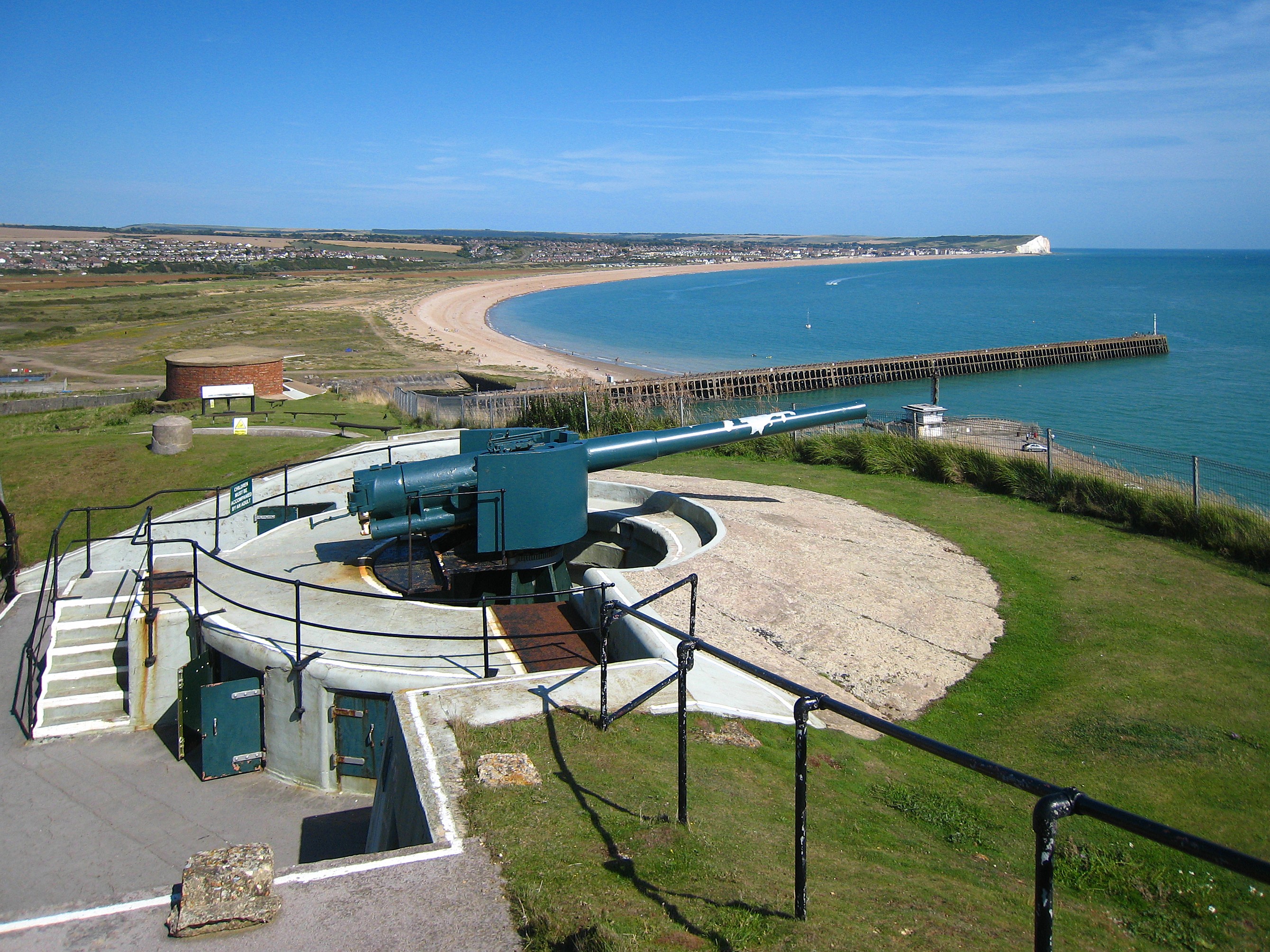
Just to the east of Peacehaven, and at the mouth of the River Ouse, the port of Newhaven boasts ferry connections to Le Havre and Dieppe in France. A more belligerent crossing to Dieppe took place in 1942 involving a number of ports including Newhaven when a largely Canadian force mounted a raid on Dieppe. The raid exacted a heavy toll on the Canadian contingent, leaving 907 dead. The port at Newhaven also played a vital role in the transport of men and supplies during the First World War. Further back in time, in 1848 Newhaven was the landing-place of Louis Philippe, the exiled French king, who crossed the channel in a fishing boat with his queen, travelling under the pseudonym Mr and Mrs Smith. Newhaven Fort, one of a series of forts known as the Palmerston Forts, is open to visitors as a museum.

For a list of events in the area, see here.

Live webcam view.

Map of the area.


File:Newhaven Fort.jpg
Newhaven Fort. Photo by Michael Coppins, via Wikimedia Commons


Friday, 3 June 2011

SALTDEAN

It was in the 1930s, when shorter working hours and paid holidays brought an increase in leisure time, that swimming and sunbathing became popular summertime activities, so it is no coincidence that many of the country’s outdoor swimming pools, or lidos, date from that period, characterised by the simple, linear symmetry of the Art Deco style. The lido at Saltdean is a classic example of the genre, developed in the 1930s, and promoted as “The Coming Resort”. Many of the country’s lidos sadly closed down as tastes changed and attendance fell, but the lido at Saltdean is still up and running. Last year, however, the Lido’s future was threatened by a plan to fill it in and build 102 flats over it. This plan was fought by the Save Saltdean Lido Campaign being run by the Friends of Saltdean Lido. Lets hope they succeed in their quest to preserve this Art Deco gem. For those preferring to swim in the sea, the beach at Saltdean is shingle backed by chalk cliffs, and there are rock pools at low tide.  (Postscript: I am happy to report that in 2018 the lido is still going.  Well done to the campaign.)

Another Art Deco masterpiece which has been turned into flats is the former Grand Ocean Hotel, whose guests in its heyday included Bette Davis. The hotel was designed by Richard Jones, who also designed the Lido, and opened in 1938. The holiday camp entrepreneur Billy Butlin bought the site in 1953 for £250,000, and one of the redcoats working there was Jimmy Tarbuck, who was later destined to carve out a career as a well-known comedian. However, the advent of holidays to sun-soaked continental destinations brought about a decline to such places and the Grand finally closed in 2005.

Map of the area.

File:Saltdean Lido - geograph.org.uk - 634728.jpg
Saltdean Lido - geograph.org.uk - 634728. Photo by Simon Carey, via Wikimedia Commons


ROTTINGDEAN

Rottingdean is a village just to the east of Brighton, but which comes under the Brighton and Hove administrative area. In the 18th and early 19th centuries the village was a hive of smuggling activity, the contraband being stored in a maze of underground cellars below the High Street. Rottingdean’s most prominent landmark is the old windmill located high above the village on Beacon Hill, so named because it was here that a beacon was lit to warn of the approaching Spanish Armada. The mill dates from 1802, and continued to grind corn until 1881. It is now looked after by the local Preservation Society.

Probably the most famous resident of Rottingdean was the writer Rudyard Kipling, who moved there with his uncle the painter Sir Edward Burne-Jones in 1897. It was there that he wrote one of his most famous works, the Just So Stories. He also wrote “A Smuggler’s Song” after moving away from the village, which was probably inspired by the aforementioned smuggling trade. His old house is adjacent to the gardens named after him, Kipling Gardens. It appears he had a rocky relationship with his neighbours. In 1902 the Sunday Vindicator reported that Rottingdean residents were outraged when Kipling’s aunt displayed a pro-Boer banner, which “provoked a tumultuous assemblage of the villagers”, who were met by Kipling with “the use of sundry forceful expletives”. This incident made him so unpopular with the locals that he moved to a new home near Tunbridge Wells, making the excuse that he was fed up with the large numbers of his fans descending on him in Rottingdean.

Map of the area.

File:Beach Huts, Rottingdean - geograph.org.uk - 227900.jpg
Beach Huts, Rottingdean - geograph.org,uk - 227900. Photo by David Eldridge, via Wikimedia Commons


Wednesday, 1 June 2011

BRIGHTON AND HOVE

Brighton, which played a starring role in the 1938 novel Brighton Rock by Graham Greene, is undoubtedly the main rival to Bournemouth for the title of premier south coast resort. It has been described as London-on-sea, due to its relative proximity to the capital. Brighton and the adjoining resort of Hove are essentially one big community, named Brighton and Hove for administrative purposes. The resort used to have two piers, but one of them, the West Pier, burned down in 2003. It subsequently remained in situ, looking rather sad, but there are now plans to install a glamorous new attraction at the site, namely the i360, described as “a slender, elegant observation tower” capable of elevating its passengers to a height of 150 meters above sea level, giving panoramic views of the seafront. The other pier, the Palace Pier, remains in place in spite of having endured a number of mishaps over the years, including an attempted IRA bomb attack in 1994. Viewed from the Palace Pier, Brighton has a slightly depressing high-rise appearance, but behind this modern facade there is a charming labyrinth of streets dating from an earlier age called The Lanes, offering an array of smart little shops, restaurants and pubs. Brighton has a thriving gay community, and each summer there is a massive Gay Pride parade.

Just to the east of the Lanes is Brighton’s most famous land was built to look like an Indian palace, and looks comically incongruous with itsmark, which looks as though it belongs not only to a different age, but to a far-flung country. The Brighton Royal Pavilion was built to look like an Indian palace, and looks comically incongruous with its riot of domes and other exotic Indian features. It houses one of the finest collections of chinoiserie in Britain. It was built by John Nash as a seaside home for the Prince Regent, George, Prince of Wales, later King George IV, and construction commenced in 1787.

In the late 1800s, Magnus Volk, son of a German clockmaker, who was born in Brighton, built a tourist attraction which was a rival in eccentricity even for the Pavilion. Nicknamed the “Daddy Longlegs”, it was a “Seashore Electric Tramroad” consisting of a vehicle with 24-foot long legs, each with four wheels on the end, with two open decks, which could carry up to 150 passengers for 3 miles along the seafront to neighbouring Rottingdean. It was powered by electric cables which ran along a row of wooden poles. Sadly, this bizarre example of 19th century inventiveness was destroyed by a severe storm one week after opening, although it was rebuilt, only to close again in 1910. One of Volk’s earlier projects, however, was much more long-lived, in fact it still runs today. August 1883 saw the opening of Volk’s Electric Railway, the world’s first public electric railway. During the summer months it is possible to travel on this eminent piece of engineering from the Aquarium to Black Rock.  Just beyond the latter is the Marina with an array of shops and restaurants.

Brighton Festival, one of the country’s biggest and most well-established arts festivals, takes place in early summer each year. For other events, see here.

Live streaming webcam view of the pier.

Map of the area.

File:Brighton, The Palace Pier - geograph.org.uk - 869745.jpg
Brighton, The Palace Pier - geograph.org.uk - 869745. Photo by Martyn Gorman, via Wikimedia Commons