Labels

Aberdeenshire (21) Angus (4) antiquities (87) Argyll and Bute (35) Arran (7) art (37) birds (231) bridge (9) Caithness (12) Carmarthenshire (5) castle (164) Ceredigion (9) Channel Islands (13) Cheshire West and Cheshire (1) City and County of Swansea (1) City of Bristol (2) City of Edinburgh (4) Conwy (8) Cornwall (74) County Antrim (19) County Down (23) County Durham (3) County Londonderry (4) Cumbria (19) Denbighshire (2) Devon (48) diving (9) Dorset (18) Dumfries and Galloway (22) Dundee City (1) East Lothian (6) East Sussex (16) East Yorkshire (6) English Riviera (3) Essex (17) Fife (19) Flintshire (1) food (12) fossils (14) gardens (28) Ghosts (36) Glamorgan (1) Gower (7) Guernsey (4) Gwent (1) Gwynedd (19) Hampshire (13) Highland (72) Inner Hebrides (42) Inverclyde (5) Islay (8) Isle of Anglesey (14) Isle Of Man (7) Isle Of Wight (10) Isles of Scilly (3) Jersey (7) Kent (22) Lancashire (8) Lewis and Harris (7) lighthouse (62) Lincolnshire (8) Merseyside (8) Mid Glamorgan (1) mining (23) Moray (10) Mull (8) Norfolk (21) North Ayrshire (13) North Yorkshire (12) Northern Ireland (45) Northumberland (17) Orkney (10) Outer Hebrides (14) Pembrokeshire (27) pubs (50) Ross and Cromarty (20) Scotland (299) Scottish Borders (3) Shetland (14) shipwrecks (42) Skye (12) smuggling (48) Somerset (9) South Ayrshire (6) South Glamorgan (5) South Gloucestershire (2) Suffolk (18) surfing (92) Sutherland (16) Tyne and Wear (8) Wales (93) wartime (75) webcams (232) West Dunbartonshire (3) West Glamorgan (9) West Sussex (9)
Showing posts with label wartime. Show all posts

Tuesday, 16 January 2018

CARNLOUGH


Continuing north from Glenarm along the glorious coast road which hugs the Antrim shore, we come to Carnlough (‘cairn of the lake’), a village on the bay of the same name and lying at the mouth of Glencloy.  The villagers must be made of stern stuff, the harbour here being one of a number of locations on the Northern Ireland coast known for its New Years Day swims.  The limestone cliffs in the vicinity have played an important role in the area’s history right from Neolithic times, when the flint deposits in the cliffs served as tools for these ancient inhabitants.  Much later quarries were set up to extract the limestone, and the harbour, originally a stone pier built in the 1700s, was redeveloped in the mid-19th century by the Marchioness of Londonderry.  The limestone was used for the construction of the harbour, as well as many of the houses in the village, and a 1.5 km mineral tramway was built for transporting the stone.  

Another spinoff from this activity was the Londonderry Arms Hotel, built in 1848 as a coaching house.  Between 1921 and 1924 the hotel was owned by Sir Winston Churchill courtesy of an inheritance from a second cousin who was a grandson of the Marchioness.  The Marchioness, meanwhile, used to stay in a summer residence a few miles to the north of Carnlough known as the Garron Tower, a dark grey castle-like structure with turreted towers.  The building is now occupied by St Killian’s College and lies just off the coast road, which here is known as the Garron Road.  Back in Carnlough, as well as the charms of the village itself there is a scenic drive called the Slemish Scenic Drive which follows Glencoy up to Slemish Mountain, where St Patrick spent 6 years in captivity.

No piece on Carnlough would be complete without making a mention of one of the most famous former residents of the village, Paddy the carrier pigeon.  During the D-Day landings Paddy was sent to France with a coded message on the Allied advance, a secret mission codenamed U2, and remarkably was back home within 5 hours.  He was rewarded for his efforts by being awarded the Dicken Medal for bravery, the only Irish pigeon to have received the award.  Paddy died in 1954, but his memory lives on in the form of a commemorative plaque erected at the harbour.

Map of the area.

File:Harbour reflections - geograph.org.uk - 1012839.jpg
Harbour reflections - geograph.org.uk - 1012839. Photo by Arnold Price, via Wikimedia Commons.


Friday, 5 January 2018

LARNE


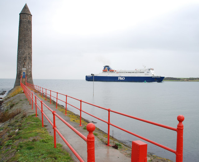
Larne is a major gateway to Northern Ireland courtesy of the ferry link to Cairnryan, 6 miles north of Stranraer in Scotland.  Formerly known as Latharna, from Lathar, son of the pre-Christian King Hugony the Great, one of the earliest records of the area dates from Roman times, when a galley bound for Scotland was blown off course to a place called Portus Saxa, believed to be Larne Lough.  The lough was later named after the Norse King Ulfrich during the time of the Viking raids.  Fast forward to the 18th century, when the quays which had been built in the port were used by people emigrating to America.  It was the coming of the railway which led to Larne being established as the departure point for ferries to Scotland, initially using a paddlesteamer called the Briton, a service which lasted until 1863.  Three years later the harbour was bought by James Chaine, a linen merchant’s son, who updated the port and re-established the link to Scotland.   People arriving at Larne by sea will be reminded of this by the Chaine Memorial Tower which dominates the harbour entrance. 


During the First World War Larne became a naval port, then during the Second World War the port played an important role for the Allied Forces, including as a conduit for troops preparing for the D-Day Landings.  In the post-war period, after various ups and downs with efforts to establish ferry links once more, the Larne-Cairnryan service finally started in 1973.  This outcome, which contributed considerably to the success of the port, was facilitated by one Colonel Frank Bustard, who was made a Freeman of Larne in recognition of his efforts.


If you are visiting Larne with a car or motorbike, the coastal route heading north from the town is highly recommended.  We did this route in the other direction after exploring the Antrim coast, and the journey was a delight due to the way the road hugged the coastline with the attendant views of Scotland.  At one point I nearly caused my husband to crash the car when I spotted a seal poking its head out of the water a short distance offshore. 


Back in town, the Larne Museum and Arts Centre provides a fascinating insight into the history of the town, including a display devoted to a famous warship called the Princess Victoria.  For lovers of the great outdoors, as well as the tower, James Chaine’s memory lives on in the form of Chaine Park, a green space with wonderful views, especially for people who, like me, love watching the comings and goings of shipping and ferries.  Just to the south of the port, the ruins of Olderfleet Castle, dating from at least the 13th century, lie on Curran Point facing the Lough.


For a list of events in Larne, follow this link.


File:The Chaine Memorial, Larne - geograph.org.uk - 620971.jpg
The Chaine Memorial, Larne - geograph.org.uk - 620971. Photo by Albert Bridge, via Wikimedia Commons.


Tuesday, 28 November 2017

CARRICKFERGUS


Many people like to dress up for marathons, as viewers of the annual London marathon will know – everything from a lion suit to a full antique diving suit.  What has this got to do with Carrickfergus I hear you cry?  Well, earlier this month a couple from Carrickfergus who are members of the local running club decided to work a marathon run into their wedding celebrations.  The couple, accompanied by their guests, changed into running gear with a wedding theme and ran a variety of distances so that as many people as possible could take part, right up to the full 26 miles.

Carrickfergus is on the north shore of Belfast Lough, just over the Antrim side of the County Down/County Antrim border which crosses the eastern suburbs of Belfast.  The town takes its name from Fergus the Great, a legendary king of Dál Riata, a kingdom that encompassed parts of Western Scotland as well as northeastern Ireland.  Carrickfergus was a prominent settlement before Belfast, meaning that until the 17th Century the Lough was known as Carrickfergus Bay.  John de Courcy, the Anglo-Norman knight who we have met several times already in this blog, established his headquarters here in the 12th century and built Carrickfergus Castle on "Carraig Fhearghais" (the rock of Fergus) in 1177.  

Carrickfergus has had an eventful history over the centuries, at one point even becoming involved in the American War of Independence.  During the Nine Years War, a struggle against English rule which began at the end of the 16th century, the town was the scene of the Battle of Carrickfergus, which saw the English defeated.  The much wider Seven Years’ War in the mid-18th century brought the forces of William of Orange to the town, where they besieged the castle for several days and William himself arrived on the scene.  In 1777 there was a naval duel off Carrickfergus between the British Royal Navy vessel HMS Drake and the 18-gun sloop Ranger of the Continental Navy, as the US Navy was called during the War of Independence, which the Americans won.  By the time of World War Two relations with the US had improved to the point where the US Rangers used the Sunnylands Camp in Carrickfergus for training before heading to Normandy.  The Andrew Jackson Cottage and US Rangers Centre includes a museum dedicated to the US Rangers.

Carrickfergus Castle is still remarkably well preserved and is open to visitors, with historical displays on view.  The castle occupies a fetching position on the northern shore of Belfast Lough.  Near the castle is the King William III (William of Orange) monument, a statue of the king commemorating his landing in the town.  Further away from the shore, the Carrickfergus Museum, attached to the Civic Centre, has displays dating from the Middle Ages onwards.  For visitors staying in Belfast, the town is easily reached by car or train from the capital.


File:Carrickfergus Castle (2) - geograph.org.uk - 733522.jpg
Carrickfergus Castle (2) - geograph.org.uk - 733522. Photo by Albert Bridge, via Wikimedia Commons.

Tuesday, 12 September 2017

CLOUGHEY AND KIRKISTOWN CASTLE


The village of Cloughey started out as a row of coastguard cottages at the south end of the beach.  It gained popularity as a holiday destination in the 1920s, helped no doubt by the presence of a golf course and a sandy beach fringing a gently curving bay.  However, not all of this stretch of coast is so benign.  The North and South Rocks in the sea off the village have long been considered one of the major hazards to shipping in the area.  In 1883 a ship called the Wild Deer carrying 300 emigrants heading for New Zealand foundered on the North Rocks in heavy seas.  Happily, the passengers were rescued with the help of the local fishing boats.  No doubt there would have been loss of life were it not for the fact that the passengers were implored to stay below deck, in fact the women were so panicked that the crew locked them in to prevent them from rushing up to the deck.

Kirkistown Castle is about a mile to the north of Cloughey, just outside the golf course bearing the same name.  It is believed to have been built in 1622 by Roland Savage, possibly on the site of an earlier construction.  The castle is typical of the area, with a three-storey tower house.  The tower house was threatened by subsidence, being built in a marshy area, necessitating the later addition of buttresses and iron braces.  There is also a motor racing circuit nearby, which was built on the site of an airfield established during the Second World War for the use of  the American Air Force. 


File:Cloughey Bay - geograph.org.uk - 837592.jpg
Cloughey Bay - geograph.org.uk - 837592. Photo by Albert Bridge, via Wikimedia Commons.

Monday, 13 March 2017

KILKEEL


This lively port is not only home to the largest fishing fleet in Northern Ireland, but is also the capital of the ancient Kingdom of Mourne, and as such is an ideal base for exploring the beautiful Mourne Mountains and Carlingford Lough.  Kilkeel has a long history dating back to megalithic times, with many dolmens (megalithic tombs) and raths (ancient circular dwellings) in the area.  The harbour, which was first started in the 1850s, is mainly dedicated to fishing for shellfish such as prawns and scallops, but there are proposals for an expansion including the construction of a new breakwater.     

In the past, Greencastle Pier at the mouth of Carlingford Lough was the scene of many a departure for the New World by local people searching for a new life.  During World War II there was a US aerodrome at Greencastle, which was the venue for a wartime commemorative festival called GI Jive last year – I have been unable to find out whether the festival is running again this year. 

One of Kilkeel’s most unpleasant residents over the years was William Hare, born Thomas O’Hare, one of the infamous body snatching duo known as Burke and Hare.  After testifying against Burke, which led to the latter’s hanging in 1829, Hare went to live out his days in Kilkeel, acquiring a wife and child with whom he lived in Newry Street.  He is said to be buried at the Burial Banks alongside the former Kilkeel Workhouse.


File:The weekend at Kilkeel harbour - geograph.org.uk - 583367.jpg
The weekend at Kilkeel harbour - geograph.org.uk - 583367. Photo by Albert Bridge, via Wikimedia Commons.

Monday, 29 August 2016

PERRANPORTH


The ‘Perran’ part of Perranporth derives from St Piran, the Patron Saint of Cornwall.  Legend has it that he was washed up on Perranporth beach, having been unceremoniously ejected from Ireland by an Irish King suspicious of his powers.  On his arrival he decided to set up an oratory where, the story goes, he found himself preaching Christianity to a congregation consisting of a badger, a fox and a bear.  The oratory was swallowed up by the sand from the surrounding dunes, but it was later excavated, then in 1981 it was buried again to preserve the structure.  The site is now marked by a memorial stone.  Another religious building to succumb to the dunes was the parish church dating from around 1150 and abandoned in 1804.  Only the ruined walls remain plus an ancient cross from the 10th century or earlier.  St Piran also lends his name to Piran Round, an Iron Age hill camp to the north-east of the village.  

Several centuries after St Piran’s arrival, tin and copper mining became the main activity in and around the village.  Perhaps this provided inspiration for Winston Graham, the author of the Poldark novels, who wrote the first one while living there.  Of course, the mining activity has ceased, but there are still reminders in the form of the remains of engine houses dotted around the landscape.  The Perranzabuloe Folk Museum tells the story of the mining industry as well as other aspects of local life (Perranzabuloe means ‘Perran in the sands’).  During the Second World War, there was a Spitfire Station at Perranporth Airfield.  The control tower has a memorial to the pilots who flew from here, who came from many different countries.  Today the airfield has been given over to more leisurely pursuits such as gliding.

Nowadays, Perranporth is a popular small resort where, as well as the sandy beach with caves and interesting rock formations, there is a golf course and a boating lake.  The big event of the year here is the Tunes In The Dunes festival, which takes place around late June/early July.  Penwartha Coombe is a tranquil oasis just outside the village, with a stream running through it.  A walk along the South West Coast Path heading west from Perranporth takes you past Droskyn Point, home to the Perranzabuloe Millennium Sundial.  The sundial tells Cornish time, which is 20 minutes ahead of GMT, so best not to set your watch by it.


File:Millennium sundial above Perranporth beach - geograph.org.uk - 1261455.jpg
Millennium sundial above Perranporth beach - geograph.org.uk - 1261455. Photo by Rod Allday, via Wikimedia Commons.