Labels

Aberdeenshire (21) Angus (4) antiquities (87) Argyll and Bute (35) Arran (7) art (37) birds (231) bridge (9) Caithness (12) Carmarthenshire (5) castle (165) Ceredigion (9) Channel Islands (13) Cheshire West and Cheshire (1) City and County of Swansea (1) City of Bristol (2) City of Edinburgh (4) Conwy (8) Cornwall (74) County Antrim (19) County Down (23) County Durham (3) County Londonderry (4) Cumbria (19) Denbighshire (2) Devon (48) diving (9) Dorset (18) Dumfries and Galloway (22) Dundee City (2) East Lothian (6) East Sussex (16) East Yorkshire (6) English Riviera (3) Essex (17) Fife (19) Flintshire (1) food (13) fossils (14) gardens (28) Ghosts (35) Glamorgan (1) Gower (7) Guernsey (4) Gwent (1) Gwynedd (19) Hampshire (13) Highland (72) Inner Hebrides (42) Inverclyde (5) Islay (8) Isle of Anglesey (14) Isle Of Man (7) Isle Of Wight (10) Isles of Scilly (3) Jersey (7) Kent (22) Lancashire (8) Lewis and Harris (7) lighthouse (62) Lincolnshire (8) Merseyside (8) Mid Glamorgan (1) mining (23) Moray (10) Mull (8) Norfolk (21) North Ayrshire (13) North Yorkshire (12) Northern Ireland (45) Northumberland (17) Orkney (10) Outer Hebrides (14) Pembrokeshire (27) pubs (47) Ross and Cromarty (20) Scotland (300) Scottish Borders (3) Shetland (14) shipwrecks (42) Skye (12) smuggling (48) Somerset (9) South Ayrshire (6) South Glamorgan (5) South Gloucestershire (1) Suffolk (18) surfing (84) Sutherland (16) Tyne and Wear (10) Wales (93) wartime (75) webcams (232) West Dunbartonshire (3) West Glamorgan (9) West Sussex (9)

Wednesday 28 February 2018

KINBANE CASTLE AND THE CARRICK-A-REDE ROPE BRIDGE


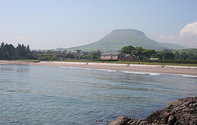
Heading north from Ballycastle on the way to Ballintoy we come to Kinbane Castle, reachable by a minor road off the Whitepark Road.  The castle is in ruins and there are many steps leading down to the main castle area, but those fit enough to tackle the approach will be rewarded with some of the best views on the Antrim coast.  The castle was built in 1547 by Colla MacDonnell, brother of Sorley Boy MacDonnell, and was laid siege to more than once by English forces.


As a member of the National Trust, I have visited many of their properties over the years, but possibly the most unusual site I have been to is the Carrick-a-Rede Rope Bridge.  The bridge was originally built in 1755 by fishermen to provide access to the small offshore island called Carrick, from where they were able to fish for salmon.  Now, under the auspices of the Trust the bridge is solely a novel tourist attraction, providing a frisson for visitors as they wobble their way across while daring themselves to look down at the foaming sea below.  The bridge is a popular attraction, so be prepared to wait to make the crossing, which is only 20 metres.  The island itself is very small, but offers wonderful coastal views and birdlife.  Back at the entrance to the site there is a cafe for visitors to warm up in.  The nearby village of Ballintoy has a number of facilities for visitors in the area, and the harbour is worth a visit for Game of Thrones fans, as it was used for the Iron Islands scenes.


File:Carrick a Rede.jpg
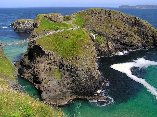
Carrick a Rede. Photo by Qole Pejorian, via Wikimedia Commons.


Friday 23 February 2018

BALLYCASTLE


This small resort is located in the far northeast of the Irish mainland and at the most northerly point of the Antrim coast.  Ballycastle’s main attraction is its wild and windswept beach, with lovely views along the coast to Fair Head.  At one end is an area known as Pans Rock, the remains of an iron salt pan used by fishermen, and just beyond that is the Devil’s Churn, with steps leading down to an underwater tunnel.  Ballycastle’s big event of the year is the Ould Lammas Fair, which originated in the 17th century, and which is the subject of a ballad by John Henry MacAuley, a sculptor by craft.  The first line of the ballad tells how “At the Ould Lammas Fair in Ballycastle long ago I met a pretty colleen who set me heart a-glow”.  The Fair is held on the last Monday and Tuesday of August.  The Ballycastle Museum has displays relating to the local area.


On the way in to Ballycastle by the road from Cushendall lie the ruins of Bonamargy Friary built by Rory MacQuillan in 1500.  88 years later the friary was seized by the rival MacDonnell clan.  Many of the features, including a cloister, altar and burial vault, are still relatively unscathed, although the roof is missing.  The friary is the last resting place of several Earls of Ulster and of Sorley Boy MacDonnell.  The friary is easily accessible from the road, free to enter, and there are information boards for visitors, who can also enjoy the lovely surroundings, including a golf course. 

Live streaming webcam view courtesy of Marine Hotel.

Map of the area.


File:Pans Rock - geograph.org.uk - 470238.jpg
Pan's Rock - geograph.org.uk - 470238.  Photo by Anne Burgess, via Wikimedia Commons.


Thursday 15 February 2018

TORR HEAD AND FAIR HEAD


Heading north out of Cushendun the Causeway Coastal Route takes on the name Torr Road, and after a few miles there is a turnoff from this to Torr Head.  This headland, with its spectacular views of the Mull of Kintyre, was used in the 1800s to record the passage of Transatlantic ships for Lloyds of London, and the remains of the old lookout station are still visible.  This was also one of the first places where Marconi’s wireless telegraphy system was installed.  Nestled against the headland on Portaleen Bay is a small harbour, a reminder of a former salmon fishery. 


Further north is Murlough Bay, known for its flora, fauna and geology, with birdlife including eider ducks and peregrine falcons.  Beyond the bay is Fair Head, which has been described as Northern Ireland’s tallest cliff face, rising to 600 feet above sea level.  As well as fantastic views along the coast and across to Scotland, there are goods views of Rathlin Island, which lies just across the way.  The headland is popular with rock climbers.  Running around the headland is a path called The Grey Man’s Path.  The Grey Man in question is said to derive from a local legend about a “devil-horse” living in nearby Lough Dhu who wandered along the path disguised as a human and frightened the living daylights out of a local woman called Mary McAnulty. 


File:Ballycastle beach, September 2010 (01).JPG
Ballycastle beach, September 2010 (01).  Photo by Ardfern, via Wikimedia Commons.


Friday 9 February 2018

CUSHENDUN


Like Cushendall, Cushendun, at the foot of Glendun, one of the nine Glens of Antrim, is classed as a “conservation village”, and as such is protected by the National Trust.  The name comes from the Irish Cois Abhann Duinne, which means “beside the River Dun”, the river that tumbles down from the valley of Glendun.  The village was planned in 1912 by Clough Williams-Ellis at the request of Baron Cushendun, and the Cornish appearance of the village is no accident, as Williams-Ellis designed it in this way to please the Baron’s wife Maud, who was from my home town of Penzance.  There is even a row of whitewashed cottages named after her. The village passed to the care of the National Trust in 1954.


Just to the north of the village is Castle Carra, thought to have been built in the 14th century and now a ruin.  The castle was the scene of a series of shenanigans involving Shane O’Neill and the McDonnells, culminating in O’Neill being stabbed to death as revenge for his earlier defeat of the McDonnells.  Not content with this act of violence, they cut his head off and sent it to representatives of Queen Elizabeth in Dublin. 


Last, and by no means least, fans of the hit series Game of Thrones will want to include a visit to Cushendun Caves on a visit to the village.  The caves, formed from over 400 million years of weathering, appeared in the series as the background for the Stormlands, one of the nine constituent regions of the Seven Kingdoms.  They can be reached by following the walk suggested via this link.  


File:Cushendun Caves - geograph.org.uk - 467791.jpg
Cushendun Caves - geograph.org.uk - 467791. Photo by Anne Burgess, via Wikimedia Commons.

Thursday 1 February 2018

CUSHENDALL


Formerly known as Newtown Glens, Cushendall and the surrounding area is classed as a “conservation area”.  The ‘dall’ part of the name comes from the River Dall which tumbles down to the beach via the Cushendall Golf Club course.  One of the main historic landmarks in the village is the Curfew Tower, also known as Turnly’s Tower, after Francis Turnly of the East India Company, who erected the tower as “a place of confinement for idlers and rioters”.  However, the history of the area goes back much further; there are the remains of Bronze Age forts in the mountains overlooking the village.  In 1924 the village became one of the first places in Ireland to have street lighting installed. 


On the outskirts of the village is Cottage Wood, with footpaths, viewpoints and picnic facilities.  Lovers of wildlife should keep their eyes peeled for the Red Squirrel, which are regularly seen here.  About a mile outside the village lie the evocative ruins of the Layd Old Church, dating from the early 1600s, although records suggest a church existed here as long ago as 1288.  Cushendall’s big event of the year is the Heart of the Glens Festival, which takes place in August and is a throwback to the days when there were eight fair days held throughout the year.


File:Cushendall Beach - geograph.org.uk - 467693.jpg
Cushendall Beach - geograph.org.uk - 467693. Photo by Anne Burgess, via Wikimedia Commons.