Labels

Aberdeenshire (21) Angus (4) antiquities (87) Argyll and Bute (35) Arran (7) art (37) birds (231) bridge (9) Caithness (12) Carmarthenshire (5) castle (165) Ceredigion (9) Channel Islands (13) Cheshire West and Cheshire (1) City and County of Swansea (1) City of Bristol (2) City of Edinburgh (4) Conwy (8) Cornwall (74) County Antrim (19) County Down (23) County Durham (3) County Londonderry (4) Cumbria (19) Denbighshire (2) Devon (48) diving (7) Dorset (18) Dumfries and Galloway (22) Dundee City (2) East Lothian (6) East Sussex (16) East Yorkshire (6) English Riviera (3) Essex (17) Fife (19) Flintshire (1) food (13) fossils (14) gardens (28) Ghosts (35) Glamorgan (1) Gower (7) Guernsey (4) Gwent (1) Gwynedd (19) Hampshire (13) Highland (72) Inner Hebrides (42) Inverclyde (5) Islay (8) Isle of Anglesey (14) Isle Of Man (7) Isle Of Wight (10) Isles of Scilly (3) Jersey (7) Kent (22) Lancashire (8) Lewis and Harris (7) lighthouse (62) Lincolnshire (8) Merseyside (8) Mid Glamorgan (1) mining (23) Moray (10) Mull (8) Norfolk (21) North Ayrshire (13) North Yorkshire (12) Northern Ireland (45) Northumberland (17) Orkney (10) Outer Hebrides (14) Pembrokeshire (27) pubs (47) Ross and Cromarty (20) Scotland (300) Scottish Borders (3) Shetland (14) shipwrecks (42) Skye (12) smuggling (48) Somerset (9) South Ayrshire (6) South Glamorgan (5) South Gloucestershire (1) Suffolk (18) surfing (83) Sutherland (16) Tyne and Wear (10) Wales (93) wartime (75) webcams (232) West Dunbartonshire (3) West Glamorgan (9) West Sussex (9)

Sunday 30 June 2013

THE MULL OF GALLOWAY AND DRUMMORE


The Mull of Galloway is not only the most southerly point of the Rhinns Of Galloway, it is also the most southerly place in Scotland.  Visitors can enjoy extensive views of the Solway Firth and even the Isle Of Man.  When I was in Peel recently on a visit to the Isle Of Man I could make out what I was pretty sure was the southern end of the Rhinns Of Galloway.  As befits such a geographical distinction, it 
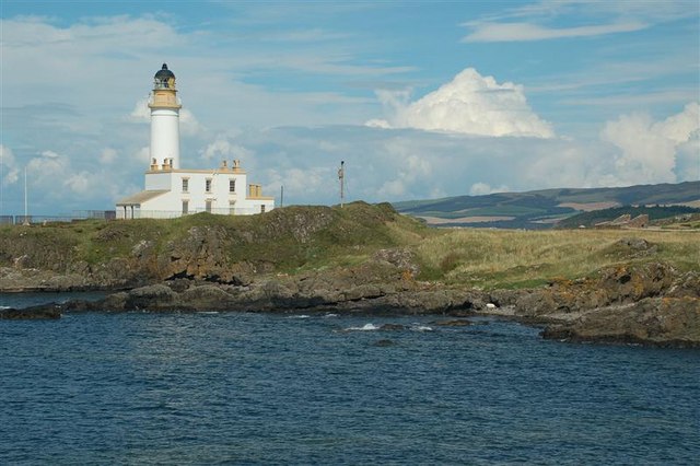
has a suitably handsome, whitewashed lighthouse, known as Stevenson Tower, since it was built by the prolific builder of lighthouses, Robert Stevenson.  The lighthouse, which is 26 metres high, came into operation in 1830.  It is open to visitors, who can visit an exhibition in the Engine Room and, when open, can access the tower.  Aside from lighthouse enthusiasts, the Mull Of Galloway is a magnet for birdwatchers, being an RSPB site.  Gullemots, kittiwakes, peregrine falcons, puffins and gannets are the species to watch out for, and in summer they are joined by basking butterflies. 

While the Mull Of Galloway is the most southerly point in Scotland, the village of Drummore is the most southerly Scottish village.  The harbour started out in the 1800s as a point of departure for the locally produced lime, and for imported coal, but it later turned to defence use when the Ministry of Defence took it over with the establishment of West Freugh and Luce Bay bombing ranges.  RAF West Freugh was an armament training camp just before World War II but after war broke out the training activities were expanded, including the use of a bombing range.  The MOD have since moved out, leaving the harbour to more pleasurable pursuits.  Drummore is a popular small resort, thanks in part to the nice sandy beach in Drummore Bay.  Out at sea there are a number of small rocky islands called The Scars which are managed by the RSPB and host colonies of gannets during the breeding season.  

Map of the area. 

File:Mull of Galloway lighthouse - geograph.org.uk - 592045.jpg

Mull of Galloway lighthouse - geograph.org.uk - 592045. Photo by Derek Ball, via Wikimedia Commons

Thursday 27 June 2013

PORT LOGAN


Port Logan (formerly Port Nessock) has experienced the same problems as Portpatrick (see previous post) in its attempts to provide protection from the rough seas along this stretch of coast.  In the early 19th century one Colonel Andrew McDouall, the laird of Logan, had the idea of building a harbour development in order to profit from the Irish cattle trade but the sea put paid to his ambitions.  However, the village does have a pier with a charming stone lighthouse at the end.  The village of Port Logan, with its whitewashed cottages, was the setting for the BBC series Two Thousand Acres Of Sky, which screened in the early Noughties.  The village played the role of the fictional island of Ronansay off the coast of Skye.  In 1944 a wartime tragedy occurred at Port Logan when a Douglas C-47 belonging to the USAAF, en route to the USA and carrying wounded soldiers, crashed into the cliffs at Port Logan killing all 22 passengers and crew.

There is a sandy beach to the north of the village which is reached by wooden stairways, and from a here a short walk leads to Logan Fish Pond, created in 1800 to provide fish for the nearby Logan House.  The fish were so tame that they answered a bell to be fed.  Nowadays the pond is still home to around 30 fish, mainly cod, and they are still as tame as ever, so much so that they can be hand fed by visitors.  Logan House has some fine gardens known as Logan House Gardens, but they are a private estate, unlike the nearby Logan Botanic Garden, which is open to visitors.  The latter has a variety of fascinating areas crammed with exotic plants, some rarely found in Britain.  There is the Woodland Garden, the Walled Garden and the Terrace Garden with its avenue of Chusan Palms.  In addition there are the rhododendron collections and over 50 species of eucalyptus. 

Map of the area. 

File:Port Logan.jpg

Port Logan. Photo by Patrick Lee, via Wikimedia Commons

Tuesday 25 June 2013

PORTPATRICK


Most of you will have heard of Gretna Green, the town by the Scotland/England border where lovers have traditionally eloped to get married in secret.  What is less well known is that Portpatrick once served a similar purpose for Irish lovers.  Until 1826 the Church of Scotland took advantage of Portpatrick's position on the Rhinns of Galloway, the closest point on the Scottish coast to Ireland, by running a profitable line in quick and easy weddings with no questions asked.  The crossing from Ulster was just 21 miles, and eloping couples could be married within a couple of days of disembarking in Scotland.  Aside from blushing brides and their grooms, this crossing was used to send mail to Ireland and to bring cattle back the other way.  However, Portpatrick's time as a ferry port was to prove short-lived due to the ferocity of the sea off this coast.  Over the years the efforts of John Smeaton (he of Smeaton's Tower in Plymouth), John Rennie and Thomas Telford proved unequal to the task of protecting the port through their respective harbour and lighthouse constructions, so that the packet boats were forced to move to Stranraer, which had the advantage of a much calmer disposition being located on the shores of Loch Ryan.

That is not to say that Portpatrick became a backwater with the departure of the packet boats.  It has developed into a much loved and attractive small resort offering sailing and other water-borne leisure activities.  There is a small sandy beach backed by cliffs with a clifftop golf course.  The ruined 17th-century Old Church, or St Andrew's Kirk has a distinctive Irish-style round tower; the graveyard here is a reminder of the savagery of the seas off this coast judging by the number of graves housing victims of shipwrecks hereabouts.  Portpatrick is one end of a long-distance path, the 212-mile Southern Upland Way (the other end being at Cockburnspath on the North Sea).  For a shorter walk, head along the clifftop path towards the south, which offers fine sea views and which leads to the ruined 16th century Dunskey Castle.


Map of the area.  

File:Portpatrick Harbour - geograph.org.uk - 1012939.jpg

Portpatrick Harbour - geograph.org.uk - 1012939. Photo by Arnold Price, via Wikimedia Commons

Sunday 23 June 2013

KIRKCOLM


The name Kirkcolm applies to both a village and its surrounding area, in the north of the Rhinns Of Galloway.  The name probably derives from the local church (kirk) which has St Columba's Well in its churchyard, although it was once known by the more English-sounding name of Stewarton.  Nearby Wig Bay has a sandbank called The Scar which is home to a large colony of nesting migrant terns in the summer, as well as attracting eider ducks and oystercatchers.  During the war the bay was home to RAF Wig Bay, and a slipway can be seen which is a reminder of the fact that flying boats and seaplanes operated from here during both world wars.  A minor road heading north-east from the village of Kirkcolm leads to Corsewall Point with its lighthouse, one of many built by Robert Stevenson.  The views from the Point are spectacular, taking in Ailsa Craig and Ireland, which is relatively close to this part of the coast.  If, like me, you enjoy large ships going backwards and forwards, it is also a great vantage point for watching the ferries departing from and arriving at nearby Cairnryan.   To the north of Kirkcolm is Clachan Heughs where the woodland contains trees which were laid out in the exact formation of Sir John Moore's troops at the Battle of Corunna in 1809.  The polar explorer Sir John Ross (see the Stranraer post) was born in Kirkcolm. 

Map of the area. 

File:Corsewall Lighthouse from Cairnside Farm - geograph.org.uk - 293900.jpg

   Corsewall Lighthouse from Cairnside Farm - geograph.org.uk - 293900. Photo by alice shirley, via Wikimedia Commons.

Friday 21 June 2013

STRANRAER


Stranraer's fortunes as a port have followed a somewhat different trajectory from those of nearby Cairnryan (see previous post).  Whereas Cairnryan started out from next to nothing and grew into an important military, then civilian port, Stranraer has gone in the opposite direction.  The harbour was built in the mid-18th century, but it was not until the arrival of the railway in 1861 that the town became the area's main port.  In 1872 the town became the main terminal for steam packets to Northern Ireland, and these services continued until recently with Stena and P & O both operating services from there.  However, they have both since moved to new facilities in Cairnryan.  This has left the town with the dilemma of what to do with its waterfront, which is why a regeneration of the waterfront area is now underway. 

The origins of the town date back to 1511, with the building of the Castle of St John, a medieval tower house which was flanked by a medieval chapel, since demolished.  In the late 17th century it was the headquarters of John Graham of Claverhouse, 1st Viscount Dundee (aka Bluidy Claverhouse), a much feared persecutor of Covenanters.  The castle later came to be used as a prison, a courtroom and a police station, and this period of its use is remembered in some of the exhibits on show to visitors.  There is a handsome building on the waterfront which was built in 1820 for the Arctic explorer and naval officer Sir John Ross, the son of a minister in the local Inch parish.  The building is now the North West Castle hotel, which has its own indoor curling rink.  The Old Town Hall was built in 1776 and now houses the Stranraer Museum, which includes displays on Sir John Ross and his nephew James Clark Ross, also a polar explorer.  As well as the attractions of the town itself, Stranraer is the gateway to the Rhins of Galloway, the distinctive hammer-head shaped piece of land, which includes the Mull of Galloway, Scotland's most southerly point. 

Map of the area. 

File:"Millennium Centre", George Street, Stranraer - geograph.org.uk - 164305.jpg

"Millennium Centre", George Street, Stranraer - geograph.org.uk - 164305. Photo by Oliver Dixon, via Wikimedia Commons

Wednesday 19 June 2013

CAIRNRYAN


A glance at the map to the south of Ballantrae reveals a very striking geographical feature: an elongated chunk of land called the Rinns of Galloway, which has the appearance of a hammer head.  The wider part to the north wraps itself around Loch Ryan, a stretch of water which has seen plenty of wartime and peacetime activity over the years.  The settlement of Cairnyran on the east shore of the loch was established in the early 18th century with the construction of Lochryan House, along with housing for the workers from the Lochryan Estate.  The village was transformed into a major port by the onset of World War II when the Army built three piers and a military railway link to Stranraer and the resulting facility became the No. 2 Military Port.  Among the most significant activities to take place here was the building of the floating Mulberry harbours used in the D-Day landings.  At the end of the war the Atlantic U-Boat fleet surrendered in Loch Ryan and was anchored in Cairnryan before being scuttled (deliberately sunk) in the North Channel as part of Operation Deadlight.  There was further periodic military activity after the war until most of the infrastructure was dismantled in the early 1960s.  The village then became a centre for ship breaking; the ships sent for demolition included such luminaries as the Ark Royal.  By 1990 Soviet Navy submarines were being dismantled for scrap in Cairnryan.  Nowadays, Cairnryan is still an important port, but with more leisurely voyages in mind.  A large, modern ferry port has been built there with the purpose of providing links to Northern Ireland: Stena Line operates a service to Belfast, while P & O Irish Sea takes care of the Cairnryan to Larne route.

Map of the area. 

File:Passing to the west of Cairnryan Pier en route to Larne - geograph.org.uk - 1322251.jpg

Passing to the west of Cairnryan Pier en route to Larne - geograph.org.uk - 1322251. Photo by Des Colhoun, via Wikimedia Commons

Monday 17 June 2013

BALLANTRAE


People who, like me, enjoy looking at old photographs may want to check out the Ballantrae website, which has a nice collection of old images of the village, some looking out to sea, with the ever-present Ailsa Craig on the horizon, others showing street scenes with the residents in their fashion of the day.  The website also has a fascinating timeline of events, happy and sad, which have taken place there over the years, starting from 1806.  Another interesting feature of the website is a table showing a comparison between the 1900 village and the present one.  As a sad sign of the times, it reveals that in 1900 there were 6 grocers, but only one now; there was a baker in 1900, now there are none; and in 1900 there was a post office, while the present-day post office is inside the grocers.  The shingle beach at Ballantrae is a nature reserve, classed as a Site of Special Scientific Interest, with nesting grounds in the nearby cliffs.  The beach lies between the harbour at the north end and the mouth of the River Stinchar at the south end, which is dominated by the ruins of Ardstinchar Castle, once home to the Kennedys of Bargany, where Mary Queen of Scots spent a night in August 1566.  The village was immortalised in literature in a book by Robert Louis Stevenson called The Master of Ballantrae, about a family feud during the Jacobite Uprising.  Ballantrae has its own Gala Week, which this year starts on 29th June, preceded by the crowning of the Gala Queen and Gala King on 14th June.

Map of the area. 

File:Ardstinchar Castle and bridge Ballantrae Scotland.jpg

Ardstinchar Castle and bridge, Ballantrae, Scotland LOC 3450358748. The Library of Congress, via Wikimedia Commons

Friday 14 June 2013

GIRVAN AND AILSA CRAIG

Girvan was granted burgh status in 1668, and its economy developed from shoemaking, weaving and fishing.  The town became a popular resort with the arrival of the railway in 1860, bringing daytrippers from Glasgow.  There is still an active fishing fleet operating from the harbour, which lies at the mouth of the river named the Water Of Girvan.  Girvan's beaches offer views to Arran to the north, and to Ailsa Craig out at sea, including a nice view from the local golf course.  The town centre is dominated by the spire of North Parish Church, which was built in 1883.  Another prominent tower is Auld Stumpy, the last surviving part of McMaster Hall, which burned down in 1939.  The McKechnie Institute in the centre of town is an art gallery and museum with changing exhibitions.  Each year in early summer the Carrick Lowland Gathering takes place in Girvan, with traditional Scottish entertainment such as pipe bands and a highland dancing competition.  Another major event in June is the Gig On The Green, with a variety of bands and other entertainment.

Looking out to the horizon west of Girvan, the eye is drawn to a distinctive small island rising up out of the sea.  This is Ailsa Craig, which is visible from miles around - I remember seeing it when visiting the Mull Of Kintyre a few years ago.  The name of the island, which is 10 miles offshore from Girvan, comes from the Gaelic for "Fairy Rock".  It was part of an ancient volcano, and features the typical columnar rock formations seen in a number of places in this part of the world - Fingal's Cave and The Giant's Causeway being two more examples.  The rock is a source of a particularly prized form of granite which is used to make curling stones.  In the 19th century there were around 29 inhabitants, working in the quarries and the lighthouse, built in 1883-1886 by Thomas and David Stevenson, but as the quarries closed and the lighthouse went automatic the island became depopulated save for its huge seabird colonies.  The island is home to one of the world's largest gannet colonies with over 70,000 birds, and it has been designated a European Special Protection Area.  Ailsa Craig can be reached by boat from Girvan.

Map of the area.  


File:By The North Breakwater - geograph.org.uk - 1068562.jpg

By The North Breakwater - geograph.org.uk - 1068562. Photo by Mary and Angus Hogg, via Wikimedia Commons

Wednesday 12 June 2013

MAIDENS AND TURNBERRY


Maidens originated as a fishing village, and it has a number of old buildings with interesting connections.  Robert Burns used to drink in The Cellars, among the oldest buildings in the village but which has since been modernised.  Meanwhile, just outside the village is Shanter Farm, where one of Burns' most famous characters, Tam O'Shanter, lived.  There is another old cottage with the intriguing name "Weary Nuek".  Robert The Bruce allegedly landed here from Rathlin Island in 1307, sat down on a stone at the site of the cottage and declared that "this is a weary, weary nuek".

Looking at the map of Turnberry, one prominent feature stands out: a stonking great golf course.  This is the Ailsa, one of the courses afforded the honour of hosting the Open Championship.  The course is named after a distinctive island out to sea called Ailsa Craig which can be seen on the horizon, a sight which is particularly memorable when backed by a magnificent sunset.  Another notable feature in the view from the golf course is the Turnberry lighthouse, 24 metres high and built in 1873 to a design by David and Thomas Stevenson.  The Ailsa, along with another course called The Kintyre, form part of the luxurious Trump Turnberry Resort.  The resort opened in 1906, with the hotel at its heart then named the Station Hotel.  During World War I the resort was used as an airbase, and the disused landing strip is still visible.  The Royal Flying Corps used the site for training purposes, and the hotel itself was used as a hospital for the wounded.  This scenario was repeated during World War II, this time with the Royal Air Force doing the training.  There is a memorial to lost airmen on a hill overlooking the 12th green.


File:Turnberry Lighthouse - geograph.org.uk - 907831.jpg

Turnberry Lighthouse - geograph.org.uk - 907831. Photo by Mary and Angus Hogg, via Wikimedia Commons


Monday 10 June 2013

CULZEAN CASTLE


Culzean Castle, designed by Robert Adam, was built as a "bachelor pad" for David Kennedy, 10th Earl of Cassillis.  Construction took place over a number of years between 1777 and 1792.  However, the site was previously inhabited during medieval times, when a network of fortified caves were established below the present castle's clifftop location.  During the 18th century the Firth of Clyde was a notorious centre of smuggling.  Alcohol, tobacco and silks were brought over from Ireland and the Isle Of Man and the caves proved an ideal place for hiding the contraband from the Revenue.  We cannot be sure whether the Kennedy family knew what was going on under their noses, but it seems likely that they did know, and that they were willing to turn a blind eye in return for a share of the profits.  In 1945 General Dwight D. Eisenhower was gifted a suite of rooms at the top of the castle in a show of gratitute for his services during the Second World War.  Eisenhower gratefully accepted, and visited the castle several times, including once after he became President of the USA.  These apartments are now available for rent from the National Trust of Scotland.   Culzean Castle has an intriguing collection of ghosts and paranormal phenomena, and once featured in the Most Haunted TV series.  Spooky occurrences at the castle have included: the sound of bagpipes at a tree-lined walk called Piper's Brae, but no sign of anyone playing them; a misty shape moving up the oval staircase; the ghost of a woman in a ballgown; and the White Lady, thought to be the ghost of an ill-treated maid.

Map of the area. 

File:Culzean and Mochrum Hill - geograph.org.uk - 231308.jpg

Culzean and Mochrum Hill geograph.org.uk - 231308. 
. Photo by Mary and Angus Hogg, via Wikimedia Commons

Thursday 6 June 2013

PRESTWICK AND AYR


Prestwick, which is the oldest burgh in Scotland, having been granted the honour in 987, is just to the north of Ayr, and more or less runs straight into its larger neighbour.  Prestwick was the original home of golf's Open Championship, which was played out on its12-hole course in the years from 1860 to 1872.  The first tournament was over in a day, involving just eight golfers, all of them professionals, each playing three rounds.  St Ninian's church on the south side of town includes a well called Bruce's Well, the reason for the name being that Robert The Bruce was supposedly cured of leprosy by the waters from the well.

Ayr is one of the most popular resorts on this stretch of coast.  Its charms were not lost on Robert Burns, who in Tam O'Shanter written in 1791 described the town as "Auld Ayr, wham ne'er a toun surpasses, For honest men and bonnie lasses".  Earlier, in the 13th century, William Wallace was too busy engaging in increasingly violent encounters with the English soldiers garrisoned there to notice the area's delights.  During medieval times, Ayr was the most prominent harbour town on the west coast of Scotland.  By the 18th century the harbour was facilitating trade across the Atlantic, and in the 19th century it became a major industrial port.  It was also in the 19th century that Ayr blossomed into a smart resort with attractive parks and golf courses.  The town is an essential stopover for Robert Burns fans.  Burns was born in the southern outskirts of the town, and his birthplace is now a museum.  He was baptised in the 17th century Auld Kirk.  The Tam O'Shanter pub, which was frequented by Burns, was formerly a museum.  As if these were not enough reminders of the town's associations with the poet, there is a Burns Monument, designed in 1820 by Thomas Hamilton.  Other leisure activities in the town include sea-fishing trips from the harbour and the town is visited by the Waverley Paddle Steamer.  There is a lovely beach in the south of Ayr Bay dominated by the Heads of Ayr cliffs.  This area also houses the ruins of the 16th century Greenan Castle, built by John Kennedy of Baltersan and occupying a perilous clifftop location.  There is also a popular farm park in the vicinity.  

For a list of events in Ayr and the surrounding area see here

Map of the area.

File:Ayr from Brown Carrick Hill - geograph.org.uk - 372659.jpg

Ayr from Brown Carrick Hill - geograph.org.uk - 372659. Photo by Mary and Angus Hogg, via Wikimedia Commons

Tuesday 4 June 2013

TROON


It could be said that Troon is the west coast of Scotland's answer to St Andrews.  The town has six golf courses, one of which, the Royal Troon Golf Club, is one of a handful of courses afforded the honour of hosting the Open Championships.  The next time the Troon Royal is due to hold the Open is in 2016, but at the end of this month the Byrne Howard Junior Open is due to take place.  As well as golf, Troon is a popular resort for waterborne activities, in particular sailing and kitesurfing.  Pleasant walking can be had on a footpath which runs behind the curving sands of South Beach.  Early in the 19th century the first railway in Scotland brought coal from inland to the harbour at Troon.  The harbour used to be the focus of much of the local economic activity, from shipbuilding at the Ailsa Shipbuilding Company to fishing, after the fishing fleet at Ayr moved to Troon.  Nowadays, however, the harbour is given over to leisure craft.

The Live@Troon music festival takes place in early September.  For other events, follow this link.

Live streaming webcam views from Troon Yacht Haven.

Map of the area. 

File:Troon Yacht haven - geograph.org.uk - 50700.jpg

Troon Yacht haven - geograph.org.uk - 50700. Photo by Gordon Brown, via Wikimedia Commons

Saturday 1 June 2013

IRVINE


A recent newspaper report has suggested that Irvine is one of Scotland's cheapest coastal towns to live in, with average house prices running at less than £100,000, less than a third of the average price in Scotland's priciest coastal town, North Berwick on the east coast.  So what does the town offer would-be residents?  The main attraction nowadays is the regenerated harbourside, which boasts the Scottish Maritime Museum as well as an attractive mix of old and new cottages and houses, leisure craft in the harbour and several harbourside pubs, plus two golf courses, all of which makes for a good enough reason to visit the town, or even take advantage of the house prices and move there.  On the northern edge of town is Eglinton Country Park, which includes the remains of Eglinton Castle, built in the late 18th century.  There are a number of grandiose buildings in the town, such as the Irvine Town House, which point to more prosperous times in the past.  Coal mining and coal exports were a particular mainstay of the local economy until the coal industry was brought to its knees.  Partly because of this, Irvine was designated a New Town and acquired a Development Corporation in 1966.  However, this did not prevent the town reaching a low point in the 1980s, when unemployment was running at 22% as a result of industrial decline.  However, the harbourside regeneration plus the arrival of new sources of employment have gone some way to reverse this trend.

Irvine's origins date back to the 12th century, when the settlement was given burgh status by Hugh de Morville, Great Constable of Scotland, and was Scotland's Military Capital.  Irvine subsequently acquired a reputation as a centre of learning and as such was praised by James Boswell and Daniel Defoe.  Edgar Allan Poe went to school in Irvine's kirkgate.  As well as such cerebral pursuits, the town can be credited with a number of inventions, such as the Pneumatic Tyre.  Two of the town's streets, Burns Street and Burns Crescent, are a reminder that Robert Burns once worked in a flax mill there.  The mill was located on the Glasgow Vennel, a conservation area, and there is a museum in the town devoted to Burns.   

Map of the area.  

http://upload.wikimedia.org/wikipedia/commons/7/7a/Irvineharbourbuildings.JPG
Irvineharbourbuildings. Photo by Rosser1954, via Wikimedia Commons