Labels

Aberdeenshire (21) Angus (4) antiquities (87) Argyll and Bute (35) Arran (7) art (37) birds (231) bridge (9) Caithness (12) Carmarthenshire (5) castle (164) Ceredigion (9) Channel Islands (13) Cheshire West and Cheshire (1) City and County of Swansea (1) City of Bristol (2) City of Edinburgh (4) Conwy (8) Cornwall (74) County Antrim (19) County Down (23) County Durham (3) County Londonderry (4) Cumbria (19) Denbighshire (2) Devon (48) diving (9) Dorset (18) Dumfries and Galloway (22) Dundee City (1) East Lothian (6) East Sussex (16) East Yorkshire (6) English Riviera (3) Essex (17) Fife (19) Flintshire (1) food (12) fossils (14) gardens (28) Ghosts (36) Glamorgan (1) Gower (7) Guernsey (4) Gwent (1) Gwynedd (19) Hampshire (13) Highland (72) Inner Hebrides (42) Inverclyde (5) Islay (8) Isle of Anglesey (14) Isle Of Man (7) Isle Of Wight (10) Isles of Scilly (3) Jersey (7) Kent (22) Lancashire (8) Lewis and Harris (7) lighthouse (62) Lincolnshire (8) Merseyside (8) Mid Glamorgan (1) mining (23) Moray (10) Mull (8) Norfolk (21) North Ayrshire (13) North Yorkshire (12) Northern Ireland (45) Northumberland (17) Orkney (10) Outer Hebrides (14) Pembrokeshire (27) pubs (50) Ross and Cromarty (20) Scotland (299) Scottish Borders (3) Shetland (14) shipwrecks (42) Skye (12) smuggling (48) Somerset (9) South Ayrshire (6) South Glamorgan (5) South Gloucestershire (2) Suffolk (18) surfing (92) Sutherland (16) Tyne and Wear (8) Wales (93) wartime (75) webcams (232) West Dunbartonshire (3) West Glamorgan (9) West Sussex (9)
Showing posts with label mining. Show all posts

Wednesday, 7 December 2016

CAPE CORNWALL AND ST JUST


Cape Cornwall is the second most prominent headland on the West Cornwall coast after Land’s End.  In my very first post at the start of this blog, I cautioned that Land’s End is not the cheap option it once was, due to the ‘Disneyfication’ of the site with a range of shops and attractions.  Some people like that sort of thing, but for those who do not, I strongly recommend a visit to Cape Cornwall, where you will get the same “end of the world” feeling without the fanfare.  There is a National Trust car park (free to members), and a refreshment van, and that is about it, apart from the Cape Cornwall Club just above the headland, which offers golf and accommodation.  For those who want to stretch their legs there is a path around the headland, and wonderful views of Land’s End and the Longships lighthouse.  The Cape is crowned by the chimney which is all that remains of the Cape Cornwall Mine, a tin mine which operated between 1838 and 1883.   Another option for walkers is the path descending from the car park to Priest’s Cove, from where the South West Coast Path heads southwards, passing Ballowall Barrow, a Bronze Age burial chamber (English Heritage, free entry).

Cape Cornwall is reached by a minor road from the vibrant small town of St Just, England’s most westerly town.  The town was a thriving hive of activity during Victorian times thanks to the area’s tin-mining activities.  Up to the 17th century medieval miracle plays were performed in Plain-an-Gwarry, the natural grassy amphitheatre in the centre of St Just, and this continues to be used today for more modern festivities such as the annual Lafrowda Festival in July, a colourful music and arts festival.  St Just is also home to the original Warren’s Bakery, founded in 1860, which now has branches all over the county, and which makes some of the best pasties around.

Live streaming webcam view of the Cape Cornwall Club golf course.

Map of the area. 

File:Cape Cornwall (Judithili).jpg
Cape Cornwall (Judithili). Photo by Judithili, via Wikimedia Commons.

Saturday, 26 November 2016

BOTALLACK AND KENIDJACK


Continuing the mining theme, just along the road from Pendeen are the neighbouring villages of Botallack and Kenidjack.  The mining landscape between the villages and the coast path is some of the best in Cornwall, and includes the remains the engine house Wheal Edward, part of the Wheal Owles Mine Sett.  In 1893 Wheal Owles was the scene of a tragic accident, when water came rushing in from a flooded neighbouring mine, a common hazard in the Cornish mines, which often extended far out under the sea.  20 men were drowned in the accident, almost half the men who were down the mine at the time.  The Botallack Count House Workshop, owned by the National Trust but free to enter, has information on mining in the area and on Poldark, as well as a cafe, all housed in a building which performed an essential role as the place where the miners went to collect their pay.  The nearby Crowns Engine Houses in Botallack occupy a dramatic position towards the lower end of the cliff, and featured in the latest Poldark series.  Kenidjack Headland is home to an Iron Age cliff castle, and there are Bronze Age cairns in the area.  The views of Cape Cornwall from here and, on a clear day the Scilly Islands, are spectacular.  If all this is not enough to tempt walkers out onto the headland, birding enthusiasts will have the added pleasure of keeping an eye out for peregrine falcons and Cornish choughs, identifiable by their red bills.

Map of the area.

File:Botallack Crowns engine houses.jpg
Botallack Crowns Engine Houses. Photo by Nilfanion, via Wikimedia Commons.

Thursday, 17 November 2016

PENDEEN


The village of Pendeen is strung out along the B3306, with Carn Eanes, known locally as “The Carn”, towering over it.  The moorlands above the village are dotted with prehistoric sites and relics of the local mining industry.  The village is separated from the coastal path by fields with assorted farm animals.  Over in the distance the handsome whitewash lighthouse known as Pendeen Watch, built in 1891, still lights up as soon as dusk descends, warning passing ships off this treacherous stretch of coast.  The coastal path heading east from the lighthouse leads to the delightfully secluded Portheras Cove.  Pendeen was otherwise known as Boskaswal Wartha, and the present-day village is divided into Higher Boscaswell and Lower Boscaswell.  Anyone wanting to get a sense of the landscape around here should read ‘A Perfectly Good Man’ by Patrick Gale.  My mother and stepfather live in the village, and reading this book the description of the main character’s house and surroundings felt eerily familiar.

                                                         View towards Pendeen Watch


Between Pendeen and the neighbouring village of Trewellard is the entrance to Geevor Tin Mine, which offers tours of the old mine workings.  The mine was operational for a good part of the 20th century, and owes its existence to a group of St Just miners who had emigrated to South Africa but were forced to return due to the outbreak of the Second Boer War.  Being claustrophobic, I have not been on the mine tour, in spite of its proximity to my relatives’ house.  However, I can vouch for the novel experience of walking through this evocative industrial landscape.  It is a steep and uneven walk down to the coastal path below, but well worth it for the chance to perch on the cliff top and gaze down at the sea crashing against the rocks.  Near Geevor Mine is the Levant Mine and Beam Engine, owned by the National Trust.  Poldark fans may recognise it, as it doubled up as Tressiders Rolling Mill in the TV series.

Displaying IMG_20150815_135044.jpg
Relics of the mining industry at Geevor


Pendeen Lighthouse, by Barbara Ashley


Map of the area.


Friday, 11 November 2016

GURNARD'S HEAD


This prominent headland on the stretch of coast between St Ives and Lands End got its name from the fact that its shape is reminiscent of the gurnard fish.  There has always been a lone pub on the headland as long as I can remember.  Back in the day it was a normal, unassuming St Austell Ales inn, but now, as a sign of the times, it has been turned into a smart hotel and gastropub, no doubt a welcome stop along this wild coast for those walking the South West Coast Path. 

There is an iron age hill fort called Trereen Dinas (‘fort at the farm on the point’) on the headland, the remnants of which can still just about be made out in the form of a ditch and a bank with some drystone walling.  In the early 1800s there was a copper mine named Wheal Treen in operation on Gurnard’s Head, but it fell into disuse in 1877.  Now there is just the hotel and the nearby village of Treen.  The nearest beach to the headland is Treen Cove, a short distance to the east of the headland.  Probably not one for families, as there are no facilities and no lifeguard cover, just the wild beauty of the Atlantic breakers crashing on to the shore.

Map of the area. 

Gurnard's Head, by Barbara Ashley

Sunday, 11 September 2016

PORTHTOWAN AND PORTREATH


The area around the small seaside village of Porthtowan used to be alive with the sound of mining, dominated by the Wheal Towan copper mine.  The mine is said to have brought its owner Ralph Allen Daniell of Trelissick the equivalent today of £10,000 a week, making him the JR Ewing of Cornwall.  The old tramways that used to be used to transport the copper and tin ores to the harbours of Portreath and St Agnes are being converted into paths for cyclists and walkers.  Porthtowan’s huge sandy beach drew hordes of Victorian visitors from the inland towns of Redruth and Camborne, and it remains a popular beachgoing resort to this day.  Known for its powerful swell, creating dramatic ‘hollow’ waves, it is a magnet for the more serious brand of surfers.  The beach has Blue Flag status, and there is a range of places to eat and drink.

Portreath’s narrow harbour was once used for trading with Wales, importing Welsh coal and exporting copper to Swansea for smelting, but the only economic activity nowadays is fishing.  The sandy beach, with its stream running down to the sea, is popular with families and surfers and bodyboarders alike.  Portreath offers some unique conditions for bodyboarding with The Vortex, a right hand reef break which peels off the harbour wall – strictly for experienced bodyboarders only.  There is a small selection of places to eat and drink, and a range of holiday accommodation, as well as leisure facilities such as squash and outdoor bowls.   One of the tramways which used to be used for transporting ore from the mines has been made into a coast to coast cycle path called the Mineral Tramways Coast to Coast, heading inland from Portreath to Devoran on the south coast.  Walkers who fancy a challenge can take the sometimes strenuous coastal path leading in a southwesterly direction to Bassets Cove.  

Webcam view of the beach.

Map of the area. 


File:Portreath Beach - geograph.org.uk - 189848.jpg
Portreath Beach - geograph.org.uk - 189848. Photo by Tony Atkin, via Wikimedia Commons.

Saturday, 3 September 2016

TREVAUNANCE COVE AND ST AGNES


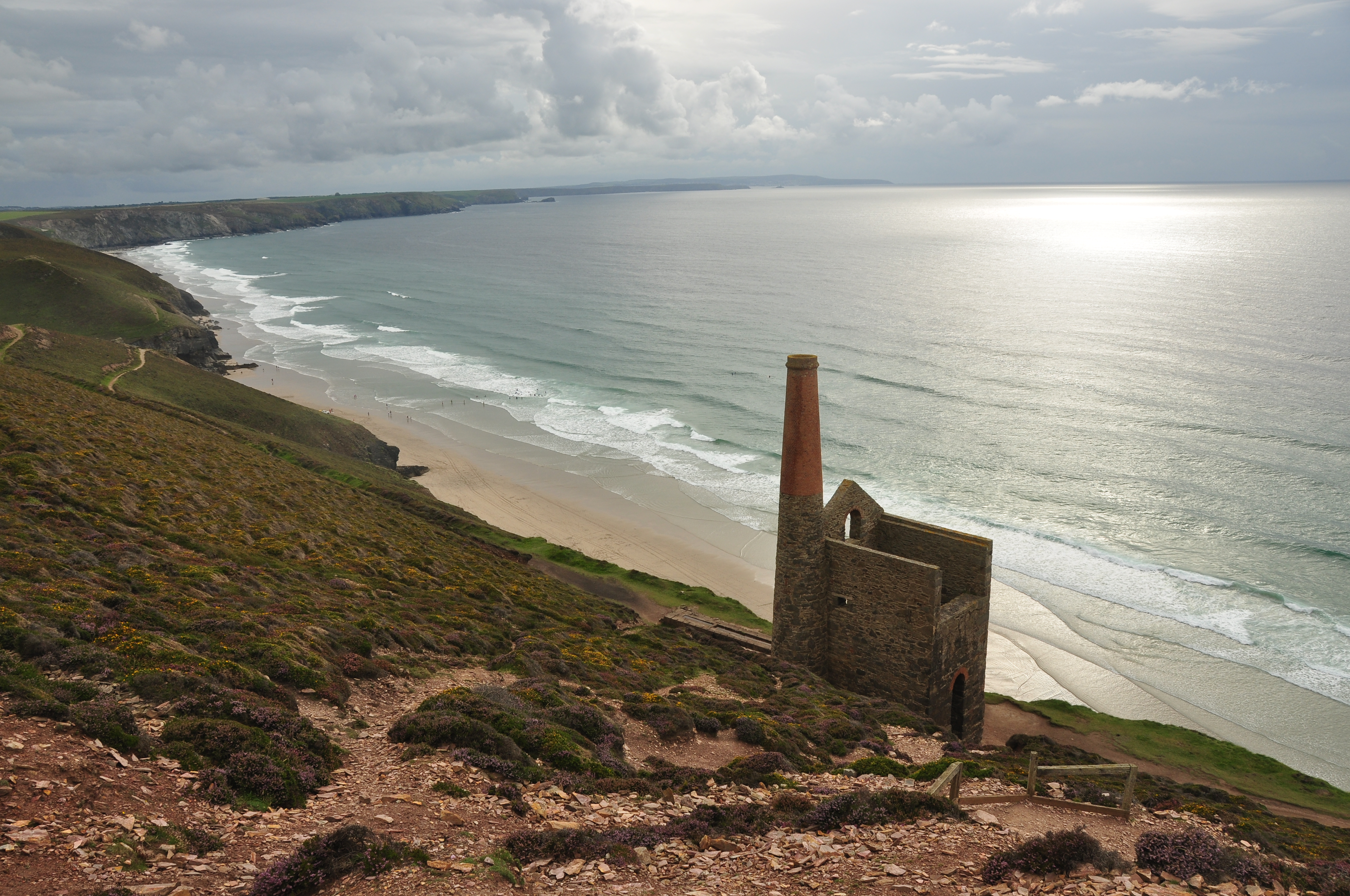
On this part of the Cornish coast we are firmly in mining territory, so much so that the makers of Poldark chose St Agnes Head as one of the locations for the TV series, using it to represent the Nampara Valley, part of the Poldark family’s estate.  Find out more about the locations used in my sister blog Britain On Page and Screen.  In order to soak up some of the Poldark atmosphere, park in the cark park and walk towards the coastguard’s lookout, then head along the coast in a westerly direction to the evocative Wheal Coates, a former tin mine which closed in 1889 and which now enjoys UNESCO World Heritage Site status.  Further east, between Trevaunance Cove and the village of St Agnes, you will find another notable mine called Wheal Friendly, which produced 160 tons of high grade copper ore between 1823 and 1825.

Trevaunance Cove is a short distance to the north of St Agnes.  It used to have an important harbour serving the local mines, but the harbour was destroyed by a terrible storm in 1915.  The beach here has plenty of sand exposed at low tide, and is popular with surfers.  St Agnes was a thriving village back in the mining years, with up to 1,000 people employed in the tin and copper mines, a time recalled in the local museum.  Among its historic streets is a stepped terrace of cottages, former ships captains’ houses, with the intriguing name of Stippy Stappy Lane.  Winston Graham, author of the Poldark novels, took the lane as inspiration for a lane in his fictional village of St Anne’s. Near the lane is yet another mine called West Wheal Kitty, which closed in 1930. 

Map of the area. 

File:Enginehouse at Wheal Coates (6116).jpg
Enginehouse at Wheal Coates (6116). Photo by Nilfanion, via Wikimedia Commons.