Labels

Aberdeenshire (21) Angus (4) antiquities (87) Argyll and Bute (35) Arran (7) art (37) birds (231) bridge (9) Caithness (12) Carmarthenshire (5) castle (164) Ceredigion (9) Channel Islands (13) Cheshire West and Cheshire (1) City and County of Swansea (1) City of Bristol (2) City of Edinburgh (4) Conwy (8) Cornwall (74) County Antrim (19) County Down (23) County Durham (3) County Londonderry (4) Cumbria (19) Denbighshire (2) Devon (48) diving (9) Dorset (18) Dumfries and Galloway (22) Dundee City (1) East Lothian (6) East Sussex (16) East Yorkshire (6) English Riviera (3) Essex (17) Fife (19) Flintshire (1) food (12) fossils (14) gardens (28) Ghosts (36) Glamorgan (1) Gower (7) Guernsey (4) Gwent (1) Gwynedd (19) Hampshire (13) Highland (72) Inner Hebrides (42) Inverclyde (5) Islay (8) Isle of Anglesey (14) Isle Of Man (7) Isle Of Wight (10) Isles of Scilly (3) Jersey (7) Kent (22) Lancashire (8) Lewis and Harris (7) lighthouse (62) Lincolnshire (8) Merseyside (8) Mid Glamorgan (1) mining (23) Moray (10) Mull (8) Norfolk (21) North Ayrshire (13) North Yorkshire (12) Northern Ireland (45) Northumberland (17) Orkney (10) Outer Hebrides (14) Pembrokeshire (27) pubs (50) Ross and Cromarty (20) Scotland (299) Scottish Borders (3) Shetland (14) shipwrecks (42) Skye (12) smuggling (48) Somerset (9) South Ayrshire (6) South Glamorgan (5) South Gloucestershire (2) Suffolk (18) surfing (92) Sutherland (16) Tyne and Wear (8) Wales (93) wartime (75) webcams (232) West Dunbartonshire (3) West Glamorgan (9) West Sussex (9)
Showing posts with label Caithness. Show all posts

Wednesday, 13 June 2012

CROSSKIRK AND REAY

Crosskirk is home to a ruined chapel called St Mary's, whose architectural style owes more to the incoming Norsemen of yore than to traditional Scottish styles. It was built around 1100 AD, making it one of the oldest churches in Caithness. The church is roofless, and stands in a walled burial ground affording delightful views of Crosskirk Bay. There are signs of even earlier human activity in the vicinity in the form of an 8th century broch, while to the south of the church is a healing well dedicated to St Mary.

The village of Reay is just to the south of Sandside Bay, whose dunes encroach on the village to the extent that its church was buried in sand for over a century. The church was rebuilt in the 18th century and now stands proud with an attractive whitewash tower. The Reay Stone, set in the wall of the chapel, has a relief carving of a cross and ornamental knot-work and probably dates from the 10th century. There were Pictish and Viking settlements in the bay which also succumbed to the dunes. Nestling among the backdrop to the bay is the Reay Golf Club. Scanning the skyline around here it is impossible to ignore the huge steel sphere of Dounreay nuclear power station. The station, which is being decommissioned, has caused environmental concerns about nuclear fuel particles which have escaped into the bay, so much so that the beach is regularly monitored for particles.

Map of the area.
Reay Golfcourse - geograph.org.uk - 10296. Photo by Dorcas Sinclair, via Wikimedia Commons.


Tuesday, 12 June 2012

THURSO

Thurso can seem like a city compared to the little villages that make up most of the settlements in this part of Scotland. It even emulates Edinburgh with a Princes Street. In fact, Thurso is mainland Britain's most northerly town, complete with the most northerly railway station. From its Norse beginnings - the name derives from the Old Norse for Bull's River - the town has grown to its present size largely as a result of the proximity of the Dounreay nuclear power station, now being decommissioned. The town's attractive seafront includes the restored fishing quarter of Fisherbiggins and a promenade offering views to Orkney. The bay is popular with windsurfers, and is used for international surfing competitions. Last year there was a suggestion that the bay would be the perfect laboratory for studying Scotland's seas. The nearby port of Scrabster serves as the main ferry departure point for the Orkneys.

Thurso Castle started off as a 12th century earthwork, but it went through two subsequent transformations: in the 17th century George, Earl of Caithness built a stone tower house on the site, then in the 19th century the tower was incorporated into a Scottish baronial mansion by Sir Tollemache Sinclair. The castle is now ruined, and closed to the public. Thurso's St Peters Church stands on the oldest church site in Caithness, dating originally from the first half of the 13th century. 

For a list of events in Thurso, follow this link.

Map of the area.


Thurso Bay. Photo by Michael Garlick, via Wikimedia Commons.

Sunday, 10 June 2012

CASTLETOWN

The streets of Glasgow may not be paved with gold, but what they are paved with is stone from the quarry at Castletown, as are the streets of Edinburgh. In fact the stone made it all the way to Melbourne, among other far-flung places, shipped out of the tiny harbour of Castlehill. At its height, there were 500 men working at the quarry, but sadly it closed in the 1920s due to competition from concrete, but the memory of the trade lives on in the form of the Flagstone Trail, which starts west of the harbour near the Heritage Centre. The Centre occupies a site which was formerly part of a farmstead on the Castlehill Estate, and its displays cover not only the flagstone industry, but other local activities and traditions. One of the locally grown crops, corn, used to be processed in the Castletown Mill, built in 1818. This is now disused and in a state of ruin, and is one of the sights along the Trail, along with the remains of the quarry, a dam, a water-wheel and a cutting yard. The village itself has a history dating back to the Iron Age, as evidenced by the presence of a broch nearby. One of its most imposing buildings is the Drill Hall, now used as a community centre.

Map of the area.


The Harbour Castletown - geograph.org.uk - 1817371. Photo by Glyn Baker, via Wikimedia Commons.

Tuesday, 5 June 2012

MEY

When one thinks of royal Scottish boltholes one's thoughts automatically veer towards Balmoral. However, there is a castle near the remote village of Mey in the far north of Scotland which in 1952 captured the imagination of the recently bereaved Queen Elizabeth, the Queen Mother. Hearing that Barrogill Castle, as it was then called, was destined for abandonment, she decided to save it, and it became her summer residence. Nowadays, the Castle and Gardens of Mey are open to visitors from the beginning of May to the end of September. The castle dates back to the 16th century, having been built by George, the 4th Earl of Caithness.

The Merry Men of Mey are not a group of whisky-sodden local males, but a treacherous coastal feature in the Pentland Firth, the stretch of water separating the Orkneys from the Scottish mainland. A tidal race which forms off the rocks known as the Men of Mey, the Merry Men at their most violent consist of large waves forming suddenly and coming from various directions, making this stretch of water very dangerous to negotiate.

Map of the area.
Castle of Mey 2. Photo by Thomas Froese, via Wikimedia Commons.


Wednesday, 11 April 2012

JOHN O'GROATS

The route from Lands End to John O'Groats has long been one of the holy grails for people seeking to break records, raise money for charity or simply fulfil a personal goal. The most favoured methods of travel between the two is by bike or on foot. In 1880 cycling companions H. Blackwell and C. A. Harman were the first known cyclists to attempt the ride, completing it in 13 days. This record was broken in 1885 by one J. Lennox, who managed 6 days and 16 hours. The following year, an 18-year-old called George Pilkington Mills broke the record twice, once on a penny farthing and once on a tricycle, achieving 5 days and 10 hours on the tricycle. And so it has gone on down the years, with ever faster times achieved courtesy of ever more high-tech machines. The current record is held by Gethin Butler, who made it in 1 day, 20 hours, 4 minutes and 20 seconds in 2001. Perhaps the most poignant achievement of a cyclist was that of the late Jane Tomlinson, who made the journey in 2003 while terminally ill with cancer (this was but one of her cycling achievements, which included a bike ride across America).

Then there are the walkers, who over the years have included a number of celebrities. Former cricketer Ian Botham was one of the best-known: he completed the walk for charity in 1985 following a chance visit to a children's ward. The first recorded walk between the two end points actually went in the other direction: brothers John and Robert Naylor made the trek south in 1871. Not all of the walking events were undertaken with charity in mind. In 1960, the holiday park entrepreneur Billy Butlin organised a road walking race from John O'Groats to Lands End which was entered by 700 competitors, and which offered a prize of £1000, bagged by 19-year-old Wendy Lewis. There is a wonderfully nostalgic piece of footage covering the event on the British Pathe website.

Finally, as is so often the case with such endeavours, there have been a fair number of oddballs making the trip over the years. In 2005 a golfer from Kent called David Sullivan walked the north-south route hitting golf balls all the way. In 2010 three skateboarders made the journey in 21 days, a record for skateboarding the route. A number of people have made the journey on ride-on lawnmowers, the first being Stuart Boreham in 1996. In 2009, John Carver made the trip by "flyke", a flying bike. Also in 2009, US Navy pilot Rick Ryan claimed the record for a wheelchair. In 2008, an enterprising pensioner made the most of the recently introduced free bus passes for the over-60s by making the journey up and back on public transport, for free!

Those who make the journey northwards are greeted by a roadside scattering of houses, hotels and shops.  Further down the road leading to the small harbour there is a complex of gift and craft shops and cafes with further accommodation options.  To gain a real sense of an end to end, one has to push on a bit further to Duncansby Head. Orca can sometimes be seen off the coast of this corner of Scotland.  Back in John O'Groats, the name of the village derives from the Dutchman Jan de Groot, who was charged with setting up a ferry service between the mainland and Orkney. The ferry which operates from the tiny harbour nowadays offers wildlife cruises around the coast and day tours to Orkney during the summer months. John O'Groats is a cheap date compared with its brash Cornish opposite number Lands End, with free parking, no 'attractions' with expensive entrance fees and no photographers lurking at the signpost ready to grab your money for the privilege of having your photo taken.  The day we visited, the experience was enhanced by the sound of bagpipes wafting through the air courtesy of a visiting piper.

Map of the area.


The John O'Groats Signpost - geograph.org.co.uk - 6979188. Photo by David Dixon, via Wikimedia Commons.

Monday, 9 April 2012

SINCLAIRS BAY

The Sinclair family name is so prominent in these parts that there is even a bay named after them. Sinclairs Bay is just to the north of Wick, with Noss Head Lighthouse marking its southern extreme. Near Noss Head are the remains of Castle Sinclair Girnigoe, one of the earliest seats of the Clan Sinclair, built in the late 15th century. The castle suffered a series of conflicts, but the cause of its final demise is unclear. There is a school of thought that Cromwell's troops started its demolition, as had been the case with other castles. The bay is fringed by a long, sandy beach, with the Burn of Lyth running into it halfway along. The village of Keiss is graced by another castle dating from around the late 16th century, built by George the 5th Earl of Caithness, and now partially ruined. It must have made an impressive sight in its heyday, towering above the clifftop. A little further north still, the village of Auckengill is home to the Northlands Viking Centre, which exhibits the Viking Heritage of Caithness, and goes back even further in time to the pre-Viking kingdom of the Catti.

Map of the area.

Keiss Castles. Photo by Fergus Mather, via Wikimedia Commons.


Sunday, 8 April 2012

WICK

The name Wick derives from the Norse word "vik", which means "bay". The layout of the town is medieval, although most of the buildings are 18th-century. One particular part of town known as Pulteneytown, a herring town which was designed by Scottish engineer Thomas Telford, was granted £1.5m from Historic Scotland a few years ago for regeneration, enabling the restoration of many of the area's beautiful buildings. In 2006 a street in Wick called Ebenezer Place made it into the Guinness Book of Records as the world's shortest street, trumping the previous holder of the record in Bacup, Lancashire. Wick suffered a tragedy during World War II, when bombs which were intended for the harbour instead hit a house, killing 21 civilians, including 11 children. The large number of children killed was in part due to the fact that it was the first day of the summer holiday, and there were many children playing outside at the time. A war memorial now marks the spot where the house stood.

There are a number of attractions in the town for visitors. Wick has its own distillery, the Old Pulteney Distillery, which produces a Single Malt Whisky. There is also a Heritage Centre covering many aspects of local life and history. Boat trips are available along the Caithness coast, allowing visitors to observe the coastline, castles and wildlife, which occasionally includes whales or dolphins. Old Wick Castle, dramatically situated on top of steep cliffs one mile south of the town, is thought to have been built in the late 12th/early 13th century. For the birdwatchers, there is the Wick River Walk, which includes a tidal estuary which is a haven for wading birds, while further inland small birds such as the sedge warbler and reed bunting can be observed.

Map of the area.

The Jetty and Lifeboat Station - geograph.org.uk - 479200. Photo by Stanley Howe, via Wikimedia Commons.


Thursday, 5 April 2012

WHALIGOE

The women in this part of Scotland in the 18th and 19th centuries must have had incredible stamina. At Whaligoe, a steep flight of up to 365 steps (estimates vary between 330 and 365) zigzags down to Whaligoe Haven, a small natural harbour. The steps were built in the late 1700s to facilitate the unloading of herring, in spite of the spot having been dismissed by Thomas Telford, who was prospecting the area, and who described this location as "a terrible spot". At the bottom of the steps is a platform where the fish were unloaded from the boats down below, and the fisherwomen, some of advanced years, would carry the fish up the steps in creels (wicker baskets) . Sometimes the fish would be salted in barrels part-way down the steps, in which case the fisherwomen would carry the salt down the steps, which must have been incredibly precarious. The ruins of the old salt store are still visible, as is the barking kettle, a stone cauldron which was filled with bark and cow urine and used to boil nets, while on the cliff top there is an old 19th century herring station. The name Whaligoe derives from "whale geo" or "inlet of whales", and this stretch of coast has a whole series of these "geos". A walk down the steps and back up makes an exhilarating coastal experience, especially when accompanied by the cacophany from the many nesting fulmars. Just inland of Whaligoe there is a 5,000-year-old burial tomb called the Cairn o'Get.

Map of the area.

File:Whaligoe Steps - geograph.org.uk - 893169.jpg
Whaligoe Steps - geograph.org.uk - 893169. Photo by Sylvia Duckworth, via Wikimedia Commons.

Tuesday, 3 April 2012

LYBSTER

Lybster owes its existence to a member of one of the prominent families around these parts, the Sinclairs. General Patrick Sinclair, a local landowner, started Lybster as a planned village. He named part of the wide main street Quatre Bras (Four Arms) in honour of his sons, who fought at Waterloo. The village, which was once a major herring port, has a distinctive harbour, with a small inner harbour providing extra protection within the bigger harbour, which lies at the mouth of the Reisgill Burn. The original harbour was designed to take over 100 fishing boats, but at the height of the herring trade here there were nearly 300 boats operating in the area, with Germany being a particularly big export market for the local catch. Many of the coastal communities around Britain have a particular weather event which stands out in the collective past, and in Lybster's case it was a severe storm in 1847 during which seven local fishermen lost their lives and the harbour was badly damaged. The harbour was repaired and improved but there was further storm damage 30 years later. Lybster's herring trade was in decline by the end of the century.

There are some beautifully restored buildings by the side of Lybster harbour which house a visitor centre called Waterlines with an exhibition about the history, geology, wildlife etc. of the area, and a cafe downstairs. The exhibition includes a remote CCTV trained on the breeding bird colonies of the nearby cliffs which can be used to observe the birds going about their business.  Lybster's diminutive golf course is one of the shortest 9-hole golf courses in Scotland.  A book written by the local author Neil Gunn (see Dunbeath post) called The Silver Darlings was made into a film in 1947, which was partly shot in Lybster.

Map of the area.


Lybster Harbour - geograph.org.uk - 2568548. Photo by Bob Jones, via Wikimedia Commons.

Sunday, 1 April 2012

LATHERON

The name Gunn (see the previous post about the author Neil Gunn) is prevalent around these parts, and there is a Heritage Centre in Latheron's 18th century kirk devoted to the Clan Gunn, a powerful Caithness family, which makes an extraordinary claim, namely that one of the Gunns reached the Americas a century before Christopher Columbus. The Gunns were Norse in origin and decided to settle in this northeast corner of Scotland when they came on one of their raids. There are Bronze Age standing stones to the north of the village, and nearby Latheronwheel has a cute little harbour with a path leading to clifftop walks.  Just outside the village is the Buldoo Standing Stone, the tallest in Caithness, standing at just over twelve and a half feet high and dating from the Bronze Age.

Map of the area.

Latheron, the old church - geograph.org.uk - 596902. Photo by Chris Downer, via Wikimedia Commons.


Saturday, 31 March 2012

DUNBEATH

Perched on the cliff just over a mile south of Dunbeath is an impressive whitewashed building - this is Dunbeath Castle, which once belonged to the Sinclair Clan, who replaced the original building with a four-storey tower house in 1620. The castle saw action during the Wars Of The Three Kingdoms, part of a spate of civil wars fought in England, Scotland and Ireland, when it was attacked by Royalist forces. As the castle is still occupied, it is not open to the public. However, there are some cottages and lodges within the Dunbeath Estate available for holiday lets.

Dunbeath itself is, like Berriedale, a small village nestling at the mouth of a river. The village has a heritage centre showcasing the history and wildlife of the area. The history of the village stretches back to the Iron Age, with many brochs - hollow-walled, drystone structures. There is also an early medieval monastic site. Bookworms who want to get a feel for the area should look up the author Neil Gunn, who died in 1973. He was born in Dunbeath, and many of his novels are set in Dunbeath and the surrounding area. There is a statue overlooking the harbour called Kenn And The Salmon in memory of Gunn.

Map of the area.

Water of Dunbeath - geograph.org.uk - 481675. Photo by Stanley Howe, via Wikimedia Commons.


Wednesday, 28 March 2012

BERRIEDALE

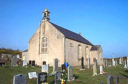
Reached by a twisty roller-coaster of a road, Berriedale is a tiny village at the base of a valley formed from two converging rivers, the Berriedale Water and the Langwell Water. Its collection of buildings of varying degrees of agedness includes the remains of a castle thought to have originated in Viking times; the Berriedale Church of Scotland, built in 1826, a grey, squat little church surrounded by a scattering of graves; the whitewashed Old Smithy, with a curious antler decoration on the outside formed from real stags' antlers; and two crenellated towers in an elevated position outside the village which were designed to act as mini lighthouses for showing fishermen where the mouth of the river was. The towers were commissioned by the Duke of Portland, hence their nickname the "Duke's Candlesticks". Last year it was reported that a row of fishermen's cottages in the village known as the Shore Cottages were to be restored with the help of funding to the tune of £600,000 from the Landmark Trust.

Map of the area.

Berriedale Church - geograph.org.uk - 225480. Photo by Bill Henderson, via Wikimedia Commons.