Labels

Aberdeenshire (21) Angus (4) antiquities (87) Argyll and Bute (35) Arran (7) art (37) birds (231) bridge (9) Caithness (12) Carmarthenshire (5) castle (165) Ceredigion (9) Channel Islands (13) Cheshire West and Cheshire (1) City and County of Swansea (1) City of Bristol (2) City of Edinburgh (4) Conwy (8) Cornwall (74) County Antrim (19) County Down (23) County Durham (3) County Londonderry (4) Cumbria (19) Denbighshire (2) Devon (48) diving (7) Dorset (18) Dumfries and Galloway (22) Dundee City (2) East Lothian (6) East Sussex (16) East Yorkshire (6) English Riviera (3) Essex (17) Fife (19) Flintshire (1) food (13) fossils (14) gardens (28) Ghosts (35) Glamorgan (1) Gower (7) Guernsey (4) Gwent (1) Gwynedd (19) Hampshire (13) Highland (72) Inner Hebrides (42) Inverclyde (5) Islay (8) Isle of Anglesey (14) Isle Of Man (7) Isle Of Wight (10) Isles of Scilly (3) Jersey (7) Kent (22) Lancashire (8) Lewis and Harris (7) lighthouse (62) Lincolnshire (8) Merseyside (8) Mid Glamorgan (1) mining (23) Moray (10) Mull (8) Norfolk (21) North Ayrshire (13) North Yorkshire (12) Northern Ireland (45) Northumberland (17) Orkney (10) Outer Hebrides (14) Pembrokeshire (27) pubs (47) Ross and Cromarty (20) Scotland (300) Scottish Borders (3) Shetland (14) shipwrecks (42) Skye (12) smuggling (48) Somerset (9) South Ayrshire (6) South Glamorgan (5) South Gloucestershire (1) Suffolk (18) surfing (83) Sutherland (16) Tyne and Wear (10) Wales (93) wartime (75) webcams (232) West Dunbartonshire (3) West Glamorgan (9) West Sussex (9)

Friday 23 September 2016

HAYLE


The geography of Hayle and its surroundings is dominated by the estuary of the River Hayle, which flows into St Ives Bay.  The town has an industrial past stretching all the way back to Neolithic times, when it was an important centre for the tin industry.  The port serviced trade with nations as far away as the Eastern Mediterranean, a fact which is proven by pieces of pottery from that part of the world found in the area.  More recently, the town played an important 
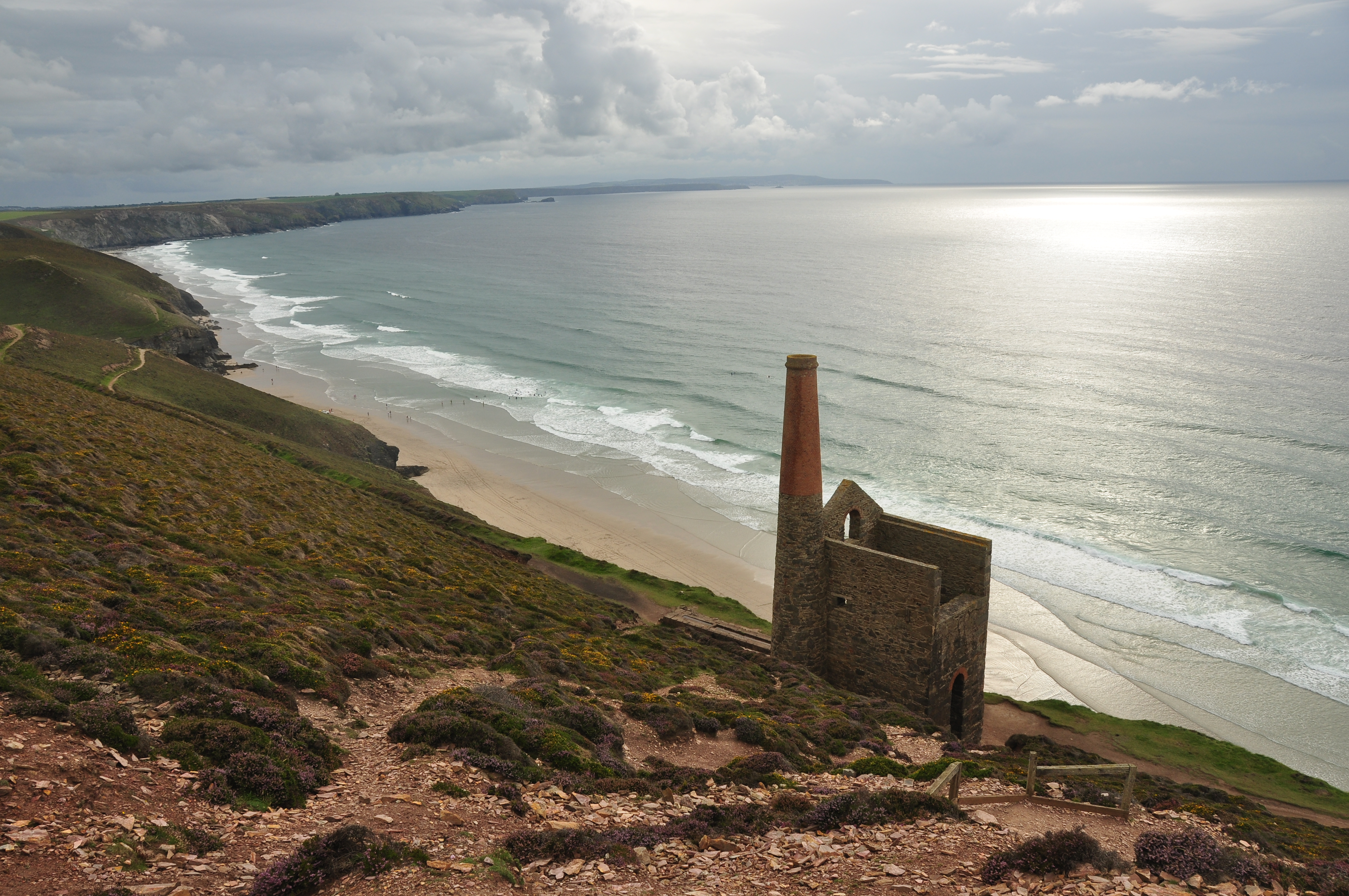
role in the Cornish mining industry, with the foundries of Harvey & Co making the machinery which kept the mines going.  A reminder of that time remains in the form of Foundry Square, with a railway viaduct towering over it – the square used to be the western terminus of the Hayle Railway.  The Hayle Heritage Centre tells the story of the area's past industrial history.

The estuary is a magnet for birdwatchers, being frequented by rare species such as great northern divers.  More exotic species of bird can be found in the long-standing tourist attraction Paradise Park, just off the road leading round towards St Ives.  The town itself has always struck me as rather strung-out, mainly running alongside the main thoroughfare.  Recently the assortment of small shops, food outlets and other businesses were joined by a massive Asda superstore, dominating the waterfront to the extent that my husband and I were totally disoriented the last time we drove through the town.  

Live streaming webcam view from Hayle Beach, courtesy of The Penellen Hotel.

Map of the area. 

File:Hayle viaduct - geograph.org.uk - 1880018.jpg
Hayle viaduct - geograph.org.uk - 1880018. Photo by Roger Geach, via Wikimedia Commons.

Saturday 17 September 2016

GODREVY POINT AND GWITHIAN


A few years ago, on one of our many trips down to Cornwall to visit the folks back home, my husband and I turned off the A30 and made our way to Gwithian, from where we followed a National Trust sign along a minor road around to a parking area with a wonderful view of Godrevy Lighthouse.  I had only ever seen the lighthouse from a distance before.  It was a lovely sunny day, and with the lighthouse in one direction and endless stretches of surf  looking towards St Ives in the other, I was captivated by the view.  Godrevy Point is an excellent spot for looking out for dolphins and porpoises, and Mutton Cove is home to a large colony of Grey Seals.  The lighthouse was started in 1858 and lies on a small island just off Godrevy Point.  The main purpose of the lighthouse is to warn seafarers off a reef called the Stones reef, a long-standing hazard to shipping.

Gwithian beach is backed by sand dunes and is set among the Gwithian Towans Local Nature Reserve, also designated a Site of Special Scientific Interest for its diverse flora and fauna, including skylarks and butterflies, guillemots, razorbills and cormorants, while Common Seals can be seen near the beach.  The word ‘Towan’ comes from the Cornish ‘tewyn’, meaning sandhill or dune.  The surfers who flock here are catered for by a couple of laid-back cafes, one of which occupies a former 19th century coastguard lookout.  There are also rock pools and caves for the kids to explore.  

Map of the area


Godrevy Lighthouse, by Barbara Ashley


Sunday 11 September 2016

PORTHTOWAN AND PORTREATH


The area around the small seaside village of Porthtowan used to be alive with the sound of mining, dominated by the Wheal Towan copper mine.  The mine is said to have brought its owner Ralph Allen Daniell of Trelissick the equivalent today of £10,000 a week, making him the JR Ewing of Cornwall.  The old tramways that used to be used to transport the copper and tin ores to the harbours of Portreath and St Agnes are being converted into paths for cyclists and walkers.  Porthtowan’s huge sandy beach drew hordes of Victorian visitors from the inland towns of Redruth and Camborne, and it remains a popular beachgoing resort to this day.  Known for its powerful swell, creating dramatic ‘hollow’ waves, it is a magnet for the more serious brand of surfers.  The beach has Blue Flag status, and there is a range of places to eat and drink.

Portreath’s narrow harbour was once used for trading with Wales, importing Welsh coal and exporting copper to Swansea for smelting, but the only economic activity nowadays is fishing.  The sandy beach, with its stream running down to the sea, is popular with families and surfers and bodyboarders alike.  Portreath offers some unique conditions for bodyboarding with The Vortex, a right hand reef break which peels off the harbour wall – strictly for experienced bodyboarders only.  There is a small selection of places to eat and drink, and a range of holiday accommodation, as well as leisure facilities such as squash and outdoor bowls.   One of the tramways which used to be used for transporting ore from the mines has been made into a coast to coast cycle path called the Mineral Tramways Coast to Coast, heading inland from Portreath to Devoran on the south coast.  Walkers who fancy a challenge can take the sometimes strenuous coastal path leading in a southwesterly direction to Bassets Cove.  

Webcam view of the beach.

Map of the area. 


File:Portreath Beach - geograph.org.uk - 189848.jpg
Portreath Beach - geograph.org.uk - 189848. Photo by Tony Atkin, via Wikimedia Commons.

Saturday 3 September 2016

TREVAUNANCE COVE AND ST AGNES


On this part of the Cornish coast we are firmly in mining territory, so much so that the makers of Poldark chose St Agnes Head as one of the locations for the TV series, using it to represent the Nampara Valley, part of the Poldark family’s estate.  Find out more about the locations used in my sister blog Britain On Page and Screen.  In order to soak up some of the Poldark atmosphere, park in the cark park and walk towards the coastguard’s lookout, then head along the coast in a westerly direction to the evocative Wheal Coates, a former tin mine which closed in 1889 and which now enjoys UNESCO World Heritage Site status.  Further east, between Trevaunance Cove and the village of St Agnes, you will find another notable mine called Wheal Friendly, which produced 160 tons of high grade copper ore between 1823 and 1825.

Trevaunance Cove is a short distance to the north of St Agnes.  It used to have an important harbour serving the local mines, but the harbour was destroyed by a terrible storm in 1915.  The beach here has plenty of sand exposed at low tide, and is popular with surfers.  St Agnes was a thriving village back in the mining years, with up to 1,000 people employed in the tin and copper mines, a time recalled in the local museum.  Among its historic streets is a stepped terrace of cottages, former ships captains’ houses, with the intriguing name of Stippy Stappy Lane.  Winston Graham, author of the Poldark novels, took the lane as inspiration for a lane in his fictional village of St Anne’s. Near the lane is yet another mine called West Wheal Kitty, which closed in 1930. 

Map of the area. 

File:Enginehouse at Wheal Coates (6116).jpg
Enginehouse at Wheal Coates (6116). Photo by Nilfanion, via Wikimedia Commons.