Labels

Aberdeenshire (21) Angus (4) antiquities (87) Argyll and Bute (35) Arran (7) art (37) birds (231) bridge (9) Caithness (12) Carmarthenshire (5) castle (165) Ceredigion (9) Channel Islands (13) Cheshire West and Cheshire (1) City and County of Swansea (1) City of Bristol (2) City of Edinburgh (4) Conwy (8) Cornwall (74) County Antrim (19) County Down (23) County Durham (3) County Londonderry (4) Cumbria (19) Denbighshire (2) Devon (48) diving (9) Dorset (18) Dumfries and Galloway (22) Dundee City (2) East Lothian (6) East Sussex (16) East Yorkshire (6) English Riviera (3) Essex (17) Fife (19) Flintshire (1) food (13) fossils (14) gardens (28) Ghosts (35) Glamorgan (1) Gower (7) Guernsey (4) Gwent (1) Gwynedd (19) Hampshire (13) Highland (72) Inner Hebrides (42) Inverclyde (5) Islay (8) Isle of Anglesey (14) Isle Of Man (7) Isle Of Wight (10) Isles of Scilly (3) Jersey (7) Kent (22) Lancashire (8) Lewis and Harris (7) lighthouse (62) Lincolnshire (8) Merseyside (8) Mid Glamorgan (1) mining (23) Moray (10) Mull (8) Norfolk (21) North Ayrshire (13) North Yorkshire (12) Northern Ireland (45) Northumberland (17) Orkney (10) Outer Hebrides (14) Pembrokeshire (27) pubs (47) Ross and Cromarty (20) Scotland (300) Scottish Borders (3) Shetland (14) shipwrecks (42) Skye (12) smuggling (48) Somerset (9) South Ayrshire (6) South Glamorgan (5) South Gloucestershire (1) Suffolk (18) surfing (84) Sutherland (16) Tyne and Wear (8) Wales (93) wartime (75) webcams (232) West Dunbartonshire (3) West Glamorgan (9) West Sussex (9)

Friday, 29 June 2012

BALNAKEIL

Balnakeil Bay is separated from Sango Bay by Faraid Head. The village has a ruined 17th century church with a tombstone commemorating a highwayman who killed eighteen people. The tombstone is decorated with a skull and crossbones and is built into a niche in a wall, supposedly as protection against enemies who might be tempted to desecrate the grave. The Balnakeil Craft Village, where visitors can watch craftsmen creating leather goods, ceramics and other products, is housed in an unusual set of ex-military buildings which once formed part of an early warning system. Balnakeil House was built in the 18th century on top of the remains of a summer palace which belonged to the Bishops of Caithness. This impressive building is now available to rent, which would make for an amazing stay for a large party, standing above a beautiful bay with wonderful views. The beach at Balnakeil Bay is wide, with brilliant white sands, backed by dunes. There is a 3 mile walk through the dunes which border the eastern side of the bay leading to Faraid Head, where nesting puffins and other sea birds can be observed.

Map of the area.

Balnakeil beach - geograph.org.uk - 435872. Photo by Bob Jones, via Wikimedia Commons.


Wednesday, 27 June 2012

DURNESS

In the early 1950s a young boy from Liverpool used to frequent Durness every summer, visiting his cousin Stan whose family had moved to the area. The boy loved his holidays there and used to play with the local kids. However, in sharp contrast to those idyllic times the boy was destined to meet a violent end at age 40 in New York, shot dead outside his home in front of his wife. The boy was John Lennon, and once he had found his fame and fortune he harboured a desire to buy some land in Scotland; in fact the Durness estate was up for sale at one point, but Lennon was too slow and missed out on buying it. Tragically, he died before achieving his aim of owning his own Scottish paradise.

One only has to look at the beautiful Sango Bay on which Durness is located and it is easy to see why Lennon fell in love with the place. Nearby Smoo Cave, which can be reached on foot independently, or as a tour partly by boat, is a sea cave believed to have been occupied by humans 5,000 years ago. The village itself has a scattering of tourist facilities, including a Tourist Information Centre and a wonderfully located camping and caravan site overlooking the bay. The village, being close to Cape Wrath, is the most north-westerly village in mainland Scotland.

Map of the area.

Sango Bay - geograph.org.uk - 835042. Photo by Anne Burgess, via Wikimedia Commons.


Monday, 25 June 2012

LOCH ERIBOLL

Loch Eriboll is the widest and deepest of the inlets to be found on the north coast of Scotland. The loch is a welcome refuge from the often perilous seas off Cape Wrath and in the Pentland Firth. During the Second World War the loch's sheltered position was made use of by the North Atlantic convoys, who used it as an assembly point, although the crew members dubbed it "Loch 'Orrible". There is a small island in the middle of the Loch which was used as target practice by bombers destined to destroy the German battleship Tirpitz, which would take place in a similarly shaped Norwegian fjord. At the end of the war, German U-boats surrendered to the British Navy on Loch Eriboll. The area around the loch was inhabited as early as the Bronze Age, and there are still some remains from that time.

Map of the area.
Loch Eriboll - geograph.org.uk - 931652. Photo by Sarah Charlesworth, via Wikimedia Commons.


Sunday, 24 June 2012

TONGUE

The north coast of Scotland is pockmarked with bays and inlets, and one of the deepest and narrowest of the latter is the Kyle of Tongue. Once upon a time drivers were forced to wind their way around a 10-mile stretch of road to get from one side of the Kyle to another, but there is now a bridge to help them on their way. In the old days an alternative means of crossing the Kyle was offered: a "large flat boat" which was moved from one side to the other "by means of a windlass and chain". The boat was capable of carrying a carriage "without the horses being unharnessed". *

In 1746, in the run-up to Culloden, there was a battle between a royal naval frigate HMS Sheerness and a ship called Hazard, which was carrying over £13,000 in gold coins to fund Bonnie Prince Charlie's rebellion. The Hazard had fled into the Kyle of Tongue in order to evade its pursuers, and the gold was thrown into the loch before the crew were captured. To the north of the village is Tongue House, which the Clan MacKay moved to after abandoning their former seat, Castle Varrich. Castle Varrich, which is believed to occupy the site of a former Norse stronghhold, offers wonderful views of Ben Loyal and Ben Hope mountains, making it an attractive place to visit. The village of Tongue has a church, St Andrews, dating from the late 17th century. The church has a feature which is commonly found around these parts called a "laird's loft", which is a raised gallery where the laird and his familiy used to worship.

*Guide to the Highlands and Islands of Scotland, Including Orkney, by George and Peter Anderson, 1842.

Map of the area.
Tongue, Caisteal Bharraich and the Kyle of Tongue - geograph.org.uk - 597543. Photo by Chris Downer, via Wikimedia Commons.


Wednesday, 20 June 2012

BETTYHILL

One of the most controversial episodes in the history of Scotland was that of the Highland Clearances, by which entire communities were forcibly moved away from their homes by aristocratic landowners bent on agricultural revolution. The people affected ended up in the Scottish lowlands, on the coast, or even in North America. Bettyhill on the north coast of Scotland was the result of such clearances, populated by people displaced from the Strathnaver valley - the valley of the River Naver - which formed part of the estate of the Countess of Sutherland and her husband. The first name of the Countess was Elizabeth, and it is thought that this was where the name Bettyhill came from.

The village overlooks the sand dunes of Torrisdale Bay and Farr Bay with its brilliant golden sand. Those who want to find out more about the Clearances should head to the Strathnaver Museum, housed within an 18th-century church. The museum also has displays on Strathnaver's archaeological sites, which include ancient brochs and cairns and the remains of a pre-Clearance village. The churchyard is notable for the Farr Stone, a Celtic carved cross-slab from the 9th century. Nature lovers should head for the west bank of the Naver estuary, where the Invernaver National Nature Reserve includes mountain plants which have strayed almost to sea level.

Map of the area.
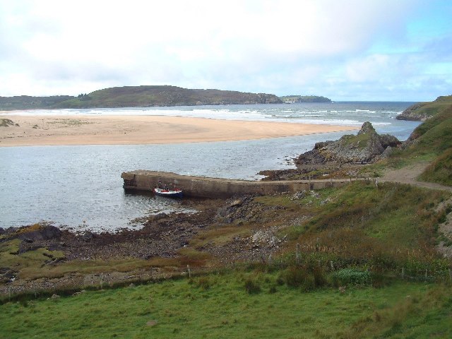
Bettyhill Jetty - geograph.org.uk - 24559. Photo by Bob Jones, via Wikimedia Commons.


Monday, 18 June 2012

MELVICH BAY

The Halladale River ends its route northwards at the sandy Melvich Bay, where the villages of Melvich and Portskerra run into each other. On the east bank of the river is Bighouse Lodge and Estate, built in 1765 and a former home of the chief of the Clan MacKay. Nowadays it offers sumptuous accommodation, along with a variety of outdoor pursuits. The saddest sight hereabouts is the Drowning Memorial, bearing the names of local men who have drowned while fishing over the years. It stands as a constant reminder and warning about the treacherous seas off this coast. The many drownings which have occurred here include a disaster in 1918, when many young men from the area were away fighting in the First World War, meaning that any fishing was mostly done by elderly men who were normally engaged in other activities. The day of the disaster started out as a beautiful hot summer's day, but a ferocious storm moved in while the men were out at sea, killing seven of them. One boat returned with nobody on board. The disaster was retold as part of a Five Minute Theatre event organised by the National Theatre of Scotland last year, and had an airing on the web.

Map of the area.
Portskerra Jetty - geograph.org.uk - 257053. Photo by Phil Williams, via Wikimedia Commons.


Wednesday, 13 June 2012

CROSSKIRK AND REAY

Crosskirk is home to a ruined chapel called St Mary's, whose architectural style owes more to the incoming Norsemen of yore than to traditional Scottish styles. It was built around 1100 AD, making it one of the oldest churches in Caithness. The church is roofless, and stands in a walled burial ground affording delightful views of Crosskirk Bay. There are signs of even earlier human activity in the vicinity in the form of an 8th century broch, while to the south of the church is a healing well dedicated to St Mary.

The village of Reay is just to the south of Sandside Bay, whose dunes encroach on the village to the extent that its church was buried in sand for over a century. The church was rebuilt in the 18th century and now stands proud with an attractive whitewash tower. The Reay Stone, set in the wall of the chapel, has a relief carving of a cross and ornamental knot-work and probably dates from the 10th century. There were Pictish and Viking settlements in the bay which also succumbed to the dunes. Nestling among the backdrop to the bay is the Reay Golf Club. Scanning the skyline around here it is impossible to ignore the huge steel sphere of Dounreay nuclear power station. The station, which is being decommissioned, has caused environmental concerns about nuclear fuel particles which have escaped into the bay, so much so that the beach is regularly monitored for particles.

Map of the area.
Reay Golfcourse - geograph.org.uk - 10296. Photo by Dorcas Sinclair, via Wikimedia Commons.


Tuesday, 12 June 2012

THURSO

Thurso can seem like a city compared to the little villages that make up most of the settlements in this part of Scotland. It even emulates Edinburgh with a Princes Street. In fact, Thurso is mainland Britain's most northerly town, complete with the most northerly railway station. From its Norse beginnings - the name derives from the Old Norse for Bull's River - the town has grown to its present size largely as a result of the proximity of the Dounreay nuclear power station, now being decommissioned. The town's attractive seafront includes the restored fishing quarter of Fisherbiggins and a promenade offering views to Orkney. The bay is popular with windsurfers, and is used for international surfing competitions. Last year there was a suggestion that the bay would be the perfect laboratory for studying Scotland's seas. The nearby port of Scrabster serves as the main ferry departure point for the Orkneys.

Thurso Castle started off as a 12th century earthwork, but it went through two subsequent transformations: in the 17th century George, Earl of Caithness built a stone tower house on the site, then in the 19th century the tower was incorporated into a Scottish baronial mansion by Sir Tollemache Sinclair. The castle is now ruined, and closed to the public. Thurso's St Peters Church stands on the oldest church site in Caithness, dating originally from the first half of the 13th century. 

For a list of events in Thurso, follow this link.

Map of the area.


Old St Peters Church


Sunday, 10 June 2012

CASTLETOWN

The streets of Glasgow may not be paved with gold, but what they are paved with is stone from the quarry at Castletown, as are the streets of Edinburgh. In fact the stone made it all the way to Melbourne, among other far-flung places, shipped out of the tiny harbour of Castlehill. At its height, there were 500 men working at the quarry, but sadly it closed in the 1920s due to competition from concrete, but the memory of the trade lives on in the form of the Flagstone Trail, which starts west of the harbour near the Heritage Centre. The Centre occupies a site which was formerly part of a farmstead on the Castlehill Estate, and its displays cover not only the flagstone industry, but other local activities and traditions. One of the locally grown crops, corn, used to be processed in the Castletown Mill, built in 1818. This is now disused and in a state of ruin, and is one of the sights along the Trail, along with the remains of the quarry, a dam, a water-wheel and a cutting yard. The village itself has a history dating back to the Iron Age, as evidenced by the presence of a broch nearby. One of its most imposing buildings is the Drill Hall, now used as a community centre.

Map of the area.


© 2003, Bob Jones, via Wikimedia Commons


The Harbour Castletown - geograph.org.uk - 1817371. Photo by Glyn Baker, via Wikimedia Commons.

Thursday, 7 June 2012

DUNNET HEAD

John O'Groats may be most people's idea of the end of the road for those heading northwards through Scotland, but in fact Dunnet Head is the most northerly point on Britain's mainland, with the nearest point of the Orkneys less than 7 miles away. The lighthouse at Dunnet Head was visited by the Queen Mother on one of her many visits to the area, and she was given a guided tour and had tea with the lighthouse keeper. The lighthouse was automated in 1989, and as a sign of the times is now remotely monitored from Edinburgh. The RSPB reserve here is home to a variety of seabirds, including puffins and razorbills. Spring is a particularly fascinating time to visit, as the birds set about their courtship rituals and their nestbuilding. Out at sea, killer whales are often sighted. There are also wartime relics here in the form of disused lookouts which were used during World War II to defend Scapa Flow. The village of Dunnet stands between St John's Loch to the north, and Dunnet Bay with its long sandy beach to the south. Half a mile from the village is the Seadrift Visitor Centre with displays explaining the nature of the area. Recently there was much consternation on the part of local people at the news that there was a proposal to build a wind turbine on Dunnet Head. One despairs at the thought of yet another beautiful place being desecrated by these wretched things.

Map of the area.


Tuesday, 5 June 2012

MEY

When one thinks of royal Scottish boltholes one's thoughts automatically veer towards Balmoral. However, there is a castle near the remote village of Mey in the far north of Scotland which in 1952 captured the imagination of the recently bereaved Queen Elizabeth, the Queen Mother. Hearing that Barrogill Castle, as it was then called, was destined for abandonment, she decided to save it, and it became her summer residence. Nowadays, the Castle and Gardens of Mey are open to visitors from the beginning of May to the end of September. The castle dates back to the 16th century, having been built by George, the 4th Earl of Caithness.

The Merry Men of Mey are not a group of whisky-sodden local males, but a treacherous coastal feature in the Pentland Firth, the stretch of water separating the Orkneys from the Scottish mainland. A tidal race which forms off the rocks known as the Men of Mey, the Merry Men at their most violent consist of large waves forming suddenly and coming from various directions, making this stretch of water very dangerous to negotiate.

Map of the area.
Castle of Mey 2. Photo by Thomas Froese, via Wikimedia Commons.


Monday, 4 June 2012

FOULA

Foula is the most remote inhabited island in the British Isles, but is visible from miles around standing proud from the sea. The island has five peaks: Da Noup, Hamnafield, Da Sneug, Da Kame, and Soberlie. Foula has been inhabited since Neolithic times, and the present day inhabitants cling to a coastal strip around the island's eastern edge in a scattering of settlements. The island is rich in sea bird colonies, and for this reason plus the blanket bog which forms part of the terrain it has been designated a Site of Special Scientific Interest. Foula is reachable by air, as it has its own airstrip, and there are also sea connections. What with depopulation over the years, there are only around 30 people left on the island now, and there has been talk of evacuation of the remaining populace, along the lines of what happened with St Kilda, but for now the inhabitants continue to eke out a living from their farming and from birdwatching tourism, making use of a special green renewable energy system for their electricity supply.

Map of Foula.


Foula IMG 6581 (14737896534). Photo by Ronnie Robertson, via Wikimedia Commons.

Saturday, 2 June 2012

FETLAR

Fetlar is known as the Garden of Shetland due to its exceptionally green appearance. The Vikings were so impressed with the island's fertility that the name they bestowed on it was the Viking version of "fat land", from which the present name derives. Only around 70 people share the island with the birds and animals which include the much sought-after red-necked phalarope whose "modern marriage" style of living has the male looking after the chicks while the female goes off and does her own thing, including playing the field! Other birds include arctic skuas and storm petrels, and there are otters and seals around the island, while if you're really lucky you could spot killer whales out at sea.. A seminal moment in the island's ornithological history came in 1967 when a pair of snowy owls started breeding there, an event which led to a large part of the island being declared an RSPB reserve. Sadly, there are no longer any owls resident on Fetlar. The main settlement on the island is Houbie, where the Fetlar Interpretive Centre has exhibitions on the history, heritage and archaeology of the island.

Live webcam feed from Fetlar.

Map of the island.

Houlls geo, Fetlar - geograph.org.uk - 335137. Photo by Tom Pennington, via Wikimedia Commons.