Labels

Aberdeenshire (21) Angus (4) antiquities (87) Argyll and Bute (35) Arran (7) art (37) birds (231) bridge (9) Caithness (12) Carmarthenshire (5) castle (165) Ceredigion (9) Channel Islands (13) Cheshire West and Cheshire (1) City and County of Swansea (1) City of Bristol (2) City of Edinburgh (4) Conwy (8) Cornwall (74) County Antrim (19) County Down (23) County Durham (3) County Londonderry (4) Cumbria (19) Denbighshire (2) Devon (48) diving (9) Dorset (18) Dumfries and Galloway (22) Dundee City (2) East Lothian (6) East Sussex (16) East Yorkshire (6) English Riviera (3) Essex (17) Fife (19) Flintshire (1) food (13) fossils (14) gardens (28) Ghosts (35) Glamorgan (1) Gower (7) Guernsey (4) Gwent (1) Gwynedd (19) Hampshire (13) Highland (72) Inner Hebrides (42) Inverclyde (5) Islay (8) Isle of Anglesey (14) Isle Of Man (7) Isle Of Wight (10) Isles of Scilly (3) Jersey (7) Kent (22) Lancashire (8) Lewis and Harris (7) lighthouse (62) Lincolnshire (8) Merseyside (8) Mid Glamorgan (1) mining (23) Moray (10) Mull (8) Norfolk (21) North Ayrshire (13) North Yorkshire (12) Northern Ireland (45) Northumberland (17) Orkney (10) Outer Hebrides (14) Pembrokeshire (27) pubs (47) Ross and Cromarty (20) Scotland (300) Scottish Borders (3) Shetland (14) shipwrecks (42) Skye (12) smuggling (48) Somerset (9) South Ayrshire (6) South Glamorgan (5) South Gloucestershire (1) Suffolk (18) surfing (84) Sutherland (16) Tyne and Wear (8) Wales (93) wartime (75) webcams (232) West Dunbartonshire (3) West Glamorgan (9) West Sussex (9)

Wednesday, 31 October 2012

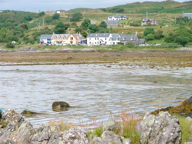
LOCH NAN UAMH

Bonnie Prince Charlie has been popping up all over the place during my virtual meander around the Scottish coast, but few places can rival Loch Nan Uamh for the significance of their link to the Prince. It was here that Charles Edward Stuart landed at the start of the 1745 rebellion, and it was also here that he finally departed for France 14 months later after the ill-fated escapade was abandoned following the defeat at Culloden. There is a cave on the loch, below Arisaig House (now a hotel), where the Prince and his fellow fugitives hid from the English redcoats. There is a memorial cairn on the shore of the loch marking the spot where the Prince landed. Harking back to much earlier times, there is an Iron Age fort on a headland to the south; the fort is unusual in that the stones used to build it became "vitrified" probably due to intense heat from the accidental burning of the timber used to strengthen the walls. The other major feature of the loch, at its head, is the Gleann Mama Viaduct, built for the West Highland Railway and boasting eight arches. The viaduct provides passengers on the Jacobite, or "Harry Potter train" with wonderful views out over the loch and its beautiful shoreline.

Map of the area.

Loch nan Uamh - geograph.org.uk - 412224. Photo by Dave Fergusson, via Wikimedia Commons.


Monday, 29 October 2012

CANNA AND SANDAY

Canna and Sanday are two separate islands, but they are linked by a road and sandbanks at low tide. Canna is the larger of the two, but even it is only 4.3 miles long and 0.9 miles wide, dwarfed by its towering neighbour Rum. Canna is known as the "garden of the Hebrides" due to its temperate climate and fertile soil, and one of its claims to fame is that it is one of the best places in Europe for viewing white-tailed and golden eagles, added to which it hosts over 20,000 breeding seabirds including puffins, razorbills and guillemots. An Coroghon, or Coroghon Castle, at the eastern end of the island is a ruined medieval prison tower built on a stack overlooking the bay, while nearby Coroghon Barn was completed in 1805 and is an example of a traditional "bank barn". Canna House was occupied by a previous owner of the island, Dr John Lorne Campbell and his wife. Campbell was a champion of the Hebridean Gaelic tradition, and the house contains a large repository of works in Gaelic. Campbell died in 1996, after which the National Trust of Scotland installed an on-site property manager.  The house is currently closed for renovations, but visitors can still access the gardens.

Map of the island.

Canna Coroghon Castle (lhoon). Photo by LHOON, via Wikimedia Commons.


Sunday, 21 October 2012

RUM

Rum is an island teeming with life, on the land, in the air and in the water. The island was made into a national nature reserve in 1957, ensuring a safe environment for the red deer, wild goats and ponies that roam the land, the golden eagles and sea eagles soaring through the sky and the grey and common seals frolicking offshore. There are also otters: you may spot one if you follow the signposted nature trail along the shore of Loch Scresort. Out at sea huge numbers of Manx shearwaters gather on summer evenings; they rear their young in nests on the mountains. The animal population vastly outnumbers the human population, which is barely more than twenty. Like Muck, Rum suffered a large-scale depopulation in the 1800s when almost all the inhabitants were evicted and shipped across to Newfoundland in Canada. Traces of human habitation on the island go back to Mesolithic times.

The most imposing building on the island is Kinloch Castle, a rust-red Victorian mansion built for Sir George Bullough, a Lancashire textile tycoon who had bought the island. Tours are available of the main wing of the castle, and there is hostel-style accommodation in part of the premises, along with a bistro and bar. Outdoor activities on the island include summer boat trips, canoeing and kayaking, cycling and fishing.

Map of the island.

Kinloch Castle - geograph.org.uk - 2506621. Photo by Ashley Dace, via Wikimedia Commons.


Saturday, 20 October 2012

EIGG

People did some horrible things to each other during the days of clan warfare in Scotland. On the island of Eigg an event took place in 1577 which was an early example of the "gas chamber" method of ethnic cleansing. During a long-running feud between the MacLeods and the the MacDonalds of Clanranald, whose lands included Eigg, a fleet of galleys occupied by members of the MacLeod clan sailed to Eigg from Skye. On the approach of the fleet, all but two of the island's families hid in a cave called the Cave of Frances, but they were tracked down by their enemies, who lit a fire at the entrance to the cave, suffocating all 400 men, women and children therein. The only people to survive the massacre were the two families who did not join the others in the Cave of Frances, but went and hid in another cave.

Eigg is just four miles long, and its terrain can be explored by hiring a bike, a moped or a a pony. For those who want to explore under their own steam there are wonderful cliff-top walks and sandy bays to tramp along. Laig Bay has a large white beach with views across to the Cuillins of Rum. The island's dramatic scenery includes the "an Sgurr" pitchstone ridge, the largest of its kind in Europe. One of the most unusual features on the island is on a beach at the island's main settlement, Cleadale, where the "Singing Sands" reward the walker with the sound of music underfoot. The "singing" comes from the white sand formed of quartz which produces a creaking sound. There is plenty of interest on the island for birdwatchers, with a variety of raptors including the Golden Eagle, winter visitors Great Northern Diver and Jack Snipe and in summer Cuckoo, Whinchat, Whitethroat and Twite.

Map of the area.

Cleadale Beach - geograph.org.uk - 842906. Photo by Calum McRoberts, via Wikimedia Commons.


Wednesday, 17 October 2012

ISLE OF MUCK

Muck is one of a group of islands to the south-west of Skye known as the Small Isles, the others being Rum, Eigg and Canna. The island's climate benefits from the North Atlantic Drift and from the shelter afforded by its higher neighbours, and the island is a riot of wild flowers in summer. There is evidence of human habitation on Muck going back to Mesolithic times, and Bronze Age burial cairns and artefacts have been found there. In addition there is a building believed to be of Norse origin called the Toaluinn, and remnants of a prehistoric fort at the entrance to the village of Port Mor. There are less than forty people living on the island now, but at its peak in 1821 the population was 320. Then, in 1828, the island's landlords the MacLeans, following a familiar pattern in these remote parts, decided to evict the island's indigenous crofters. They were sent to Nova Scotia, where some of their descendants still speak Gaelic. Muck is primarily an island for walking and wildlife watching, with around 40 species of breeding birds, including puffins, while the marine life includes Grey Atlantic seals, porpoises, Basking sharks and Minke whales. In fact, the name Muck is not some derogatory reference to the state of island, but comes from a shortened version of the Gaelic for sea-pig, or whale (muc-mhara).

Map of the area.

Port Mor, Isle of Muck - geograph.org.uk - 56167. Photo by L J Cunningham, via Wikimedia Commons.


Monday, 15 October 2012

ARISAIG

Arisaig lies at the head of a sea loch called Loch nan Ceall, which is separated from the open sea by a jumble of rocks and tiny islands, making the loch a wonderfully tranquil stretch of water, ideal for sea kayaking; in fact the name actually means "the safe place". However, it has not always been this peaceful: in 1746 the loch was the scene of a fierce naval battle involving two French ships which turned up in the area to lend assistance to the Jacobites after the Battle of Culloden. The ships were caught by the Royal Navy, but they managed to escape, but not before offloading a hoard of gold being carried on board. The gold was then carried inland to Loch Arkaig, where it was hidden, but was subsequently lost.

As well as being on the A830 from Fort William, Arisaig is on the West Highland railway line, and is one of the stops on the Jacobite train journey (see Mallaig post). From April to September there are wildlife cruises from Arisaig to the nearby islands of Muck, Eigg and Rum, with opportunities to view creatures such as whales, otters and dolphins. Back in the village an old forge has been renovated and turned into the Land, Sea and Islands Visitor Centre, with displays on the social and natural history of the area. At nearby Barrahead is a lighthouse built by Thomas Stevenson, brother of Robert Louis. One of the people who worked on the lighthouse was one John Silver, who is believed to have been the inspiration for the Long John Silver character in Robert Louis Stevenson's famous novel Treasure Island.

Map of the area.

Arisaig - geograph.org.uk - 39503. Photo by Mick Garratt, via Wikimedia Commons.


Saturday, 13 October 2012

MORAR

In my post about Pennan I talked about the filming of Local Hero, which was focussed on the east coast village. However, fans of the film who want to visit the wonderful beaches featured in the film will be disappointed if they expect to find them in Pennan; they will need to head west to Morar and Arisaig, in particular Camusdarach Beach, which lies between the two. One of the most amusing scenes in the film was when the local populace gathered in the little church overlooking the beach to hold a meeting about the oil company's bid to exploit the area, while the oil men stood on the beach, oblivious to the line of people filing into the church. This scene was filmed at Morar, however as is so often the case in the movies all is not as it seems. The building used to depict the exterior of the church was actually a house dressed up to look ecclesiastical! The interior scenes were filmed in another location entirely. However, the shack occupied by Ben known as Ben's Shack was filmed in Morar, in the area between the sand dunes and a rocky promontory. Just to the east of the village of Morar is Loch Morar, which is home to Scotland's lesser known monster, a relative of Nessie called Morag. Legend has it that whenever Morag is sighted it heralds the death of a member of the local branch of the MacDonald clan. This area has also been used in the movies: scenes from Rob Roy were filmed here.

Map of the area.


File:Looking North up Camusdarach Beach - geograph.org.uk - 68305.jpg
Looking North up Camusdarach Beach - geograph.org.uk - 68305. Photo by David Crocker, via Wikimedia Commons.


Thursday, 11 October 2012

MALLAIG

Train buffs and Harry Potter fans alike will be delighted by a visit to Mallaig. The small port town is the terminus of what is generally considered to be one of the great railway journeys of the world, an 84-mile round trip between Mallaig and Fort William on the The Jacobite steam train. The Harry Potter connection arises from the fact that the route was that followed by the Hogwarts Express in the Harry Potter films, with some of the Jacobite's carriages being used in the filming. The train runs from May to October, however outside this period some of the magic can be captured on normal train services, since Mallaig is also the terminus of the West Highland Line. The arrival of the railway in Mallaig led to a rapid growth in the local economy and the population. Aside from its rail links, Mallaig is something of a hub for a number of ferry services, to Armadale in Skye, the islands of Rum, Eigg, Muck and Canna, and to Inverie in Knoydart. All this activity takes place against a backdrop of dramatic surrounding scenery and wonderful views over the Sound of Sleat to the Cuillin Hills on Skye. There is a Heritage Centre in the town with photographs and exhibits recalling the history of the locality.

Map of the area.

Mallaig Harbour - geograph.org.uk - 66439. Photo by Gordon Brown, via Wikimedia Commons.


Tuesday, 9 October 2012

KNOYDART PENINSULA

Knoydart is one of the wildest, least accessible parts of mainland Britain. The peninsula's 11 miles of road are not connected to the UK road network, meaning that the only way of getting to the peninsula is by sea or by means of a 16-mile walk over rough terrain. Even flying in is only an option by helicopter. The main sea route is from Mallaig to Knoydart's only village, Inverie. The ferry service which operates on this route is not only used by visitors to the peninsula, but provides a vital lifeline for the residents, bringing essential supplies to the village. Knoydart's past has been a turbulent one, marked by conflict between clans over control of the land and by forced evictions as part of the infamous Highland Clearances. In 1948 a group of men known as the "Seven Men of Knoydart" mounted a raid in an attempt to claim land for their own use, but the owner of the estate took the case to the Court of Session, and the claim was overturned. A subsequent appeal to the Secretary of State for Scotland was also rejected. There is a monument to the seven men in Inverie. Nowadays the preservation and development of Knoydart is looked after by the Knoydart Foundation, which bought the estate in 1999, ending years of conflict with private landlords. The estate is powered by a micro hydro-electric scheme operated by the Foundation. Inverie has a population of around 100 and its few amenities include Britain's remotest pub, The Old Forge Inn.

Map of the area.

Inverie Knoydart. Photo by Subarite, via Wikimedia Commons.


Sunday, 7 October 2012

GLENELG AND SANDAIG

Many towns and villages in Britain have twins in other countries, for example my home town of Penzance is twinned with Concarneau in Brittany. Glenelg, however, has gone one better by being twinned with a location on Mars! The space rover Curiosity is currently sending back images of a rocky valley which scientists have called Glenelg - although the name has been chosen for a geographical feature in Canada, rather than the Scottish Glenelg. Glenelg is a village located on the bay of the same name with views across to Skye. The village has a range of accommodation from the acclaimed Glenelg Inn to a campsite, and there is a summer ferry service between here and Skye. Just outside Glenelg lie the ruins of Bernera Barracks, built by the English after the Jacobite uprising. The barracks are fenced off for safety reasons. Near the village are the brochs, or Iron Age settlements, of Dun Troddan and Dun Telve. The latter is the best preserved broch in mainland Scotland, with a 10m external wall. Three and a half miles from Glenelg is Sandaig, where the author Gavin Maxwell lived with his otters. The house where he lived was sadly burnt down in 1968, but there are memorial stones to Maxwell himself and to his pet otter Edal.

Map of the area.

Old Dock, Glenelg - geograph.org.uk - 600932. Photo by sylvia duckworth, via Wikimedia Commons.


Saturday, 6 October 2012

EILEAN DONAN

I first set eyes on Eilean Donan on a driving holiday in Scotland, when we were on our way to make the crossing to Skye, and it was love at first sight. The name refers to the little island (eilean) of Donan, in Loch Duich, which is a continuation of Loch Alsh, but what makes it so special is the impossibly romantic castle perched on top of it. This must surely be one of the most photographed beauty spots in the whole of Scotland, so much so that anyone happening upon it for the first time is bound to experience a feeling of 'deja vu'. Sadly we didn't have time to visit the castle on that occasion, something I intend to rectify one day. For those who do make the time, it is open from March to October. The castle was originally built as protection against the Vikings, and over the years it evolved, reaching its maximum size in medieval times, but subsequently shrank, probably because less men were required to defend it. The castle's destruction came about during the Jacobite risings, but in the 20th century the island was bought by one Colonel John Macrae Gilstrap, who set about restoring the castle to its former glory, a task which was completed in 1932.

Not surprisingly, such a stunning location is bound to be popular with film-makers. Eilean Donan has made appearances in the James Bond film The World Is Not Enough, starring as the Castle Thane Headquarters of MI6, in Entrapment as the castle owned by Robert MacDougal (Sean Connery), in Highlander, Elizabeth: The Golden Age and Rob Roy, among others. In 2006 Eilan Donan castle was depicted in an unusual light, literally, when the artist Gerry Hofstetter illuminated the whole exterior of the castle with the Scottish flag, the Lion Rampant and the tartan of the clan MacRae.

Live streaming webcam view of the castle.

Map of the area.


Wednesday, 3 October 2012

BALMACARA

Hairy wood ants? That's a new one on me! Apparently these were recently found at the Balmacara Estate on the Lochalsh Peninsula, the furthest north and west these ants have ever been found in Scotland. The estate, an area of outstanding natural beauty covering 2,550 hectares, offers lochside woodland walks, interesting archaeological and historic features and the Balmacara Square Visitor Centre with guides to the footpaths and local information. The Lochalsh Woodland Garden contains an interesting mix of Scots Pine and other traditional woodland trees along with more exotic flora such as hydrangeas and rhododendrons, the latter best viewed in Spring. There are stunning views across to Skye from the garden.  As well as the Visitor Centre, the village of Balmacara Square has a number of picturesque, recently restored buildings and a range of accommodation options. Just beyond the western fringes of Balmacara is a monument to Donald Murchison, a Colonel in the Highland Army who defended Kintail and Lochalsh from 1715 to 1722 for his Jacobite chief, the exiled 5th Earl of Seaforth. Murchison risked life and limb by collecting rents on behalf of the Earl, and was imprisoned in the Tower of London. The monument, an obelisk, was erected many years later in 1863 by Murchison's great grand nephew Sir Roderick Murchison.

Map of the area.

Ard Hill across Balmacara Bay, Loch Alsh, Scotland - geograph.org.uk - 100933. Photo by Dave Napier, via Wikimedia Commons.


Monday, 1 October 2012

KYLERHEA

Apart from the bridge from Kyle of Lochalsh to Kyleakin and the ferry from Armadale to Mallaig, there is a third way of travelling between Skye and the mainland. The short five-minute crossing from Kylerhea to Glenelg, across the Kylerhea straits is made in the world's last sea going, hand operated turntable ferry, which operates from Easter to mid-October. The ferry takes just six cars at a time and has one ramp, with a revolving deck which allows cars to disembark. The crossing is enlivened by the fact that the straits are prone to fierce tidal flows which drag the ferry along like a piece of debris in a stream. This spot has been used as a crossing for hundreds of years, and once upon a time cattle were swum across the straits. Nearby is the Kylerhea Otter Hide, where as well as otters, the hide can be used to observe birds of prey, herons, sea birds and grey and common seals.

Map of the area.

Kylerhea Ferry - geograph.org.uk - 8429. Photo by Anne Burgess, via Wikimedia Commons.