Labels

Aberdeenshire (21) Angus (4) antiquities (87) Argyll and Bute (35) Arran (7) art (37) birds (231) bridge (9) Caithness (12) Carmarthenshire (5) castle (165) Ceredigion (9) Channel Islands (13) Cheshire West and Cheshire (1) City and County of Swansea (1) City of Bristol (2) City of Edinburgh (4) Conwy (8) Cornwall (74) County Antrim (19) County Down (23) County Durham (3) County Londonderry (4) Cumbria (19) Denbighshire (2) Devon (48) diving (9) Dorset (18) Dumfries and Galloway (22) Dundee City (2) East Lothian (6) East Sussex (16) East Yorkshire (6) English Riviera (3) Essex (17) Fife (19) Flintshire (1) food (13) fossils (14) gardens (28) Ghosts (35) Glamorgan (1) Gower (7) Guernsey (4) Gwent (1) Gwynedd (19) Hampshire (13) Highland (72) Inner Hebrides (42) Inverclyde (5) Islay (8) Isle of Anglesey (14) Isle Of Man (7) Isle Of Wight (10) Isles of Scilly (3) Jersey (7) Kent (22) Lancashire (8) Lewis and Harris (7) lighthouse (62) Lincolnshire (8) Merseyside (8) Mid Glamorgan (1) mining (23) Moray (10) Mull (8) Norfolk (21) North Ayrshire (13) North Yorkshire (12) Northern Ireland (45) Northumberland (17) Orkney (10) Outer Hebrides (14) Pembrokeshire (27) pubs (47) Ross and Cromarty (20) Scotland (300) Scottish Borders (3) Shetland (14) shipwrecks (42) Skye (12) smuggling (48) Somerset (9) South Ayrshire (6) South Glamorgan (5) South Gloucestershire (1) Suffolk (18) surfing (84) Sutherland (16) Tyne and Wear (8) Wales (93) wartime (75) webcams (232) West Dunbartonshire (3) West Glamorgan (9) West Sussex (9)

Wednesday, 13 December 2017

ISLANDMAGEE


Looking at the map of County Antrim to the north of Whitehead you will notice what looks like a lobster claw stretching northwards to just across the way from Larne and almost enclosing Larne Lough.  This is the peninsula known as Islandmagee, a strip of land characterised by quiet villages and beautiful coastline inhabited by seabirds such as Kittiwakes and Guillemots.


The eastern coast of Islandmagee is the most dramatic, since it faces onto the Irish Sea.  In 1902 a local civil engineer, Dean Berkeley Wise, opened The Gobbins Cliff Path, stretching for nearly 3 miles and following the line of the limestone Gobbin cliffs, over 200 feet high in places.  The path became an instant hit with tourists but fell into disrepair during World War II.  Now there is a Visitor Centre where supervised cliff walks can be booked, with safety helmets provided.  The walk, as well as being spectacular in itself, offers wonderful views across the sea to Scotland.  Would-be visitors reading this during this month of December should note that the path is now closed until April 2018.


At the northeastern end of the peninsula, near the village of Mullaghboy, is the delightfully named Portmuck, reached by a steep, twisting road.  Do not be put off by the name though, as this is a beautiful spot with a bijou little harbour sporting lovely views of the Antrim coast.  The National Trust, who manage this stretch of coast, have come up with a couple of walking trails for visitors to enjoy.  For further information follow this link.  A tombolo, or sandbar, links the peninsula to Muck Island, although access is forbidden due to it being a nature reserve.  Portmuck used to be the haunt of smugglers, and a reminder of this time is a 'horse cave' where smugglers used to hide their horses. At the northernmost tip of Islandmagee is Skernaghan Point, which can be approached via a walking trail.


File:The Gobbins - Islandmagee, Northern Ireland, UK - August 14, 2017 - 04.jpg
The Gobbins - Islandmagee, Northern Ireland, UK - August 24, 2017 - 04. Photo by Giorgio Galeotti, via Wikimedia Commons.


Monday, 4 December 2017

WHITEHEAD


Whitehead, on the north shore of Belfast Lough, is a small seaside town midway between Carrickfergus and Larne.  The town was originally called Chichester, and the ruins of Castle Chichester, built by Sir Moses Hill, are still on view in Chester Avenue.  The town became a railway town during Victorian times and its attractions include a Railway Museum which tells the history of trains in Ireland and which, judging from the comments on TripAdvisor, is a hit with visitors whether or not they are into trains.  The famous Portrush Flyer steam train is on view there.  The local Golf Club has a restaurant with fine views over the area.

There is a lovely walk leading from the Boat Club in Whitehead to Blackhead and its lighthouse, taking in habitats such as the woodland known locally as the ‘Magic Forest’, although walkers should be aware that some of the path around the lighthouse itself is reportedly closed for maintenance.  The lighthouse, perched on a cliff at the northern edge of Belfast Lough, was built in 1902 and was manned until 1975.  There is a wide variety of birdlife in the area, Belfast Lough being managed by the RSPB.


File:Whitehead to Blackhead (3) - geograph.org.uk - 700207.jpg
Whitehead to Blackhead (3) - geograph.org.uk - 700207. Photo by Albert Bridge, via Wikimedia Commons.
 

Tuesday, 28 November 2017

CARRICKFERGUS


Many people like to dress up for marathons, as viewers of the annual London marathon will know – everything from a lion suit to a full antique diving suit.  What has this got to do with Carrickfergus I hear you cry?  Well, earlier this month a couple from Carrickfergus who are members of the local running club decided to work a marathon run into their wedding celebrations.  The couple, accompanied by their guests, changed into running gear with a wedding theme and ran a variety of distances so that as many people as possible could take part, right up to the full 26 miles.

Carrickfergus is on the north shore of Belfast Lough, just over the Antrim side of the County Down/County Antrim border which crosses the eastern suburbs of Belfast.  The town takes its name from Fergus the Great, a legendary king of Dál Riata, a kingdom that encompassed parts of Western Scotland as well as northeastern Ireland.  Carrickfergus was a prominent settlement before Belfast, meaning that until the 17th Century the Lough was known as Carrickfergus Bay.  John de Courcy, the Anglo-Norman knight who we have met several times already in this blog, established his headquarters here in the 12th century and built Carrickfergus Castle on "Carraig Fhearghais" (the rock of Fergus) in 1177.  

Carrickfergus has had an eventful history over the centuries, at one point even becoming involved in the American War of Independence.  During the Nine Years War, a struggle against English rule which began at the end of the 16th century, the town was the scene of the Battle of Carrickfergus, which saw the English defeated.  The much wider Seven Years’ War in the mid-18th century brought the forces of William of Orange to the town, where they besieged the castle for several days and William himself arrived on the scene.  In 1777 there was a naval duel off Carrickfergus between the British Royal Navy vessel HMS Drake and the 18-gun sloop Ranger of the Continental Navy, as the US Navy was called during the War of Independence, which the Americans won.  By the time of World War Two relations with the US had improved to the point where the US Rangers used the Sunnylands Camp in Carrickfergus for training before heading to Normandy.  The Andrew Jackson Cottage and US Rangers Centre includes a museum dedicated to the US Rangers.

Carrickfergus Castle is still remarkably well preserved and is open to visitors, with historical displays on view.  The castle occupies a fetching position on the northern shore of Belfast Lough.  Near the castle is the King William III (William of Orange) monument, a statue of the king commemorating his landing in the town.  Further away from the shore, the Carrickfergus Museum, attached to the Civic Centre, has displays dating from the Middle Ages onwards.  For visitors staying in Belfast, the town is easily reached by car or train from the capital.


File:Carrickfergus Castle (2) - geograph.org.uk - 733522.jpg
Carrickfergus Castle (2) - geograph.org.uk - 733522. Photo by Albert Bridge, via Wikimedia Commons.

Tuesday, 14 November 2017

BELFAST


Belfast, the capital of Northern Ireland, lies on the River Lagan, which empties into Belfast Lough, and which flows through some attractive green spaces on the outskirts of the city.  The majority of the city is in County Antrim, with the rest  in County Down.  There has been a settlement here since the Bronze Age, though the populated area was still small by the 12th century, when the Anglo-Norman knight John de Courcy built a castle on what is now Castle Street.  This modest conurbation put on a spurt in the 17th century when Arthur Chichester, 1st Baron Chichester of Belfast established a town which saw an influx of Protestant English and Scottish migrants.  By the 19th century the city had become Ireland’s most important industrial city, with industries including shipbuilding.  The ill-fated Titanic was built in Belfast, and the memory of her lives on to this day in the form of the Titanic Quarter.  It was in the early 1920s that Belfast became the capital of Northern Ireland upon the partitioning of Ireland.

Just to the northeast of the central part of the city is the area known as Sailortown, so called because during its time as a working-class residential area from the 19th century until its redevelopment in the late 1960s it was frequented by sailors from all over the world.  The 1907 dock strike was started in Sailortown by trade unionist James Larkin, and it spread from there to the rest of the city, with carters and coal men getting in on the act.  The area has its own website with some old photos and memories of past times.

Belfast’s more recent history has been dominated by The Troubles.  Being the capital, the city has seen the lion’s share of the bombings, violence and general unpleasantness associated with that period.  However, I am not going to dwell on this unhappy time, rather I want to celebrate the magnificence of the city that has emerged from all this in more recent, happier times.  The aforementioned Titanic Quarter would be worthy of any modern, progressive city, with its glitzy apartment buildings, restaurants, hotels and so on.  Central to this area is Titanic Belfast, a museum which tells the story of the famous liner in a realistic and interactive way.  I have not been there but I did visit a similar attraction in Cobh, Republic of Ireland, and found it fascinating, so I can only imagine that the Belfast one is even bigger and better.  

File:Opening Day, Titanic Belfast, 31 March 2012 (81).JPG
Opening Day, Titanic Belfast, 31 March 2012 (81). Photo by Ardfern, via Wikimedia Commons.

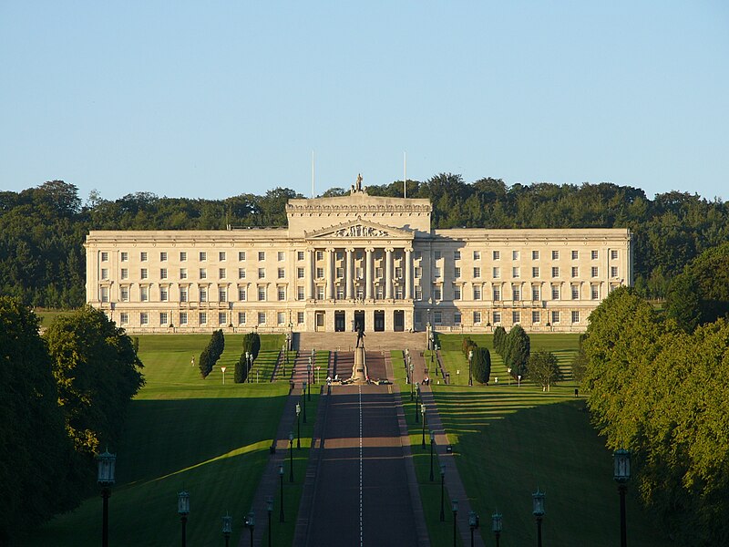
For plant lovers, the Botanic Gardens in the south part of the city occupies 28 acres with features such as a Palm House and a Tropical Ravine House.  The Gardens occasionally host concerts and festivals.  Fans of the TV series The Fall may find the Gardens familiar, as they are one of a number of Belfast locations which feature in the storyline.  The Crumlin Road Gaol is no longer used as a prison, having ceased that function in 1996, but it holds tours and events.  One of the most familiar landmarks in Belfast is the Belfast City Hall with its green copper domes, which is open to visitors and offers tours.  The city’s St Anne’s Cathedral has lent its name to the Cathedral Quarter, probably the liveliest district in the city at night, with a host of restaurants, bars, nightclubs and hotels for night owls to discover.   The imposing Parliament Buildings, commonly known as Stormont, are in the Stormont Estate to the east of the city.  The Estate also houses Stormont Castle, a hefty pile reworked in the Scottish Baronial style in the 19th century which hosts meetings of the Northern Ireland Executive.

File:StormontGeneral.jpg
Stormont. Photo by LukeM212, via Wikimedia Commons.

This is just a sample of the attractions on offer in present-day Belfast.  Needless to say a vibrant city like this has lots going on.  The Cathedral Quarter has its own Arts Festival, and also hosts events such as the Festival of Fools and Belfast Pride.  For a list of events in the city follow this link.

Map of the area


Wednesday, 1 November 2017

HELEN'S BAY


Helen’s Bay’s two main assets are its beaches and its golf course, both of them well frequented by inhabitants of nearby Belfast.  Helen’s Bay railway station is the starting point for a walk along the Clandeboye Way to Whitespots Country Park, taking in leadmines and the Somme Heritage Centre (see Newtownards post).  Commenters on the walk have described it as a “real delight” and a “lovely walk with varied scenery and terrain”, although there are complaints about a lack of waymarking.  The village itself was established as a planned village named after Helen, Lady Dufferin, with the aim of creating a luxury holiday resort linked to the Belfast and County Down Railway.

Just outside Helen’s Bay is Crawfordsburn Country Park, which forms a scenic backdrop to the beaches as well as views across Belfast Lough.  The park’s attractions include a waterfall, wildlife such as rabbits, badgers, seals and herons, and Grey Point Fort, with its guns pointing out to sea and a military museum.  The fort is relatively new, having been started in 1907 to provide Belfast with a defence against naval attacks.


File:Crawfordsburn Country Park.JPG
Crawfordsburn Country Park. Photo by Stubacca, via Wikimedia Commons.

Thursday, 26 October 2017

BANGOR


In 2013 news reports carried the revelation that the town of Bangor had been named the sexiest place in the UK.  This was based on research by the Lovehoney website into where in the country people were spending the most on spicing up their love lives.  The research uncovered the startling statistic that the good folk of Bangor were spending 6.7 times the national average on erotic products.

Bangor lies on the southern shore of the Belfast Lough, just 12 miles from the capital of Northern Ireland.  The town’s history goes back to at least 558, when Bangor Abbey was founded by St Comgall, and the town went on to become a great centre of learning.  It was in Victorian times that the town became a popular seaside resort, with Charles Dickens among the first to take to the beach there, during a lecture tour of Ireland in 1858.  In 1937 an outdoor pool named the “Pickie Pool” was built, complete with diving boards.  Sadly, unlike many such pools from the period, this one fell into disrepair and was demolished in the 1980s, to be replaced by the Pickie Fun Park. 

During the latter part of the 20th century the town suffered a number of tragedies relating to The Troubles.  There were a number of bomb attacks, including an incendiary bomb attack on the main shopping centre by paramilitaries in 1974.  In 1975 a female Royal Ulster Constabulary officer was killed while on foot patrol in the High Street, the first to be murdered on duty.  Things were still tense in the 1990s, with two bomb explosions on Main Street, one in 1992 and another a year later, the latter causing £2 million of damage and injuring four RUC officers.

Happily, things have been quieter since, and the regeneration which saw the end of the Pickie Pool also spawned the  Bangor Marina which, along with the usual facilities for leisure craft, also boasts hotels, restaurants, bars, shops and cinemas, as well as a leisure centre, golf and tennis.  The Ulster Folk and Transport Museum is nearby, while other attractions in the town include the North Down Museum, which tells the history of the area since the Bronze Age, and the Castle Park, incorporating the Bangor Castle Walled Garden, designed by the Ward family.

For a list of events in Bangor follow this link.

Live streaming webcam view from Ballyholme Yacht Club.


File:Bangor marina and harbour - geograph.org.uk - 980296.jpg
Bangor marina and harbour - geograph.org.uk - 980296. Photo by Ross, via Wikimedia Commons.