Labels

Aberdeenshire (21) Angus (4) antiquities (87) Argyll and Bute (35) Arran (7) art (37) birds (231) bridge (9) Caithness (12) Carmarthenshire (5) castle (164) Ceredigion (9) Channel Islands (13) Cheshire West and Cheshire (1) City and County of Swansea (1) City of Bristol (2) City of Edinburgh (4) Conwy (8) Cornwall (74) County Antrim (19) County Down (23) County Durham (3) County Londonderry (4) Cumbria (19) Denbighshire (2) Devon (48) diving (9) Dorset (18) Dumfries and Galloway (22) Dundee City (1) East Lothian (6) East Sussex (16) East Yorkshire (6) English Riviera (3) Essex (17) Fife (19) Flintshire (1) food (12) fossils (14) gardens (28) Ghosts (36) Glamorgan (1) Gower (7) Guernsey (4) Gwent (1) Gwynedd (19) Hampshire (13) Highland (72) Inner Hebrides (42) Inverclyde (5) Islay (8) Isle of Anglesey (14) Isle Of Man (7) Isle Of Wight (10) Isles of Scilly (3) Jersey (7) Kent (22) Lancashire (8) Lewis and Harris (7) lighthouse (62) Lincolnshire (8) Merseyside (8) Mid Glamorgan (1) mining (23) Moray (10) Mull (8) Norfolk (21) North Ayrshire (13) North Yorkshire (12) Northern Ireland (45) Northumberland (17) Orkney (10) Outer Hebrides (14) Pembrokeshire (27) pubs (50) Ross and Cromarty (20) Scotland (299) Scottish Borders (3) Shetland (14) shipwrecks (42) Skye (12) smuggling (48) Somerset (9) South Ayrshire (6) South Glamorgan (5) South Gloucestershire (2) Suffolk (18) surfing (92) Sutherland (16) Tyne and Wear (8) Wales (93) wartime (75) webcams (232) West Dunbartonshire (3) West Glamorgan (9) West Sussex (9)

Friday, 27 January 2012

PORTGORDON

The foreign accents were a bit of a giveaway, as was the fact that they were consulting a map and looking lost. Added to which, in this small Scottish fishing village, any strangers would stand out like a sore thumb. The year was 1940, the place Portgordon's railway station, where the station master's suspicions were aroused by a couple attempting to buy railway tickets for a train heading south. In fact, the couple in question were Nazi spies who, along with one other, had been brought from Nazi-occupied Stavanger in Norway and landed on the north-east coast of Scotland, where they tried to make themselves out to be German refugees. Finally, the station master's misgivings led to him slipping out to alert the local bobby, who arrested the couple. The female spy, the Serbian-born Vera Eriksen, was the only one who was spared execution, and there is speculation that the reason she was spared was because she was carrying the love child of a British VIP.

Portgordon was named after the 4th Duke of Gordon, who established the village in 1797. Fishing became the mainstay of the village's economy, and in the 1880s Frances Groome's Ordnance Gazeteer of Scotland noted that the village had 99 fishing boats employing 200 men and boys. The village was once dubbed "Paraffin City" due to its unusual form of street lighting powered by paraffin, lovingly tended by the local lamp-lighter, who would go around the village at 10 o'clock every night extinguishing all the lights. The nickname stuck even after the arrival of electricity in 1937. A campaign is underway to restore the harbour, organised by the Portgordon Community Harbour Group, who hold an annual Gala Day each summer to raise funds for the project.

Map of the area.

Portgordon - geograph.org.uk - 736144. Photo by Ann Harrison, via Wikimedia Commons.


Wednesday, 25 January 2012

BUCKIE

Buckie, which lies at the mouth of the Buckie Burn, has a long-standing fishing industry, involving both the catching of fish and processing, with the fish-processing plants based here producing such delicacies as fresh and frozen langoustine and smoked salmon. There is also a shipyard devoted to the building of and repairs to a range of craft including fishing vessels. The Buckie and District Fishing Heritage Centre shares the town's fishing tradition past and present with visitors. The harbour is named Cluny Harbour after the family which built it in 1877. A former harbour called Buckpool Harbour has been filled in and converted into a park, and it is the finishing point of the Speyside Way (or the starting point, depending on which way you choose to do it). In summer there are boat trips, some of which venture out into the Moray Firth in search of the pods of dolphins for which this stretch of water is so famous. Buckie has a number of churches, including St Peter's, whose twin spires tower over the town.

Map of the area.

Buckie Harbour - geograph.org.uk - 223399. Photo by Ann Burgess, via Wikimedia Commons.


Monday, 23 January 2012

FINDOCHTY

The houses that cluster around the harbour of this Moray fishing village are brightly painted, making it one of the most attractive villages along this stretch of coast. The earliest recorded instance of the name was in 1440, while the following century the land around the port was acquired by the Ord family, who built a castle there, now a ruin. It was also the Ords who established the fishing activity in the port. Like so many of the smaller fishing villages, this facet of the economy has now largely been given over to leisure pursuits, but a reminder of the village's past as a fishing port remains in the form of a statue of a fisherman watching over the harbour, created by a local artist. There are many caves in the coast around here, and in 1899 prehistoric bones were discovered in one of them, identified as having been fashioned into implements. Walkers can strike out along the cliff top paths towards Portknockie to the east or Buckie to the west. Caravanners who are dolphin enthusiasts are in for a treat here in Findochty, because the caravan park looks out onto a bay where the famous Moray Firth dolphins can sometimes be seen.

Map of the area.

Findochty Harbour - geograph.org.uk - 688561. Photo by Ann Harrison, via Wikimedia Commons.


Sunday, 22 January 2012

PORTKNOCKIE

Examples of artistic inspiration can be found all over the British coast, whether in the form of an artist's depiction of the scenery and local life of the area displayed in a gallery, or an unusual artistic community project. An example of the latter was unveiled in 2009 in the Moray village of Portknockie. A local artist collected handprints from residents of the village and combined them in a mosaic which was used as a piece of outdoor artwork. The mosaic depicted images representative of the village, including two fish 16 feet long, as depicted in the village's coat of arms.

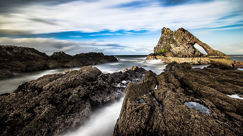
Portknockie, a fishing village in Moray just inside the border with Aberdeenshire, was founded in 1677 and during the 19th century became important for herring fishing. The harbour is overlooked by Green Castle, which was once a Pictish stronghold. The stretch of coast around Portknockie is known for its striking coastal scenery, which includes wierd and wonderful shapes and arches, the best known of which is the Bow and Fiddle which emerges from the sea just offshore. There are also a number of caves, one of which, the Preacher's Cave, was used as a church in the early 19th century. A walk along the cliff top towards Findochty provides wonderful views across the Moray Firth to the Black Isle.

Map of the area.

Bow Fiddle, Portknockie Scotland United Kingdom (103630775). Photo by Giuseppe Milo, via Wikimedia Commons.


Friday, 20 January 2012

CULLEN

There are many delights for food lovers in Scotland, but one of the most enjoyable to my mind are the lovely, warming soups which are especially welcome in the chilly climate of this northern corner of the British Isles. One of the best known Scottish soups is Cullen Skink, which tastes much better than its rather uninviting name suggests; its main ingredients are smoked haddock, potatoes and onion, smoked haddock being a regular feature in the diet on this stretch of coast. On his visit to the town, Samuel Johnson, in his usual forthright manner, declared himself to be disgusted by the sight of "dried haddock broiled", so much so that he refused to eat it for breakfast. But don't let him put you off trying this local delicacy.

Cullen is a resort built on two levels, set on the beautiful Cullen Bay. The lower part is the fishing village of Seatown, built in the typical style of a traditional Aberdeenshire fishing village, while the upper village, a former royal burgh, has a square boasting an ornate market cross dating from 1696. The two parts are separated by a disused railway, whose viaducts are used by walkers and cyclists and offer wonderful views, matched only by the views from the local Golf Club. The wife of Robert The Bruce died in the area, and her organs are thought to be buried in Cullen's Auld Kirk, which dates from at least the 14th century. Cullen Burn is believed to equate to the River Celnius, which was mentioned by Ptolemy in "Geography", written around 139-161.

Map of the area.

Seatown and Cullen Bay - geograph.org.uk - 688640. Photo by Ann Harrison, via Wikimedia Commons.


Tuesday, 17 January 2012

SANDEND AND FINDLATER CASTLE

The traditional fishing village of Sandend was established before the early 1600s, meaning it predates many of the other fishing communities around this area. It has one of Scotland's smallest harbours, backed by short streets consisting of tightly knit houses running at right-angles to the sea. Sandend Bay has a fine sandy beach perfect for walking the dog. Overlooking the bay to the east of the village is the Glenglassaugh Distillery, founded in 1875. The distillery was revived in 2008 after being mothballed in 1986, and is known for its single malt whisky. Visitors are welcome, although there is no visitor centre as yet, and they can purchase award-winning aged whiskies as well as younger drinks.

West of Sandend is the ruined Findlater Castle, which clings precariously to an outcrop of rock, so weathered that it almost looks like a natural extension of the cliff top. There have been fortifications here since at least the 13th century, although the original structure was lost during an attack by the Danes, and what you see now probably dates from the 14th century, when it was owned by the Sinclairs. The castle was passed to the Ogilvies in the 15th century, one of whose offspring, James Ogilvie, a Steward to Mary Queen of Scots, was disinherited and the castle passed to Sir John Gordon. However, James was having none of this and set out to regain the land from the new incumbent. Mary Queen of Scots sent troops to seize the castle, and to cut a long story short, a series of battles ensued culminating in Gordon's beheading, upon which the castle was returned to the Ogilvies, but not for long because they moved to Cullen around 1600.

Map of the area.

Findlater Castle Scotland. Photo by Ingo Wölbern, via Wikimedia Commons.


Sunday, 15 January 2012

PORTSOY

Anyone who loves traditional boats should head to Portsoy for the Scottish Traditional Boat Festival which takes place in late June. Traditional boats from far and wide congregate on the harbour here, while the festival itself showcases traditional crafts such as boat building, knitting, music and art. Hungry visitors also have a food fayre to whet their appetites.

Portsoy, established as a Burgh by Mary Queen of Scots, was one of the earliest ports to be established along the Moray and Aberdeenshire coasts. Portsoy has the oldest harbour on the Moray Firth, and its 17th century warehouses remain as a reminder of past glory. One of the warehouses acts as a workshop for a decorative stone known as Portsoy Marble, a variety of serpentine whose uses included parts of the Palace of Versailles. The Salmon Bothy is a former Salmon House which has been converted into a museum. The coastal path heading out of Portsoy offers views of fascinating rock formations as well as the chance to see the dolphins for which the Moray Firth is so well known.

Map of the area.

PORTSOY HARBOUR. Photo by Michael Garlick, via Wikimedia Commons.