Labels

Aberdeenshire (21) Angus (4) antiquities (87) Argyll and Bute (35) Arran (7) art (37) birds (231) bridge (9) Caithness (12) Carmarthenshire (5) castle (164) Ceredigion (9) Channel Islands (13) Cheshire West and Cheshire (1) City and County of Swansea (1) City of Bristol (2) City of Edinburgh (4) Conwy (8) Cornwall (74) County Antrim (19) County Down (23) County Durham (3) County Londonderry (4) Cumbria (19) Denbighshire (2) Devon (48) diving (9) Dorset (18) Dumfries and Galloway (22) Dundee City (1) East Lothian (6) East Sussex (16) East Yorkshire (6) English Riviera (3) Essex (17) Fife (19) Flintshire (1) food (12) fossils (14) gardens (28) Ghosts (36) Glamorgan (1) Gower (7) Guernsey (4) Gwent (1) Gwynedd (19) Hampshire (13) Highland (72) Inner Hebrides (42) Inverclyde (5) Islay (8) Isle of Anglesey (14) Isle Of Man (7) Isle Of Wight (10) Isles of Scilly (3) Jersey (7) Kent (22) Lancashire (8) Lewis and Harris (7) lighthouse (62) Lincolnshire (8) Merseyside (8) Mid Glamorgan (1) mining (23) Moray (10) Mull (8) Norfolk (21) North Ayrshire (13) North Yorkshire (12) Northern Ireland (45) Northumberland (17) Orkney (10) Outer Hebrides (14) Pembrokeshire (27) pubs (50) Ross and Cromarty (20) Scotland (299) Scottish Borders (3) Shetland (14) shipwrecks (42) Skye (12) smuggling (48) Somerset (9) South Ayrshire (6) South Glamorgan (5) South Gloucestershire (2) Suffolk (18) surfing (92) Sutherland (16) Tyne and Wear (8) Wales (93) wartime (75) webcams (232) West Dunbartonshire (3) West Glamorgan (9) West Sussex (9)

Monday, 4 June 2018

CULMORE


Culmore is at the mouth of the River Foyle, a short distance downstream from the city of Londonderry, or Derry, slightly further inland.  This geographical location proved to be of strategic importance in May 1600 when Sir Henry Docwra, 1st Baron Docwra of Culmore, landed here with his army prior to taking Derry in an attempt to quash a war against the crown in Ulster.  The 17th century Fort Culmore on Culmore Point played a part in another event a few years later when Sir Cahir O’Doherty captured a supply of arms from there before launching what came to be known as O’Doherty’s Rebellion.  A more recent claim to fame for the village is that Amelia Earhart completed her solo translatlantic flight in 1932 by coming down on Culmore. 


Just beyond Culmore is the border with the Republic of Ireland, making it the last mainland coastal settlement on my blogging odyssey around the British coast.  However, there is one last place to blog about: Rathlin Island.  Watch this space.
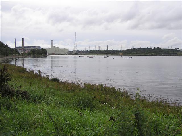

File:Culmore point - geograph.org.uk - 953319.jpg
Culmore Point - geograph.org.uk - 953319. Photo by Kenneth Allen, via Wikimedia Commons.


Thursday, 24 May 2018

MAGILLIGAN POINT


Well, I am nearing the end of my blogging journey around the British coast, and this is the last headland before the border with the Republic of Ireland.  Poking out into the mouth of Lough Foyle, Magilligan Point is a short distance from the Republic and there is a year-round ferry to Greencastle on the other side.  A short distance from the ferry crossing point is a Martello tower built during the Napoleonic Wars to protect the lough from those pesky French, but also as a defence against American privateers.  Group tours of the tower can be undertaken by arrangement.  The tower stands within the Magilligan Point Nature Reserve, distinguished by its extensive system of sand dunes, the largest in Northern Ireland.  The flora growing among the dunes attract a variety of insects such as bees and moths, including the rare Scarce Crimson and Gold Moth, a variety of moth only found along this coast.


File:Martello Tower, Magilligan Point - geograph.org.uk - 583940.jpg
Martello Tower, Magilligan Point - geograph.org.uk - 583940. Photo by Ross, via Wikimedia Commons.


Friday, 18 May 2018

CASTLEROCK


The kilometre-long stretch of sandy beach stretching to the west of the mouth of the River Bann belongs to the small resort of Castlerock.  The beach is adjacent to the Castlerock Golf Club and its dunes continue upstream to a National Trust bird sanctuary.  Wildlife enthusiasts should keep their eyes peeled when eyeing the estuary as harbour porpoises and seals can sometimes be seen feeding there.  Castlerock’s celebrity claim to fame is that the actor James Nesbitt called the resort home when a teenager. 


Another famous name associated with Castlerock is the author C. S. Lewis, who used to holiday there when growing up in Belfast.  Lewis used to visit the nearby Downhill Demesne, and was so captivated by the site that it provided inspiration for some of his work, including The Lion, the Witch and the Wardrobe.  The Demesne is run by the National Trust and includes the ruined 18th century mansion Downhill House, a Mausoleum, a Dovecote and an Icehouse among its points of interest.  For nature lovers there are The Bog Garden, The Black Glen, and there is a Walled Garden which nowadays is home to sheep and apple trees.  Another attraction within the Demesne is the clifftop Mussenden Temple, which is based on the Temple of Vesta in Italy, and which, along with the beautiful beach it overlooks, featured in Game of Thrones as Dragonstone.  By the way, the word 'demesne' is used in Ireland to mean a piece of land attached to a manor.


File:Mussenden Temple overlooking Downhill beach. Northern Ireland.jpg
Mussenden Temple overlooking Downhill beach. Northern Ireland. Photo by D LN, via Wikimedia Commons.


Thursday, 10 May 2018

PORTSTEWART


In a dramatic scene from series 5 of Game of Thrones, Jaime Lannister and Bronn are seen duelling with the Dornish guards on a stunning beach.  The beach in question was the Strand of Portstewart, just across the county border from Portrush, in County Londonderry.  The timing of the filming, which took place in 2014, was unfortunate, being in August, the busiest time of the year, as the beach had to be completely closed for it.  However, there was significant payback for the resort, which gained valuable exposure as a result of its starring role in the series.


The Portstewart Strand, which holds Blue Flag status, stretches out from the mouth of the River Bann, with the Portstewart Golf Club at one end.  The beach is popular with surfers, and in the town there is a Dive Centre for divers at Aquaholics, where boat trips can also be booked.  On the opposite bank of the river and inland a bit is a bird hide run by the National Trust (as is the Strand itself).  The hide offers the opportunity to observe waterfowl, waders and nesting birds.  The built up part of Portstewart lies to the other side of the golf course, occupying an area surrounding a small rocky peninsula, and it has a range of cafes, restaurants, pubs and shops for visitors to choose from.  There is a promenade leading to the Strand, taking in a small harbour. 


File:The Promenade at Portstewart - geograph.org.uk - 1322701.jpg
The Promenade at Portstewart - geograph.org.uk - 1322701. Photo by Des Colhoun, via Wikimedia Commons.


Thursday, 3 May 2018

PORTRUSH


Portrush, which has signs of human habitation going back to around 4000 BC, started out as a fishing town, but the arrival of the Ballymena, Ballymoney, Coleraine and Portrush Junction Railway in 1855 paved the way for its development into a resort.  


The big attractions at Portrush are its wonderful beaches, the windswept location making them popular with surfers.  Horse riders and dog walkers are also attracted to the golden sands, though these should be aware that restrictions apply from May to September.  Whiterocks Beach, so named because of the limestone cliffs and rocks dotted about the beach, which were formed around 150 million years ago during the Cretaceous Period, lies to the east of the town, bordered by the Royal Portrush Golf Course.  The East Strand, meanwhile, is managed by the National Trust, so parking is free for members.  


For offshore activities, the town has a Yacht Club.  The town itself is built on a peninsula called Ramore Head (the name Portrush comes from the Irish Port Rois, meaning “promontory port”.  On the east side of the peninsula is the Blue Pool, which is popular with divers.  Golfers are well catered for, with a second golf course, Ballyreagh Golf Course, to the west of the town.  The Coastal Zone is a visitor centre with an exhibition space covering aspects of the area’s history and natural attributes.  A group of small offshore islands called The Skerries are home to seabirds such as kittiwake and eider duck as well as more exotic marine species such as the cotton spinner sea cucumber.


Portrush  hosts a number of prominent events every year, including an Air Show in September, the North West 200 motorcycle race in May and an RNLI Raft Race.  

Webcam view of Whiterocks Beach.


File:The White Rocks near Portrush (3) - geograph.org.uk - 785946.jpg
The White Rocks near Portrush (3) - geograph.org.uk - 785946. Photo by Albert Bridge, via Wikimedia Commons.

Thursday, 19 April 2018

DUNLUCE CASTLE


Such is the appeal of the now-ruined Dunluce Castle that it, and its magnificent surroundings, have been the inspiration for both poetry and music.  The 4-part poem published in 1814 by Edward Quillinan sets the scene at length, describing the castle itself, the roar of the Atlantic “in wildest fury frantic” and the dramatic coastline around it.  A tone poem called Dunluce was written in 1921 by Irish composer Norman Hay, while a more recent musical work called Dunluce Castle was performed by the Irish Rovers in the 1990s.  The castle made an appearance on the sleeves of two albums: Led Zeppelin’s Houses of the Holy in 1973 and American musician Jandek’s Glasgow Friday in 2008.  The castle is believed to have been the inspiration for Cair Paravel in Chronicles of Narnia by C. S. Lewis.  Finally, not surprisingly, the castle was one of the many Northern Irish locations used in Game of Thrones as the castle of Pyke, seat of House Greyjoy.


Dunluce Castle was the first stop on our wonderful drive along the Causeway Coast a few years ago, and it set the scene magnificently for the rest of it.  The castle was built by the MacQuillan family around the year 1500, but 50 years later it was seized by the MacDonnell clan.  There was once a small town called Dunluce, founded by the Earls of Antrim in the 17th century.  The town was abandoned long ago, but visitors can view the remains uncovered by an archaeological dig.  The castle’s precarious position perched over the foaming sea was allegedly the cause of a catastrophe in 1639, when the castle’s kitchen fell into the sea along with the unfortunate kitchen staff while the 2nd Earl of Antrim and his wife were waiting for their dinner.  However, the veracity of this story is in some doubt, since the kitchen is still in situ among the present-day ruins.  What is for sure is that in the 18th century the north wall of the residence building did fall into the sea.  The remaining walls are still standing. 


File:Awesome Dunluce Castle.jpg
Awesome Dunluce Castle. Photo by Osioni, via Wikimedia Commons.


Thursday, 5 April 2018

PORTBALLINTRAE


Looking at Portballintrae on the map, the eye is drawn to a small but perfectly formed horseshoe-shaped bay.  At one end of this is a small harbour, formerly the haunt of the local fishermen, but nowadays used mostly by leisure craft, and at the eastern end is Salmon Rock Beach which, while popular with families, is risky for swimmers.  The Bush River wends its way down to the coast to the northeast of the village, enclosing the Bushfoot Golf Course.  Back in 2007 it was reported that Donald Trump was considering the village as the site of a £1 billion golf complex, but it never came to pass. 


On the outskirts of the village are two strange mounds of earth forming concentric rings.  Known as the Lissanduff Earthworks, it is not clear what their original purpose might have been.  Some archaeologists, however, think they may have been linked to ancient worship rituals.  Fast forwarding to the 16th century, in 1588 a Spanish galleass called the Girona, part of the Spanish Armada, sank off Lacada Point, further back along the coast from Portballintrae.  In the 1960s a treasure trove from the ship was recovered by a team of Belgian divers, and was hauled ashore at Portballintrae.  It was the greatest find ever recovered from a Spanish Armada vessel and the gold jewellery from the hoard is displayed in the Ulster Museum in Belfast.


File:The bay of Port Ballintrae. - geograph.org.uk - 435121.jpg
The bay of Portballintrae. - geograph.org.uk - 435121. Photo by Des Colhoun, via Wikimedia Commons.