Labels

Aberdeenshire (21) Angus (4) antiquities (87) Argyll and Bute (35) Arran (7) art (37) birds (231) bridge (9) Caithness (12) Carmarthenshire (5) castle (165) Ceredigion (9) Channel Islands (13) Cheshire West and Cheshire (1) City and County of Swansea (1) City of Bristol (2) City of Edinburgh (4) Conwy (8) Cornwall (74) County Antrim (19) County Down (23) County Durham (3) County Londonderry (4) Cumbria (19) Denbighshire (2) Devon (48) diving (9) Dorset (18) Dumfries and Galloway (22) Dundee City (2) East Lothian (6) East Sussex (16) East Yorkshire (6) English Riviera (3) Essex (17) Fife (19) Flintshire (1) food (13) fossils (14) gardens (28) Ghosts (35) Glamorgan (1) Gower (7) Guernsey (4) Gwent (1) Gwynedd (19) Hampshire (13) Highland (72) Inner Hebrides (42) Inverclyde (5) Islay (8) Isle of Anglesey (14) Isle Of Man (7) Isle Of Wight (10) Isles of Scilly (3) Jersey (7) Kent (22) Lancashire (8) Lewis and Harris (7) lighthouse (62) Lincolnshire (8) Merseyside (8) Mid Glamorgan (1) mining (23) Moray (10) Mull (8) Norfolk (21) North Ayrshire (13) North Yorkshire (12) Northern Ireland (45) Northumberland (17) Orkney (10) Outer Hebrides (14) Pembrokeshire (27) pubs (47) Ross and Cromarty (20) Scotland (300) Scottish Borders (3) Shetland (14) shipwrecks (42) Skye (12) smuggling (48) Somerset (9) South Ayrshire (6) South Glamorgan (5) South Gloucestershire (1) Suffolk (18) surfing (84) Sutherland (16) Tyne and Wear (8) Wales (93) wartime (75) webcams (232) West Dunbartonshire (3) West Glamorgan (9) West Sussex (9)

Thursday, 30 January 2014

PENMAENMAWR


Hemmed in by the mighty Penmaenmawr headland at one end and the smaller Penmaenbach at the other end, the quiet seaside town of Penmaenmawr became a resort in the 19th century when well-to-do tourists started visiting, perhaps encouraged by the praise lavished on the resort by the 19th century British Prime Minister William Ewart Gladstone, who visited no less than 11 times and who affectionately referred to the town as "dear old Penmaenmawr".  There is a memorial to the politician which was made in 1991 to replace an earlier one which was stolen in the 1970s.  The Penmaenmawr headland, in reality a mountain reaching directly down to the sea, is 1,300 feet high, while Penmaenbach marks the northern end of the Snowdonia range.  The summit of Penmaenmawr has been quarried away, a reminder of the time when quarrying was big business here.  There was a hill-fort on the top called Braich-y-Dinas, one of the largest  hill-forts in Europe, but barely any trace of it remains now.  Prehistoric remains have been found on the mountain, including signs of the manufacture of stone axes which are believed to have been exported as far afield as Cornwall and South East England.  Also on Penmaenmawr is the Druid's Circle, or Meini Hirion, consisting of some 30 standing stones, regarded as one of the best such sites in Wales.

When the railway arrived in the area tunnels had to be built through the mountains.  The main A5 road which follows roughly the same route used to follow a precarious route around the mountains but as the number of cars increased further tunnels were constructed to accommodate the road traffic.  Just off the coast of Penmaenmawr is a rocky formation called Llys Helig which is believed to have been used by fishermen as far back as the 6th century.  Legend has it that there is a sunken kingdom under this spot.  The gently sloping beach is separated from the village by the railway line and has a promenade running along it with views taking in Anglesey, Puffin Island and the Great Orme, as well as breathtaking sunsets.  Activities on offer besides lounging around on the beach include bowling, golf and a Sailing Club.  For keen cyclists, there is a cycle path from Conwy to Llanfairfechan which passes through here, and walkers can enjoy wonderful mountain and coastal walks.  The Penmaenmawr Historical Society and Museum has a collection of local objects and archive photographs.  

Map of the area.
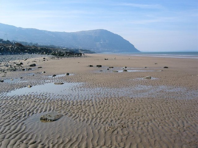
File:Penmaenmawr Sands - geograph.org.uk - 68820.jpg
Penmaenmawr Sands - geograph.org.uk - 68820. Photo by David Crocker, via Wikimedia Commons.

Monday, 27 January 2014

CONWY


The spot occupied by the fortified town of Conwy on the Conwy Estuary is dominated by its magnificent castle, erected by Edward I as part of his 'iron ring' intended to quell the Welsh uprisings against the invading English.  Owain Glyndwr, the hero of the Welsh resistance, managed to capture the castle in the early 15th century, but not for long.  He was forced back into the mountains and pursued to Harlech.  During the English Civil War the castle was beseiged by the parliamentary army for over 3 months.  They then destroyed parts of it to prevent reoccupation by the Royalists.  The castle's features include two fortified gateways, or barbicans, eight towers, a great hall and a chapel.  Unlike other castles built around that time, there are no 'walls within walls' because its position on a rocky outcrop provided enough security for that feature to be deemed unnecessary.  The castle has justifiably been granted World Heritage Site status, and visitors can enjoy breathtaking views of the mountains and the sea.  As well as its castle, Conwy's fortifications are complemented by over three-quarters of a mile of walls with 22 towers. 

At the other end of the size spectrum, there is a house on the quayside which is claimed to be the smallest house in Great Britain.  Quay House was first occupied in the 16th century, and the last inhabitant to occupy the house before it became a tourist attraction was a fisherman over 6 feet tall, which must have made for an interesting existence.  Now visitors to the house are greeted by a lady in traditional Welsh costume and for a small entrance fee can enter the house - no more than four at a time though, which is all the  house can take.  Inside, the tiny beamed rooms contain old photographs and period household objects.  Back in the town centre, Aberconwy House, a medieval merchant's house owned by the National Trust, is also open to visitors.  St Mary's Church has the remnants of a former abbey built by the Maenan Monks.  The monks were relocated by Edward I to a location near Llanwrst in the Conwy valley.  On the east side of the estuary is RSPB Conwy, where at this time of year there are ducks and waders visiting from Siberia and the amazing sight of 'murmurating' starlings.

Map of the area.

File:Conwy 1.jpg
Conwy 1. Photo by Donatella Tronca, via Wikimedia Commons.

Wednesday, 22 January 2014

DEGANWY


High up above the village of Deganwy is a massive outcrop of rock called Vardre Hill with the remains of fortifications which go back to Roman times.  Deganwy Castle's position by the River Conwy was considered to be of major strategic importance in the post-Roman era, so much so that over the years it changed hands between Normans, English and Welsh, with much alternate destruction and rebuilding.  During the 13th century, when the Welsh held sway over the castle, the threat of the relentless advance by the English led to the castle being destroyed so effectively that when the English came in 1245 they were reduced to sleeping in tents.  The ruins seen today are all that remains of the castle as it was during the time of Henry III.  Henry's son Edward took a fancy to Conwy as an alternative site, since it occupied a strategic location at the frontier of Gwynedd, and Deganwy Castle was finally abandoned and demolished in 1263 by the Prince of Wales Llywelyn ap Gruffudd.  Those feeling energetic enough to climb up to the ruins will be rewarded by a lovely view of Conwy Castle as well as views of Llandudno and a large swathe of the surrounding coast.

Deganwy is a village on the opposite shore of the of the River Conwy from the town of Conwy.  The Quay was originally built for the purpose of exporting slate which had been quarried in the mountains of nearby Snowdonia, and there was a railway line linking it to Blaenau Ffestiniog from where the slate was transported.  Nowadays the quay is devoted to more leisurely pursuits, with a 165-berth marina and a luxury hotel and spa, all of which is enhanced by wonderful views of Conwy Castle and the mountains.   Each summer the village holds a Prom Day and on the previous day the Deganwy Dash, a 5-mile coastal run, takes place.

Map of the area.

File:Deganwy from Conwy Castle - geograph.org.uk - 1480431.jpg
Deganwy from Conwy Castle - geograph.org.uk - 1480431. Photo by Nigel Chadwick, via Wikimedia Commons.

Sunday, 19 January 2014

LLANDUDNO


Everyone has a particular childhood holiday which stands out in their memory, and for me it is the holiday I spent with my parents in Llandudno when I was a teenager.  The main reason Llandudno made such an impression on me is that, growing up in the merely hilly Cornwall, I had never seen a mountain before, and Llandudno has magnificent views towards the outer reaches of Snowdonia, as well as an impressive peak of its own: the Great Orme, which looks across at its kid brother the Little Orme, with the graceful curved sweep of the resort’s seafront separating the two.  There can be few coastal experiences in Britain more exhilarating than standing on top of the Great Orme on a sunny day with the deep blue sea stretching out in all directions (only marred by the sight of the dreaded wind turbines out at sea).  

View from the Great Orme


Another young girl who enjoyed family holidays in Llandudno was one Alice Liddell.  Her father was the Dean of Christ Church, Oxford, and one of his colleagues was the writer Lewis Carroll.  Carroll was a close friend of the family, and was very fond of Alice, who was the inspiration for Alice in Wonderland and Alice Through the Looking Glass.  The Liddell family used to spend their holidays in a large house on Llandudno's West Shore, and in 1933 a statue of the White Rabbit from Alice in Wonderland was unveiled on the West Shore.  Unfortunately, as a sad sign of the times the statue was vandalised in 2012 and removed for restoration.  However, determined not to be defeated in its quest to make the most of its Alice connections, the town has created an "Alice trail" marked by wooden figures of characters from the stories.   

The resort of Llandudno was developed in the 1850s by the Mostyn family, and straddles a piece of land in the shadow of the Great Orme.  There are two "shores", the North Shore, where most of the attractions are to be found, and the quieter West Shore which is known for its wonderful sunsets.  The resort retains its Victorian character to this day, with its two-mile promenade, its 700m long pier and the shops with their elegant cast iron and glass colonnades.  The Professor Codman Show near the entrance to the pier is believed to be the oldest Punch and Judy in existence, and is a must both for present-day children and for adults wanting to relive their childhoods.  The Llandudno Museum has photographs and exhibits on local history, while the Oriel Mostyn gallery has regular exhibitions.  

Looking towards the Great Orme
As for the Great Orme itself, the most popular way of getting to the top is via the vintage Tramway dating from 1902 which trundles up the mountain in two stages, sending sheep scattering as it goes.  At the Halfway Station there is a fascinating exhibition on the history of the Tramway.  For those with a head for heights, an alternative way of ascending the mountain is to take to the the Great Orme Aerial Cable Cars.  If you prefer to stay car-bound you can take the scenic 4-mile Marine Drive around the base of the mountain.  For the particularly energetic, it is possible to ascend on foot.  It is well worth the effort of getting up there because the views from the top are magnificent.  On a clear day it is possible to see as far as the Isle of Man, 57 miles away.  There are refreshments available on top, a copper mine dating from the Bronze Age which is open to the public and a medieval church dedicated to St Tudno, from whom the town gets its name: Llan (holy enclosure) of Tudno.

View from Great Orme looking east


Church of St Tudno
For a list of events in Llandudno and surrounding area, see here.

Live streaming webcam view from the West Shore Beach Cafe.

Map of the area.


Tuesday, 14 January 2014

PENRHYN BAY


The quiet resort of Penrhyn Bay sits in the shadow of Little Orme, whose more famous big brother, Great Orme, towers above the adjoining resort of Llandudno.  The shingle beach with its rock pools is lined by sea defences consisting of large boulders.  The bay  started out as a farming community, then in the 19th century limestone quarrying commenced on Little Orme and a narrow gauge railway was built to service the quarry.  The quarrying ceased in 1936, leaving Penrhyn Bay to more pleasurable pursuits, and enabling the creation of a Site of Special Scientific Interest and sanctuary for sea birds.  Energetic visitors can make the climb up to Little Ormes Head from where there are wonderful views. 

The oldest building in the resort is Penrhyn Old Hall, now a restaurant and venue for events.  The hall is said to date back to the 8th century originally, when the last King of the Britons built a palace here.  The Romans are also thought to have passed through, judging by the Roman coins which have been found there.  The house belonged to a powerful Roman Catholic family, the Pughs, in Elizabethan times, and it was the scene of much drama arising from the struggle between the Catholics and Protestants, with some of the Roman Catholics conspiring to put to death the Protestants in the area.  Some of the conspirators went into hiding in a cave on the Little Orme, where they allegedly used a printing press to produce the first book printed in Wales.  The Old Hall is said to be haunted by a number of ghosts, including a monk, a young girl haunting the stairway, a soldier and an old lady.  


File:Bae Penrhyn - geograph.org.uk - 95911.jpg
Bae Penrhyn - geograph.org.uk - 95911. Photo by Dot Potter, via Wikimedia Commons.

Saturday, 11 January 2014

COLWYN BAY


Colwyn Bay lies between Rhyl and Llandudno, and consists of the communities of Old Colwyn, Colwyn Bay and Rhos-on-Sea, separated by a 3-mile stretch of sandy beach backed by a promenade, the residential parts of town rising up into the pleasant green hills behind.  There is a range of watersports available in the bay, including windsurfing, power boating and sailing.  Eirias Park offers a variety of leisure activities within its 50 acres of beautiful parkland, such as swimming, fitness and other sporting facilities.  One of the bay's premier attractions is the Welsh Mountain Zoo, on a hillside overlooking the bay.  In a corner of Old Colwyn is a nature trail called the Fairy Glen, so named by the Victorians who used to flock to the resort and who were very fond of such 'glens'.  The North Wales Path runs through the glen, which has recently had improvements carried out to it.  The name derives from the fact that the glen is rumoured to harbour many spirits including fairies.

Rhos-on-Sea lies at the far end of the promenade running along the bay.  There are several points of historical interest here, most notably a cute little chapel on the foreshore called St Trillo's Chapel, which in its present form dates from the 17th century.  Until recently this was claimed to be the smallest chapel in the United Kingdom, but last year it was reported that an upstart in Wiltshire was challenging the title.  Either way, the chapel at Rhos is undeniably minute, with room for a mere 6 to 9 people.  Out at sea is another relic from the past.  At low tide it is possible to discern the remains of a fish trap created by the monks of an ancient monastery.  The Rhos Fynach Fishing Weir dates from medieval times but did not cease to be used until World War I.  However, perhaps the greatest claim to fame by Rhos-on-Sea is that the Welsh prince Madog ap Owain Gwynedd sailed from here in 1170 and discovered America, beating Christopher Columbus by over 300 years.  

Map of the area.  

File:The Green Bank above Marine Parade, Rhos on Sea - geograph.org.uk - 453977.jpg
The Green Bank above Marine Parade, Rhos on Sea - geograph.org.uk - 453977. Photo by R. Greenhalgh, via Wikimedia Commons.

Wednesday, 8 January 2014

TOWYN AND ABERGELE


The last few weeks have seen some dreadful scenes on the British coast with the combination of high spring tides and stormy weather leaving a trail of devastation in its wake.  Faced with all this, the people of Towyn - or Tywyn in Welsh - must have been holding their breath and harbouring terrible feelings of deja vu, since this little resort on the North Wales coast has seen it all before.  On February 26 1990 the sea wall in Towyn was breached by massive waves, causing a large residential area to be inundated with seawater up to 6 feet in depth, invading houses, businesses and caravans.  Up to 6,000 people had to be evacuated, the largest such evacuation since World War II.  The coastal defences which proved unequal to the 1990 event have since been reinforced, and thankfully seem to have held up in the recent flooding episode, although neighbouring Kinmel Bay and Rhyl were sadly hit by flooding last week. 

Towyn is a small family-friendly seaside resort, while Abergele lies slightly inland, apart from the beach suburb of Pensarn, where there have been reported sightings of a ghost ship.  The main point of historical interest in Abergele is Gwrych Castle and Gardens, which lies just to the west of the town and can be clearly seen from the A55 road.  Although it looks older, the castle was constructed between 1819 and 1825.  The castle was used to house Jewish refugees during World War II, then later it opened its doors to visitors, with attractions in the grounds which included a miniature railway and a small zoo.  There were also holiday apartments available for rent.  Sadly, this all ended in 1985 when the castle was closed to the public and went into a decline.  Now the castle is up and running again, and is open to visitors daily.  A visit there could prove to be an eventful one, because the castle is one of the most haunted properties in Wales.  The castle is full of tales of apparitions, cowering, terrified dogs, the sound of galloping horses' hooves, strange smells and cold spots. 

Map of the area. 

File:Gwrych Castle.jpg
Gwrych Castle. Photo by Dot Potter, via Wikimedia Commons.

Monday, 6 January 2014

RHYL


For those who enjoy watching archive footage there is an extensive clip on the British Pathe website of a piece called 'Rhyl Holiday Story' made in 1947.  The reporter is shown mingling with the crowds strolling along the Promenade attempting to collar members of the public without much success.  The film has all the traditional trappings of the British seaside holiday: Punch and Judy, a fortune teller, people boarding a pleasure steamer.  By the time of the making of this film, Rhyl had been a popular resort for over 100 years.  Already in the 1830s it was a fashionable watering place frequented by the titled classes.  The arrival of the railway a few years later provided a further boost.  Sadly, the resort had gone into a decline by the 1990s, but there is a regeneration project which is attempting to reverse this. 

Nowadays Rhyl is marketed as the more vibrant half of the Rhyl and Prestatyn duo of resorts.  The attractions on offer are very much with the family in mind, including the SeaQuarium with its sharks, rays and conger eels, the Sun Centre indoor tropical water park and the Drift Park with a variety of activities.  The Rhyl Miniature Railway, with vintage steam engines hauling passengers around the Marine Lake, celebrated its 100th birthday in 2011.  The Pavilion Theatre hosts shows with some big names such as Nigel Kennedy and Chris Packham.  The resort used to have a funfair called the Ocean Beach Funfair, but his has now gone and is being replaced by the Ocean Plaza development with shopping, restaurants and accommodation.

For a list of events in Rhyl and Prestatyn, follow this link.

Map of the area. 

File:The sea front at Rhyl - geograph.org.uk - 1571576.jpg
The sea front at Rhyl - geograph.org.uk - 1571576. Photo by Eirian Evans, via Wikimedia Commons.

Saturday, 4 January 2014

PRESTATYN


Prestatyn is the first proper 'resort' moving along the North Wales coast from the border.  Prestatyn's origins stretch back to prehistoric times, and the Romans also set up home here.  Prestatyn lay on a route linking Chester and Caernarfon, and a fort is believed to have been built here, although the only trace of this now are the ruins of a Roman bathhouse on the outskirts of the town.  The town became popular as a resort after the arrival of the railway, and by the end of the 1930s a holiday camp had been established there.  This was commandeered during the war for use as a billet for servicemen, who also stayed in the houses of many of the locals. 

Prestatyn's popularity has no doubt been helped along by the extensive trio of sandy beaches with their dunes on either side of the town: Ffrith Beach, Central Beach and Barkby Beach.  Barkby Beach is home to the Prestatyn Sailing Club, so swimmers need to be aware of the boats using the slipway.  Ffrith Beach offers family fun at the Ffrith Beach Festival Gardens.  The 4-mile promenade joining the three beaches has been incorporated into the National Cycle Network.  Views from the promenade take in an impressive vista from Snowdonia in the west to the Wirral in the east, and on clear days the Isle of Man and the mountains of Cumbria can be made out on the horizon.  Prestatyn is the northern terminus of the magnificent Offa's Dyke Path, a long-distance trail which roughly follows the border between England and Wales, finishing up in Chepstow.  The recently completed Wales Coast Path also passes through here, so walkers are spoilt for choice.  Other popular activities include pitch and putt at Barkby Beach, while for more serious golfers there is the Prestatyn Championship Golf Course.  The Nova Centre offers swimming, and there is 10-pin bowling and indoor bowls, and the Prestatyn Circuit for car racing enthusiasts.

The big event of the year is the Prestatyn Carnival, held in July. For a list of other events in Prestatyn and neighbouring Rhyl follow this link.

Map of the area.

File:On the Offa's Dyke Path near Prestatyn Hillside - geograph.org.uk - 541328.jpg
On the Offa's Dyke Path near Prestatyn Hillside - geograph.org.uk - 541328. Photo by Mike Harris, via Wikimedia Commons.

Wednesday, 1 January 2014

FLINT


After nearly three years of blogging around the coast, I have finally reached one of my favourite parts of the British Isles: Wales.  One of the things Wales, and particularly the Welsh coast,  is best known for is its castles.  Many of these were built by Edward I with the intention of forming an "iron ring" , and the first of such castles to be built was Flint Castle.  The 13th century castle was immortalised by Shakespeare in his play Richard II which recalls an incident in 1399 when Richard II was handed over to his enemy Henry Bolingbroke.  The castle's strategic position just inside the border with England has led to many dramas over the years such as an attempted, but unsuccessful, assault by Owain Glyndwr in 1400 at the start of his revolt against the English.  The castle is now in ruins following its destruction by Parliamentarian forces, but it is looked after by the Welsh heritage organisation Cadw and can be visited all year except Christmas and New Year.  In the 1830s the artist William Turner produced a magnificent painting of the castle with the sun on the horizon in the background.  In 2010 the painting was sold for a cool £541,250.

In 1284, the year the building of the castle was completed, Flint - or Fflint to the Welsh -  was granted its town charter, making it the first place in Wales to receive one, and earning it the status of Free Borough.  During Edward I's reign the Great County Court was held four times a year in Flint.  The present Town Hall, which replaced an earlier one, is a striking Tudor-Gothic construction built from sandstone, and the main council chamber houses a copy of the 1284 charter.  

Map of the area.

File:Flint Castle - geograph.org.uk - 641269.jpg
Flint Castle - geograph.org.uk - 641269. Photo by BrianP, via Wikimedia Commons.