Labels

Aberdeenshire (21) Angus (4) antiquities (87) Argyll and Bute (35) Arran (7) art (37) birds (231) bridge (9) Caithness (12) Carmarthenshire (5) castle (165) Ceredigion (9) Channel Islands (13) Cheshire West and Cheshire (1) City and County of Swansea (1) City of Bristol (2) City of Edinburgh (4) Conwy (8) Cornwall (74) County Antrim (19) County Down (23) County Durham (3) County Londonderry (4) Cumbria (19) Denbighshire (2) Devon (48) diving (9) Dorset (18) Dumfries and Galloway (22) Dundee City (2) East Lothian (6) East Sussex (16) East Yorkshire (6) English Riviera (3) Essex (17) Fife (19) Flintshire (1) food (13) fossils (14) gardens (28) Ghosts (35) Glamorgan (1) Gower (7) Guernsey (4) Gwent (1) Gwynedd (19) Hampshire (13) Highland (72) Inner Hebrides (42) Inverclyde (5) Islay (8) Isle of Anglesey (14) Isle Of Man (7) Isle Of Wight (10) Isles of Scilly (3) Jersey (7) Kent (22) Lancashire (8) Lewis and Harris (7) lighthouse (62) Lincolnshire (8) Merseyside (8) Mid Glamorgan (1) mining (23) Moray (10) Mull (8) Norfolk (21) North Ayrshire (13) North Yorkshire (12) Northern Ireland (45) Northumberland (17) Orkney (10) Outer Hebrides (14) Pembrokeshire (27) pubs (47) Ross and Cromarty (20) Scotland (300) Scottish Borders (3) Shetland (14) shipwrecks (42) Skye (12) smuggling (48) Somerset (9) South Ayrshire (6) South Glamorgan (5) South Gloucestershire (1) Suffolk (18) surfing (84) Sutherland (16) Tyne and Wear (8) Wales (93) wartime (75) webcams (232) West Dunbartonshire (3) West Glamorgan (9) West Sussex (9)

Monday, 31 March 2014

CLYNNOG FAWR


I remember the first time I clapped eyes on the Llyn Peninsula from a distance, there was something about its romantic, mountainous shape shimmering on the horizon that made me want to go there.  When I finally did go a few years later it didn't disappoint, and it now occupies a place on my list of favourite parts of the British coast.  Clynnog Fawr is at the north-east end of the peninsula, and its main draw is one of  the best known churches in Wales.  Founded by St Beuno in the 7th century with the present building dating from the 16th century, the church was visited by pilgrims as they made their way to Bardsey Island just off the far end of the peninsula.  Local farmers used to make a split in the ears of their lambs or calves, a feature known as 'Beuno's Mark', and they paid money to the church.  The wooden trunk that held the money is still inside the church and is known as 'St Beuno's Chest'.  South of the village by a roadside is St Beuno's Well, yielding up water once thought to have healing properties.  After consuming the well's water, the hopeful sick used to complete the treatment by spending the night on the saint's tomb inside the church.  The beach at Clynnog Fawr, reached by paths from the village, is stony, but with sandy patches and rockpools when the tide is out.  Near the village is Dolmen (or Cromlech) Bachwen, a Neolithic burial chamber with a highly decorated capstone.

Map of the area.

File:Cromlech Bach Wen - geograph.org.uk - 243519.jpg
Cromlech Bach Wen - geograph.org.uk - 243519. Photo by Eric Jones, via Wikimedia Commons.


Wednesday, 26 March 2014

CAERNARFON


On 1st July 1969, in the grounds of Caernarfon Castle, a royal event took place with the Queen clad in pale yellow standing before her kneeling eldest son.  The event, which was beamed onto television screens all over the country, was the Investiture of the Prince of Wales, a long-held tradition in which the heir apparent receives the Insignia of his Principality, consisting of a sword, coronet, mantle, gold ring and gold rod.  The castle, built in 1283 as part of Edward I's 'ring of iron', was a fitting venue for the event, being the best preserved of the castles in the 'ring', with some of the most forbidding fortifications.  The castle incorporates the regimental museum of the Royal Welch Fusiliers, housed within the Queen's Tower.  

The Castle

The central part of the town of Caernarfon lies within the walls which were built during the years following the castle's construction.  In the narrow streets running out from the main square are a range of shops, pubs and restaurants.  There is a quayside area adjacent to the castle which is a departure point for pleasure boat trips and fishing trips.  Near this area is the railway station, which is the terminus of the magnificent Welsh Highland Railway route which takes visitors through the mountains to Porthmadog.  On the outskirts of the town lie the remains of the Segontium Roman Fort, run by Cadw.  The foundations of the barracks which housed 1,000 troops can still be seen, while the museum has displays of coins and pottery found on the site.

Sunset over Anglesey, from Victoria Dock


Live streaming webcam views.

Map of the area.


Sunday, 23 March 2014

LLANFAIRPWLLGWYNWYLL


Believe it or not, Llanfairpwllgwyngyll is the shortened version of the name of this large village on Anglesey near the Britannia Bridge over the Menai Strait.  The full version of the name, which describes the location of St Mary's Church, is Llanfairpwllgwyngyllgogerychwyrndrobwllllantysiliogogogoch, making it the longest place name in Europe and one of the longest in the world (the longest, since you ask, is the 105-letter Taumatawhakatangihangakoauauotamateahaumaitawhitiurehaea-
turipukakapikimaungahoronukupokaiwhenuakitanatahu in New Zealand).  Most visitors to the village head for the railway station, where the full version of the name is stretched out on a sign just begging for its photo to be taken with whoever swings by.  Tourists can also pick up a novel souvenir of their visit by getting their passport stamped in a local shop.  The other big draw in the village is a 27-metre high column dedicated to the Marquess of Anglesey Henry Paget, who lost a leg at the Battle of Waterloo.  There are steps to the top from where there are stunning views of Snowdonia and Anglesey.  The Britannia Bridge was built by Robert Stephenson, who designed it for carrying rail traffic across to the island, as well as road traffic via the A55.  Near Llanfairpwllgwyngyll is the National Trust owned Plas Newydd, a country house and gardens which is home to the Marquess of Anglesey.  The 18th-century property is set on the Anglesey shore of the Menai Strait and offers wonderful views across to Snowdonia.  Attractions for visitors include gardens and an arboretum, as well as a military museum.  The woods in the grounds are home to the elusive red squirrel, and there are guided walks available with a red squirrel expert.

Map of the area.


File:Llanfairpwllgwyngyllgogerychwyrndrobwllllantysiliogogogoch.JPG
Llanfairpwllgwyngyllgogerychwyrndrobwllllantysiliogogogoch. Photo by Adriao, via Wikimedia Commons.

Wednesday, 19 March 2014

MALLTRAETH


The village of Malltraeth lies at the end of Malltraeth Sands at the point where the River Cefni flows into the bay.  The name of the village derives from the Welsh for 'salt marsh'.  Thomas Telford cured the flooding which used to be a regular occurrence here by building a large embankment called Malltraeth Cob.  This area is a magnet for birdwatchers, with the Malltraeth Marsh RSPB site providing a habitat for our feathered friends consisting of reedbeds, marshes, wet grassland and little lakes.  Visitors include wintering wildfowl and there have been breeding bitterns in the past.  Another wildlife haven is Newborough Forest to the south of the village and the adjacent Newborough Warren National Nature Reserve with redshanks, godwits and ruffs among the birds which frequent the area.  There are hides by the Parc Mawr lake for observing the birds.  Llanddwyn Island near Newborough, which is attached to the rest of Anglesey for most of the time apart from at high tide, is topped by a striking 19th-century whitewash lighthouse which was used for some of the dramatic scenes in a film called Half Light, a psychological thriller starring Demi Moore.  The drama of the film itself is easily matched by the location, with its spectacular views of the Llyn Peninsula and the sea.  This short YouTube item made during the filming demonstrates the beauty of the location.  There are cottages next to the lighthouse, one of which contains displays on wildlife and the environment, while another has been restored to how it would have been around the year 1900.  The island separates Malltraeth Bay from Llanddwyn Bay, a 4-mile stretch of sand backed by vast dunes.

Map of the area.

Llandwyn Island from Newborough Beach


File:The old lighthouse on Ynys Llanddwyn - geograph.org.uk - 489180.jpg
The old lighthouse on Ynys Llanddwyn - geograph.org.uk - 489180. Photo by Ian Warburton, via Wikimedia Commons.

Friday, 14 March 2014

ABERFFRAW


For a small village, Aberffraw packs a historical punch, since it was the capital of Gwynedd, the kingdom of North Wales from the 9th century to the 12th century.  However, the area's significance waned following the defeat of Llywelyn ap Gruffudd at the hands of Edward I's army in 1282.  The royal palace from this time is gone, but there are believed to be remains of it in the stonework of the 12th century Church of St Beuno.  The Llys Llywelyn centre in the village offers tourist information, an art gallery, refreshments and accommodation.  The village is named after the estuary (aber) of the River Ffraw, which passes under its 18th-century stone bridge, and which comes out at the sandy Traeth Mawr beach.  The beaches here are backed by extensive sand dunes, with lovely views across to the Llyn Peninsula.  Just over a mile out at sea is the tiny island of Cribinau, with the 13th-century Church of St Cwyfan, or 'eglwys bach y mor' (the little church in the sea). 

Map of the area. 


File:Riverside Cottages on the Afon Ffraw at high November tide - geograph.org.uk - 330964.jpg
Riverside Cottages on the Afon Ffraw at high November tide - geograph.org.uk - 330964. Photo by Angela Austin, via Wikimedia Commons.

Monday, 10 March 2014

RHOSNEIGR


Time and time again, researching the coast of Anglesey, I come across remarkable stories of bravery on the part of the island's lifeboat men, and here's one of them.  The Norman Court was a handsome 19th century tea clipper which played a key role in the China trade, covering over 2,000 miles in just a single year of her sailing days.  However, in 1883 the Norman Court fell foul of the Anglesey coast and ran aground in Cymyran Bay near Rhoscolyn.  Since the Rhoscolyn lifeboat was out of action for repairs the Rhosneigr lifeboat came tothe rescue.  The rescue conditions were so difficult for the crew that a relief group had to be sent for and, eventually, in the face of huge waves, 20 men were rescued from the ship.  The clipper, however, was totally wrecked and what is left of her remains in the area to this day.  Rhosneigr ceased to have a lifeboat from 1924 since the nature of the coastline in this area was considered too hazardous to operate a lifeboat from.  Sadly, some of the shipwrecks which occurred in the area resulted from the activities of the notorious Crigyll wreckers, who used to lure ships onto the rocks by use of lights and beacons with the express purpose of looting them.

The town of Rhosneigr, with its narrow streets and whitewashed cottages, used to have a shipbuilding industry, but towards the end of the 19th century it developed into a resort, the main draw being the wide sandy beaches of Crigyll Beach and Cymyran Beach.  The beaches are ideal for windsurfing, and there is also sailing, golf and sea fishing.  There is yet another beach to the south of the resort called Traeth Llydan, and at one end of it is the Neolithic burial chamber of Barclodiad y Gawres, which was excavated in the early 1950s and which features decorated stones.  Just inland from Rhosneigr is Maelog Lake, where the shipbuilding used to take place.  The lake has been designated a Site of Special Scientific Interest and attracts a variety of birdlife.  Adjoining the Cymyran Beach is the airfield used by RAF Valley, where until last year Prince William was based.

Webcam view of Rhosneigr Beach.

Map of the area

File:The shore at South Rhosneigr - geograph.org.uk - 107013.jpg
The shore at South Rhosneigr - geograph.org.uk - 107013. Photo by Colin Smith, via Wikimedia Commons.

Wednesday, 5 March 2014

RHOSCOLYN


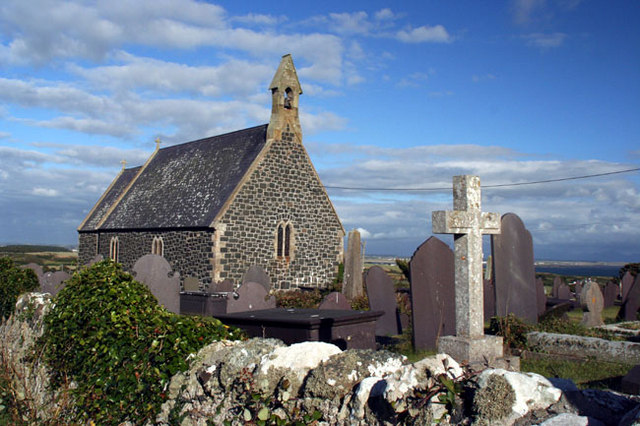
Rhoscolyn in the south-west corner of Holy Island gets its name, meaning 'the moor of the column', from a column erected by the Romans - one of many such columns which were put up to commemorate victories and to mark the boundaries of the Romans' conquered territories.  To the west of the village is Rhoscolyn Head, with St Gwenfaen's Well, the remains of a probably medieval dry stone well house which lies near the cliff top next to the coastal path.  Back in the village St Gwenfaen, who was the daughter of Pawl Hen of Manaw (Isle of Man), also lends her name to the village church, a simple grey stone structure on an elevated patch of ground with spectacular views.  The present-day church dates from around 1870 and incorporates some features from an earlier 15th century church which succumbed to a fire, although originally there was a church built here as early as the 6th century. 

The coast around Rhoscolyn is characterised by rocky headlands and small bays, chiefly Borthwen, a tiny bay with a curved beach backed by dunes, and Silver Bay.  These two bays are popular with sea kayakers and other watersports practitioners and there are rock pools to explore.  Just offshore is Ynysoedd Gwylanod (Gull's Island), which is topped by a navigational beacon erected after the Borthwen lifeboat station was closed.  As elsewhere in Anglesey, the brave lifeboatmen of Rhoscolyn were called upon to help out many a ship in distress.  One such was the Timbo, a steamship which got into trouble in seas so treacherous that the lifeboat crew, after several valiant attempts to come to the aid of the Timbo, were forced to turn back.   Sadly the lifeboat capsized and five of the crew members died, along with four of the Timbo's men.  There is a memorial to the five lifeboatmen who lost their lives in Rhoscolyn churchyard.   

Map of the area. 


File:The cemetery and Church - geograph.org.uk - 1040479.jpg
The cemetery and Church - geograph.org.uk - 1040479. Photo by Bob Shires, via Wikimedia Commons.

Sunday, 2 March 2014

TREARDDUR BAY


Holy Island, off the north-west of Anglesey, has the appearance of being 'pinched' in the middle, and at this pinch point on the west side of the island is the beautiful Trearddur Bay with its Blue Flag beach at the centre and a series of rocky coves on either side of the beach.  There is an ancient burial ground at the centre of the beach which was excavated in 2003, a reminder of the earlier existence of Tywyn y Capel, or Towyn Capel, the original name for the bay.  There are a variety of watersports available in the bay, including surfing, canoeing, sailing and wind-surfing.  There is a sailing club which holds an annual regatta.  At the southern end of the bay is the Porth Diana Nature Reserve, where the main draw for botanists is the very rare Spotted Rockrose, Anglesey's county flower.  

Live streaming webcam view of Trearddur Bay.

Map of the area. 


File:Trearddur Bay - geograph.org.uk - 699381.jpg
Trearddur Bay - geograph.org.uk - 699381. Photo by David C Williams, via Wikimedia Commons.