Labels

Aberdeenshire (21) Angus (4) antiquities (87) Argyll and Bute (35) Arran (7) art (37) birds (231) bridge (9) Caithness (12) Carmarthenshire (5) castle (164) Ceredigion (9) Channel Islands (13) Cheshire West and Cheshire (1) City and County of Swansea (1) City of Bristol (2) City of Edinburgh (4) Conwy (8) Cornwall (74) County Antrim (19) County Down (23) County Durham (3) County Londonderry (4) Cumbria (19) Denbighshire (2) Devon (48) diving (9) Dorset (18) Dumfries and Galloway (22) Dundee City (1) East Lothian (6) East Sussex (16) East Yorkshire (6) English Riviera (3) Essex (17) Fife (19) Flintshire (1) food (12) fossils (14) gardens (28) Ghosts (36) Glamorgan (1) Gower (7) Guernsey (4) Gwent (1) Gwynedd (19) Hampshire (13) Highland (72) Inner Hebrides (42) Inverclyde (5) Islay (8) Isle of Anglesey (14) Isle Of Man (7) Isle Of Wight (10) Isles of Scilly (3) Jersey (7) Kent (22) Lancashire (8) Lewis and Harris (7) lighthouse (62) Lincolnshire (8) Merseyside (8) Mid Glamorgan (1) mining (23) Moray (10) Mull (8) Norfolk (21) North Ayrshire (13) North Yorkshire (12) Northern Ireland (45) Northumberland (17) Orkney (10) Outer Hebrides (14) Pembrokeshire (27) pubs (50) Ross and Cromarty (20) Scotland (299) Scottish Borders (3) Shetland (14) shipwrecks (42) Skye (12) smuggling (48) Somerset (9) South Ayrshire (6) South Glamorgan (5) South Gloucestershire (2) Suffolk (18) surfing (92) Sutherland (16) Tyne and Wear (8) Wales (93) wartime (75) webcams (232) West Dunbartonshire (3) West Glamorgan (9) West Sussex (9)

Wednesday, 6 April 2011

ALDERNEY

It says a lot about the quirky nature of this friendly island, the third largest of the Channel Islands, but with an area of just four and a half square miles, that the airport lounge contains a box of knitting with an invitation to passengers to indulge in the creation of knitted squares while waiting for their flights. In spite of its small size, Alderney still manages to pack in 50 miles of walking paths, making it ideal for anyone wanting to explore the island courtesy of their own legpower. For wildlife enthusiasts, walking and wildlife can easily be combined thanks to the Alderney Wildlife Trust, which organises guided walks. Alderney’s most intriguing four-legged inhabitant is a rare blonde-haired hedgehog which you may glimpse at night if you’re lucky. Meanwhile, for the birdwatchers, there are 260 species of bird, including puffins and gannets.

Alderney has a history stretching back 10,000 years, with evidence of human habitation as far back as Neolithic times. The island also has some Roman remains. Alderney was once part of France, but gained independence in 1204. However, the threat from France was never very far from the minds of the islanders, and in the 19th century there was a big push to fortify the island, not surprisingly since France is visible from Alderney, being only 9 and a half miles away at its closest point. In the 20th century, the islanders’ fears of invasion proved founded, but this time not on the part of the French, but by Germany as, like its neighbours, Alderney was occupied during the Second World War. The island is still dotted with reminders of that time. The capital of Alderney, St Anne, has a population of around 2,000, which is most of the inhabitants of the island. During the War, the Luftwaffe built a bunker and tower in the town, which became the HQ of the German Defence Forces.  On the first Sunday in May a celebration of the tradition known as Milk-o-Punch takes place, in which punch consisting of rum, eggs, nutmeg and milk is served free in all the pubs.  The tradition harks back to when toasts were drunk in the fields when putting the cattle out to summer pasture.

For events in Alderney, follow this link..

Live streaming webcam view of the harbour from Mainbrayce Chandlery.

Map of Alderney.


File:Alderney - Braye Bay.jpg
Alderney - Braye Bay.  Photo by Andree Stephan, via Wikimedia Commons.

MOULIN HUET BAY

The French painter Pierre-Auguste Renoir visited Guernsey in 1883, and while there he became so captivated by the bay at Moulin Huet that he produced a series of paintings of this beauty spot on the Guernsey coast. An example of his work can be seen at the National Gallery. The lovely sand gracing this beach is best enjoyed at low tide when there is more of it to go around. An 1837 issue of “The Guernsey and Jersey Magazine” includes an ode to this place, which begins:

Moulin Huet Vale is dark and steep
Moulin Huet Bay is broad and deep
In crystal blue its waters sleep
And through the glassy tide
The finny tribes of ocean glide
And sea-birds o’er its surface sweep

Map of Guernsey.

File:Moulin Huet Bay, Guernsey - geograph.ci - 112.jpg
Moulin Huet Bay, Guernsey - geograph.ci - 112. Photo by John Rostron, via Wikimedia Commons.


Tuesday, 5 April 2011

PERELLE BAY/LIHOU ISLAND

Perelle Bay is a rocky bay on one of the most rugged parts of the Guernsey coast. It is home to a clutch of megalithic remains, such as Le Trepied Passage Grave at Le Catioroc and Le Creux es Faies Dolmen on the road to L’Eree promontory. Lihou is a small island connected to Guernsey by a stone causeway. There is a priory on the island believed to have been established in the 12th century by Benedictine monks. The local people were very wary of the monks, believing them to indulge in devil worship. In most cases this was patently unjustified, but there was one particular prior known as The Wicked Prior of Lihou who was rumoured to be in league with the devil, and who had an unhealthy interest in magic and what were referred to as The Black Books. However, legend has it that the prior was effectively destroyed by his own spells when a servant accompanying him on a visit to a nearby parish whose priest was also engaged in the Black Arts ignored the prior’s instructions not to read a book of spells the servant was carrying for him. The servant managed to cast a spell from the book which caused the sea to engulf the prior as he was crossing to the island along the causeway. There is a house on the island which was used by the Germans during the Occupation for target practice, but which is now used for accommodating school groups on educational visits.

Map of Guernsey.


File:Lihou Island and causeway - geograph.ci - 28.jpg
Lihou Island and causeway - geograph.ci - 28. Photo by David P Howard, via Wikimedia Commons.


Sunday, 3 April 2011

L'ANCRESSE/PEMBROKE BAY

One of the biggest bays on Guernsey, L’Ancresse, also known as Pembroke Bay, is a magnet for watersports enthusiasts such as windsurfers, surfers and sea kayakers. It also boasts a golf course, for more land-loving sports enthusiasts. Pembroke Bay was the venue for an unusual record-breaking event in 2008, when nearly 2,000 islanders turned up with teddy bears of all shapes and sizes to form a human/teddy bear chain, breaking the previous record of 631.

During the turbulent, war-torn years of the 1700s a series of defensive structures such as martello towers were erected on Guernsey, and there are a number of 18th century towers dotted around this area, providing a defence against large troop landings. Another fortification in Pembroke Bay is Star Fort, a star-shaped earthwork defence. Just around the coast from this location is a much older site of interest, Les Fouaillages, the metalithic site of what is thought to have been a monumental tomb, in a place where human activity of one kind or another is believed to date back to 8,000 years ago.

Map of the area.


File:L'Ancresse Bay - geograph.ci - 25.jpg
L'Ancresse Bay - geograph.ci - 25. Photo by Jonathan Wilkins, via Wikimedia Commons.


ST PETER PORT, GUERNSEY

St Peter Port, the main town of Guernsey, has an appealing town centre, made all the jollier by the presence of some brightly coloured buildings in some of its main streets. The busy harbour is reached by the narrow ‘gunelles’ or alleys which lead down to it. Cornet Rock, reachable by a breakwater and bridge, has been the site of a succession of castles, the first having been begun in the 13th century. The present-day castle is open to visitors and houses a number of museums, including a Maritime Museum and a Militia Museum. Another attraction for visitors is Hauteville House, which was occupied by Victor Hugo following his exile from France in 1851. It was here that he wrote Les Miserables. He went first to Jersey, but settled in Guernsey after falling for the island. He is commemorated by a statue in Candle Gardens.

Like Jersey, Guernsey suffered a period of occupation during World War II. The island’s liberation took place on 8 May 1945, when an Allied task force headed by HMS Bulldog arrived off St Peter Port. A few days after the liberation, the press reported on a “great convoy of mercy” as food and other supplies were brought to the island.

For events on the island through the year, see here.

Map of the area.

File:St Peter Port Guernsey.jpg
St Peter Port Guernsey. Photo by Alistair Young, via Wikimedia Commons.


Saturday, 2 April 2011

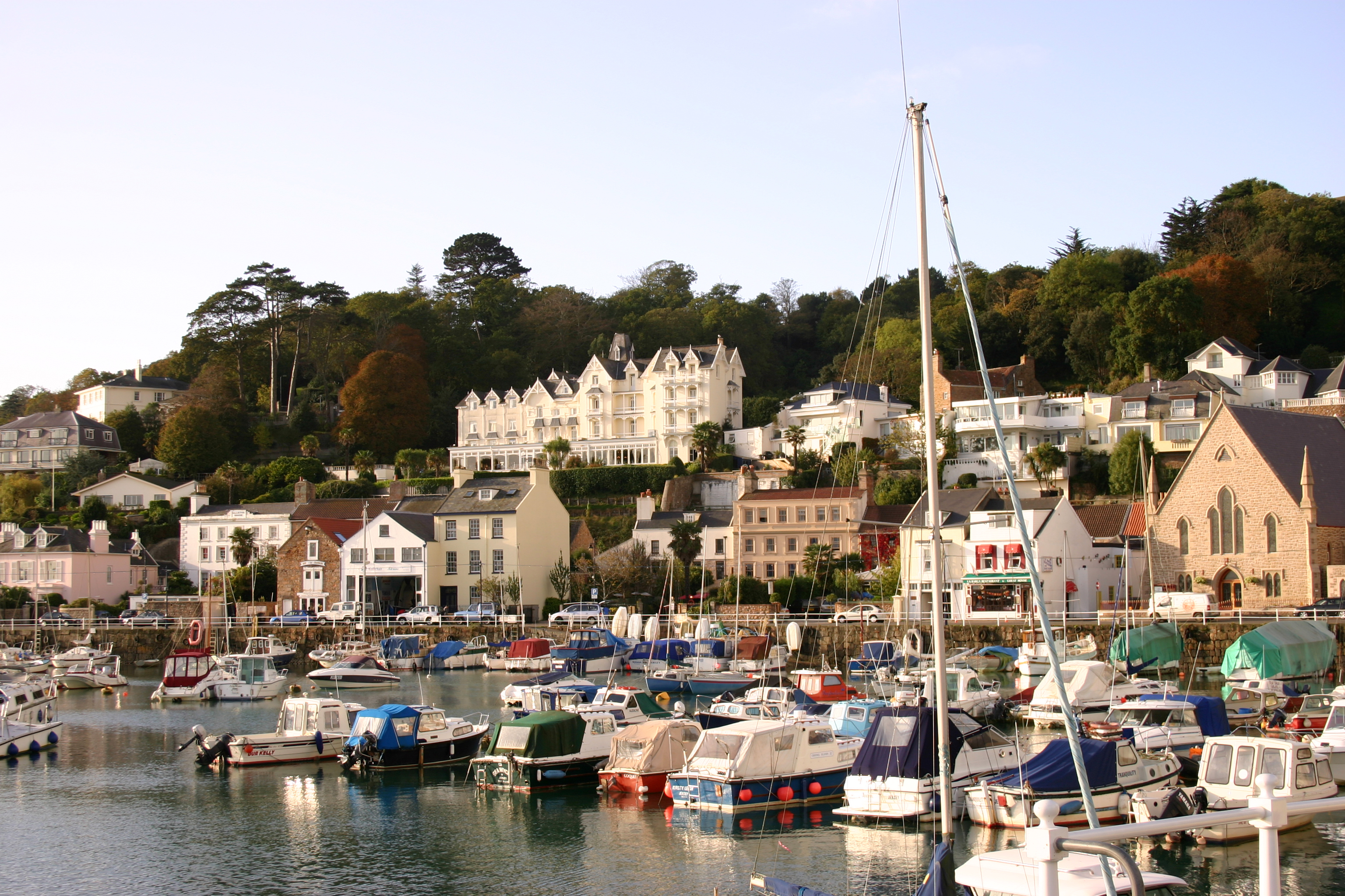
ST AUBIN

St Aubin is at the opposite end of the bay from the island’s capital. It forms part of the parish of St Brelade, and in fact the Parish Hall is located in St Aubin, in a former railway station. The railway line which used to go from here is now closed; for a time during the war it was used by the occupying German forces, but closed soon after. Like many former railway lines in Britain, it has been converted into a walking trail, linking St Aubin with Corbiere, a distance of 6km. As well as the wonderful plantlife and trees which can be enjoyed along this trail, if you are lucky you may glimpse the odd red squirrel.

A few miles inland from St Aubin is probably Jersey’s most memorable wartime site, the War Tunnels, which were built into the hillside and used as a barracks and for storing ammunition. Exhibits inside paint a fascinating picture of what life on Jersey was like during the German occupation. 

Live streaming webcam view from Panorama Guest House.

Map of the area.


File:St Aubin Jersey.jpg
St Aubin Jersey. Photo by Marilyn Peddle, via Wikimedia Commons.


Friday, 1 April 2011

ST BRELADE/PORTELET BAY

St Brelade’s Bay has a big, sweeping crescent shaped beach lined with hotels, restaurants and cafes. Overlooking this enticing scene is the St Brelade parish church, which has alongside it the Fishermen’s Chapel, which, dating from the 11th century, is older than the church. During restoration work frescoes from the 14th century were discovered in the chapel, the one in best condition depicting The Annunciation.  The parish of St Brelades is named after a Welsh saint, allegedly the son of Kenen.

Such is the appeal of the nearby highly picturesque Portelet Bay that it is often used in promotional material for Jersey tourism. The golden sandy beach is lovely, but escapes the worst crowds due to the long descent down via steps. Of course what goes down must come back up, but there is a pub at the top with lovely views where any thirst brought on by the climb can be quenched. There is a large rock just off the beach reachable by a short causeway – a kind of baby St Michael’s Mount – with a small martello tower on top dating from 1818. There is a sad story attached to this island, which is called l’Ile au Guerdain, or Janvrin’s tomb. Philippe Janvrin was a local seaman who in 1721 died of plague while out at sea. Due to the hysteria surrounding this particular disease the locals would not allow the body on land, but instead allowed it to be buried on the island, although it was later moved to nearby St Brelade.

Map of the area.

File:L'Île au Guerdain Jersey.JPG
L'Ile au Guerdain Jersey. Photo by FoxyOrange, via Wikimedia Commons.