Labels

Aberdeenshire (21) Angus (4) antiquities (87) Argyll and Bute (35) Arran (7) art (37) birds (231) bridge (9) Caithness (12) Carmarthenshire (5) castle (164) Ceredigion (9) Channel Islands (13) Cheshire West and Cheshire (1) City and County of Swansea (1) City of Bristol (2) City of Edinburgh (4) Conwy (8) Cornwall (74) County Antrim (19) County Down (23) County Durham (3) County Londonderry (4) Cumbria (19) Denbighshire (2) Devon (48) diving (9) Dorset (18) Dumfries and Galloway (22) Dundee City (1) East Lothian (6) East Sussex (16) East Yorkshire (6) English Riviera (3) Essex (17) Fife (19) Flintshire (1) food (12) fossils (14) gardens (28) Ghosts (36) Glamorgan (1) Gower (7) Guernsey (4) Gwent (1) Gwynedd (19) Hampshire (13) Highland (72) Inner Hebrides (42) Inverclyde (5) Islay (8) Isle of Anglesey (14) Isle Of Man (7) Isle Of Wight (10) Isles of Scilly (3) Jersey (7) Kent (22) Lancashire (8) Lewis and Harris (7) lighthouse (62) Lincolnshire (8) Merseyside (8) Mid Glamorgan (1) mining (23) Moray (10) Mull (8) Norfolk (21) North Ayrshire (13) North Yorkshire (12) Northern Ireland (45) Northumberland (17) Orkney (10) Outer Hebrides (14) Pembrokeshire (27) pubs (50) Ross and Cromarty (20) Scotland (299) Scottish Borders (3) Shetland (14) shipwrecks (42) Skye (12) smuggling (48) Somerset (9) South Ayrshire (6) South Glamorgan (5) South Gloucestershire (2) Suffolk (18) surfing (92) Sutherland (16) Tyne and Wear (8) Wales (93) wartime (75) webcams (232) West Dunbartonshire (3) West Glamorgan (9) West Sussex (9)

Tuesday, 24 January 2017

ST MARTIN'S, ST AGNES AND BRYHER, ISLES OF SCILLY


St Martin’s is the third largest inhabited island on the Isles of Scilly, and its three settlements are imaginatively named Higher Town, Middle Town and Lower Town.  The island houses the Scillies’ only Ordnance Survey triangulation station, and nearby is a striking red and white striped tower with a conical top known as the Daymark which, though erected in a relatively recent 1683, is a Scheduled Ancient Moument.  Being the most northerly island in the archipelago, the Daymark is the first thing passengers crossing from the mainland catch sight of when approaching the Scillies.  In spite of its diminutive size, St Martin’s manages to find room for a vineyard, the most south-westerly in England.  There are tours available in the summer months.  Another popular activity on the island is the seal snorkelling for those who want to get up close to these lovable creatures.  Other than that, there is a pub, a fish and chip restaurant and a scattering of accommodation options, but the main attraction here is the natural beauty and the wonderful views.

St Agnes includes the southernmost settlement in England, at Troy Town Farm.  A sandbar connects the island to another island called Gugh, so that at low tide they become one island, though the sandbar disappears at high tide, cutting off Gugh’s three residents.  St Agnes is the island to head for if you are a birdwatcher, with over one-third of its area designated a Site of Special Scientific Interest.  September and October are the busiest birdwatching months, jokingly referred to as the “Scilly Season”.  Many “firsts” have been spotted, including a number of ‘vagrant’ birds.  As for flora, Wingletang Down is the only place in Britain where the fern type ‘least adder’s-tongue’ can be found.  The area is also notable for its ancient sites: over forty Bronze Age cairns have been found there.  For overnighters, there are a small number of bed and breakfasts, and refreshments available from several outlets including the island’s only pub.

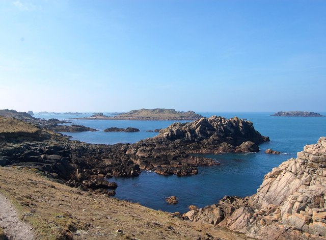
Bryher is the smallest of the inhabited islands in the Scillies archipelago, but in spite of its size there is a marked contrast between the wave-battered west coast and the tranquillity of the sheltered side facing Tresco and of Rushy Bay in the south.  The island is also big enough for a hill, Samson Hill, with its Bronze Age cairns.  Added to which it boasts a bar hailed as one of Britain’s best boozers by Jamie Oliver, and an award-winning hotel with the misleading name Hell Bay, which belies the luxurious offerings therein.  The name comes from the adjacent stretch of coastline which has received a battering over the years by waves crashing in from the Atlantic.  Bryher has even done a turn on the big screen, being the backdrop for the film Why The Whales Came, based on a book by regular visitor Michael Morpurgo.  

Live streaming webcam view of Bryher courtesy of the Hell Bay Hotel

Map of the islands

St Agnes from St Mary's, by Barbara Ashley

File:Hell Bay, Bryher - geograph.org.uk - 401278.jpg
Hell Bay, Bryher - geograph.org.uk - 401278. Photo by Ian Davison, via Wikimedia Commons.

Monday, 9 January 2017

TRESCO, ISLES OF SCILLY


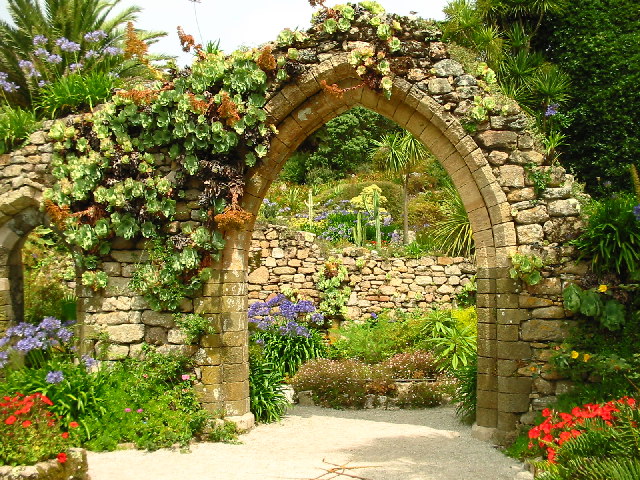
In an archipelago known for its subtropical climate, Tresco is the most subtropical island of them all, largely courtesy of the Tresco Abbey Garden, a riot of palms and other exotica set alongside a ruined 12th century priory, and including a collection of ship figureheads in the Valhalla Museum.  The gardens were started by a Hertfordshire squire called Augustus Smith who leased the islands from the Duchy of Cornwall in 1834, and who built Tresco Abbey as his home beside the existing ruins. 

Tresco is  just two and a half miles long and a mile wide at its widest point and is one of just five inhabited islands out of the 200-odd islands which make up the archipelago. For such a small piece of land Tresco has seen a surprising amount of action in the past, with three English Heritage properties acting as reminders of the island’s history.   The Old Blockhouse, also known as Dover Fort, was built in the mid-16th century by the government of Edward VI as protection against attack by the French.  The fort was occupied by the Royalists following the English Civil War and was attacked by Parliamentary forces in 1651.  King Charles’s Castle was another initiative of Edward VI,  and was garrisoned by Royalists during the Civil War.  Following the attack in 1651 a third fort was built called Cromwell’s Castle.  This round tower overlooking the stretch of water between Tresco and Bryher is one of Britain’s few surviving Cromwellian fortifications.

Meanwhile, for nature lovers there are two fresh water pools near the Abbey Garden with several hides for watching birds such as dunlins and plovers.  The pools are visited by migratory birds during spring and autumn.  For those who can’t bear to leave this balmy paradise, there is accommodation on the island as well as a number of refreshment options.  Tresco can be reached via a short boat crossing from the main island in the archipelago, St Mary’s.

Live streaming webcam view towards Bryher, courtesy of The Flying Boat.


File:The Abbey Garden, Tresco - geograph.org.uk - 15825.jpg
The Abbey Garden, Tresco - geograph.org.uk - 15825. Photo by Darren Smith, via Wikimedia Commons.

Saturday, 31 December 2016

ST MARY'S, ISLES OF SCILLY


When I was growing up in Penzance in the 1960s during Harold Wilson’s time as Prime Minister you could guarantee that every summer, regular as clockwork, the local news would feature the arrival of the PM at Penzance station en route to his holiday retreat on the island of St Mary’s.  On arriving at the station he would transfer to the Scillonian for the choppy crossing to the Scillies, then he and his wife Mary and their two sons would set up in their three-bedroom bungalow, Lowenva, a Cornish word meaning “house of happiness”.  Wilson’s idyllic time on the island nearly came to a dramatic end in 1973, when he got into difficulties trying to get into a rubber dinghy.  His submersion in the cold water brought him close to death, but luckily a passing family from Rugby were able to fetch a boat to rescue him with.

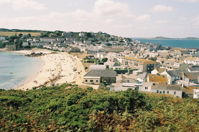
The sea crossing, now on the Scillonian III, is still going, but the helicopter service that once supplemented it ended in 2012, prompting fears among the Scillonians that economic decline would ensue.  However, earlier this year it was reported that a multi-million pound investment was being unveiled for a resumption of the helicopter crossing.  An alternative air crossing is available from Land’s End Airport.  St Mary’s is the largest island in the Scillies, and the main town is Hugh Town, which occupies a narrow neck of land to the south-west of the island, between Porthcressa Beach and Town Bay.  This is where the Scillonian anchors, and  inter-island boat trips set off from here.  There are also round island coach tours available from Hugh Town which are geared up for day trippers off the Scillonian. At the southern edge of town is the Buzza Neolithic Tomb, which is worth walking up to if only for the view. The busiest time of the year is during May Day bank holiday weekend, when the World Pilot Gig Championships are held. For a list of events on the islands, follow this link.


File:Hugh Town - geograph.org.uk - 473796.jpg
Hugh Town - geograph.org.uk - 473796. Photo by Chris Downer, via Wikimedia Commons.

Saturday, 17 December 2016

SENNEN


When I was growing up in Cornwall Sennen was one of my favourite places to go to the beach, with the long sweeping sands of Whitesands Beach backed by sheltered dunes.  Sennen is one of Cornwall’s most popular surfing spots, and not wanting to miss out on the action, I acquired a polystyrene child’s surfboard which was meant to be used lying down.  However one day, in a fit of surfing dude envy, I decided I was going to stand on it and it promptly broke, and that, sadly, was the end of my surfing ambitions.

The village itself is small, with a pub and a small collection of cafes and shops, and a gallery which occupies a building known as the Roundhouse, a distinctive round building which was erected in 1876 to house a large capstan wheel which was previously open to the elements.  And the elements here can be dramatic, given Sennen’s exposed location at the end of the country.  In February 2014 the village was battered by a monster storm during which massive waves up to 200 feet crashed over the shore.  Follow this link for footage of the action.  Up the hill from the village is another pub called the First And Last Inn which is famous for being haunted by a landlady from the 1800s called Annie George.  She was left to drown on the beach after giving evidence of the actions of a notorious local smuggler.  She has been seen roaming the corridors and in her old bedroom, and other manifestations include glasses moving of their own accord.  Sennen was a hive of smuggling activity at that time, when ‘wreckers’ would lure ships to the rocks, kill the crew and loot the cargo.  Tunnels at the pub were used to conceal the contraband.

From Sennen, the South West Coast Path heads past the Mayon Old Coastguard Lookout, and barely a mile further on we come to Land’s End, which is where I started this blog in January 2011!  But don’t go away, because there’s still the Scillies and the coast of Northern Ireland to come.

Map of the area.

Live streaming webcam of the beach.


Wednesday, 7 December 2016

CAPE CORNWALL AND ST JUST


Cape Cornwall is the second most prominent headland on the West Cornwall coast after Land’s End.  In my very first post at the start of this blog, I cautioned that Land’s End is not the cheap option it once was, due to the ‘Disneyfication’ of the site with a range of shops and attractions.  Some people like that sort of thing, but for those who do not, I strongly recommend a visit to Cape Cornwall, where you will get the same “end of the world” feeling without the fanfare.  There is a National Trust car park (free to members), and a refreshment van, and that is about it, apart from the Cape Cornwall Club just above the headland, which offers golf and accommodation.  For those who want to stretch their legs there is a path around the headland, and wonderful views of Land’s End and the Longships lighthouse.  The Cape is crowned by the chimney which is all that remains of the Cape Cornwall Mine, a tin mine which operated between 1838 and 1883.   Another option for walkers is the path descending from the car park to Priest’s Cove, from where the South West Coast Path heads southwards, passing Ballowall Barrow, a Bronze Age burial chamber (English Heritage, free entry).

Cape Cornwall is reached by a minor road from the vibrant small town of St Just, England’s most westerly town.  The town was a thriving hive of activity during Victorian times thanks to the area’s tin-mining activities.  Up to the 17th century medieval miracle plays were performed in Plain-an-Gwarry, the natural grassy amphitheatre in the centre of St Just, and this continues to be used today for more modern festivities such as the annual Lafrowda Festival in July, a colourful music and arts festival.  St Just is also home to the original Warren’s Bakery, founded in 1860, which now has branches all over the county, and which makes some of the best pasties around.

Live streaming webcam view of the Cape Cornwall Club golf course.

Map of the area. 

File:Cape Cornwall (Judithili).jpg
Cape Cornwall (Judithili). Photo by Judithili, via Wikimedia Commons.