Continuing the mining theme, just along the road from
Pendeen are the neighbouring villages of Botallack and Kenidjack. The mining landscape between the villages and
the coast path is some of the best in Cornwall, and includes the remains the
engine house Wheal Edward, part of the Wheal Owles Mine Sett. In 1893 Wheal Owles was the scene of a tragic
accident, when water came rushing in from a flooded neighbouring mine, a common
hazard in the Cornish mines, which often extended far out under the sea. 20 men were drowned in the accident, almost
half the men who were down the mine at the time. The Botallack Count House Workshop, owned by
the National Trust but free to enter, has information on mining in the area and on Poldark, as well as a
cafe, all housed in a building which performed an essential role as the place
where the miners went to collect their pay. The nearby Crowns Engine Houses in Botallack
occupy a dramatic position towards the lower end of the cliff, and featured in
the latest Poldark series. Kenidjack Headland is home to an Iron Age cliff castle, and there are
Bronze Age cairns in the area. The views of Cape Cornwall from here and, on a
clear day the Scilly Islands, are spectacular. If all this is not enough to tempt walkers
out onto the headland, birding enthusiasts will have the added pleasure of
keeping an eye out for peregrine falcons and Cornish choughs, identifiable by
their red bills.
Saturday, 26 November 2016


Thursday, 17 November 2016
PENDEEN
The village of Pendeen is strung out along the B3306, with
Carn Eanes, known locally as “The Carn”, towering over it. The moorlands above the village are dotted
with prehistoric sites and relics of the local mining industry. The village is separated from the coastal
path by fields with assorted farm animals.
Over in the distance the handsome whitewash lighthouse known as Pendeen
Watch, built in 1891, still lights up as soon as dusk descends, warning passing
ships off this treacherous stretch of coast.
The coastal path heading east from the lighthouse leads to the
delightfully secluded Portheras Cove.
Pendeen was otherwise known as Boskaswal Wartha, and the present-day
village is divided into Higher Boscaswell and Lower Boscaswell. Anyone wanting to get a sense of the
landscape around here should read ‘A Perfectly Good Man’ by Patrick Gale. My mother and stepfather live in the village, and reading this book the description of the main character’s house
and surroundings felt eerily familiar.

Between Pendeen and the neighbouring village of Trewellard
is the entrance to Geevor Tin Mine, which
offers tours of the old mine workings.
The mine was operational for a good part of the 20th century,
and owes its existence to a group of St Just miners who had emigrated to South
Africa but were forced to return due to the outbreak of the Second Boer
War. Being claustrophobic, I have not
been on the mine tour, in spite of its proximity to my relatives’ house. However, I can vouch for the novel experience
of walking through this evocative industrial landscape. It is a steep and uneven walk down to the
coastal path below, but well worth it for the chance to perch on the cliff top
and gaze down at the sea crashing against the rocks. Near Geevor Mine is the Levant Mine and Beam Engine, owned by the National Trust. Poldark fans may recognise it,
as it doubled up as Tressiders Rolling Mill in the TV series.
| Relics of the mining industry at Geevor |
 |
| Pendeen Lighthouse, by Barbara Ashley |
Map of the area.
Friday, 11 November 2016
GURNARD'S HEAD
This prominent headland on the stretch of coast between St
Ives and Lands End got its name from the fact that its shape is reminiscent of
the gurnard fish. There has always been
a lone pub on the headland as long as I can remember. Back in the day it was a normal, unassuming
St Austell Ales inn, but now, as a sign of the times, it has been turned into a
smart hotel and gastropub, no doubt a welcome stop along this wild coast for
those walking the South West Coast Path.
There is an iron age hill fort called Trereen Dinas (‘fort
at the farm on the point’) on the headland, the remnants of which can still
just about be made out in the form of a ditch and a bank with some drystone
walling. In the early 1800s there was a
copper mine named Wheal Treen in operation on Gurnard’s Head, but it fell into
disuse in 1877. Now there is just the
hotel and the nearby village of Treen.
The nearest beach to the headland is Treen Cove, a short distance to the
east of the headland. Probably not one
for families, as there are no facilities and no lifeguard cover, just the wild
beauty of the Atlantic breakers crashing on to the shore.
Map of the area.
 |
| Gurnard's Head, by Barbara Ashley |
Thursday, 27 October 2016
ZENNOR
The B3306 road heading west from St Ives has been described
as one of the country’s most spectacular drives. Having travelled that road many times myself,
I can testify to this fact. There is a
raw beauty out here, with the bleak West Cornwall moorlands rising up on one
side, and the churning Atlantic Ocean on the other. Several miles out of St Ives, the road
reaches the village of Zennor, with its medieval church and its pub the Tinners
Arms. D H Lawrence famously put up here
during the First World War when he arrived in 1916 with his German wife
Frieda. They stayed in the pub until
they found a cottage to rent – Higher Tregerthen was the cottage they settled
on, and can be found to the south of the village. It was while staying in Zennor that Lawrence
finished writing Women In Love. Lawrence
thought he had found paradise on earth in Zennor, which must have seemed a
world away from the horrors of war. However,
18 months months after their arrival the Lawrences were ordered to leave
Cornwall, having been wrongly accused of spying for the Germans. There has been a church on the site of the current village church, St Senara’s,
since at least the 6th century, although the present church was
rebuilt in the 12th century.
The most notable feature in the church is the Mermaid of Zennor, a
carving of a mermaid admiring herself in a mirror, which graces the Mermaid
Chair, believed to be at least 600 years old. Zennor Head is a short walk from the village, and is the nearest point on the South West Coast Path. A triangulation point on top of the headland records a height of 314 feet above sea level.
Map of the area.
 | |
| Zennor Head - geograph.org.uk - 912882. Photo by Row17, via Wikimedia Commons. |
Thursday, 20 October 2016
ST IVES
When I was growing up in Penzance I used to love jumping on the No. 17 bus to St Ives for the day (incredibly, several decades later it is still the No. 17). In truth, St Ives was a bit on the tacky side in those days, not that it bothered me as a child. However, that certainly cannot be said now, with a host of smart restaurants and upmarket accommodation options gracing the town. I read somewhere recently that St Ives is the most expensive place to stay in Cornwall, even outstripping Padstein, though there are still some affordable options for those on a budget.
The main factor that propelled the town into the touristic stratosphere, apart from its stunning appearance, was probably the opening of the Tate St Ives, the Cornish outpost of the famous London art gallery, which occupies a position overlooking Porthmeor Beach and which boasts a top floor cafe with sea views. St Ives was the obvious choice of location for the gallery, given its long-standing artistic pedigree. The town, which has always been celebrated by artists for its exceptional light, has for years it been a magnet, and not only for painters. One of the most famous names from the art world to live in the town was the sculptress Barbara Hepworth. Although she died in 1975, her memory lives on in the form of the Barbara Hepworth Museum and Sculpture Garden, which comes under the umbrella of the Tate. There is much to inspire artists living in and visiting the town, especially in the old quarter bordering the harbour, where ancient whitewashed fishermen’s cottages line the winding alleyways. Needless to say, a large proportion of these cottages have been turned into holiday homes.
The other big draw for visitors to St Ives is the town’s fabulous beaches. As well as the above-mentioned Porthmeor Beach, the other main beach is Porthminster, just below the railway station. Both beaches are gloriously sandy, and both have smart restaurants for more upmarket grub as a change from the ubiquitous pasties and fish and chips. In between the two is the harbour, with another small beach, and then there is the ‘Island’, not actually an island but a small promontory with a chapel on top. The diminutive St Nicholas Chapel, also known as the Island Chapel, dates back to at least the 15th century, though no-one is sure when exactly. Seals and dolphins can sometimes be seen from the area near the coastwatch station on the Island. Further along the coast is Seal Island, visited by boat trips from the harbour. Back in the fishermen's quarter, the St Ives Museum, occupying a building once used for pilchard curing, is a treasure trove of memorabilia from the town's past. Another museum is the Capt Sir Richard Francis Burton Museum, dedicated to the exploits of a Victorian adventurer, explorer, spy and translator of the Kama Sutra.
As is to be expected from such a popular tourist town, there are a plethora of takeaways for those wanting to enjoy a bite to eat al fresco. However, I feel I must issue a word of warning for anyone tempted to indulge in takeaway food outside, particularly in the vicinity of the harbour: seagulls! The seagulls of St Ives must surely be the biggest in the country, and they have acquired an almost mythical reputation for their voracity and their brazenness in their quest for free grub. As an example, a few years ago I was wandering by the harbourside tucking into an ice cream. Suddenly a gull appeared from behind at great speed and snatched the ball of ice cream from the cone. I was just getting over the shock of that when another one came along and snatched the cone, leaving me with nothing. The only consolation was that it provided a good deal of entertainment for a little boy passing nearby with his dad.
St Ives hosts a number of festivals and other events throughout the year. For a list of events in the town follow this link.
Webcam view of the harbor.
Webcam view of the harbor.
Map of the area.
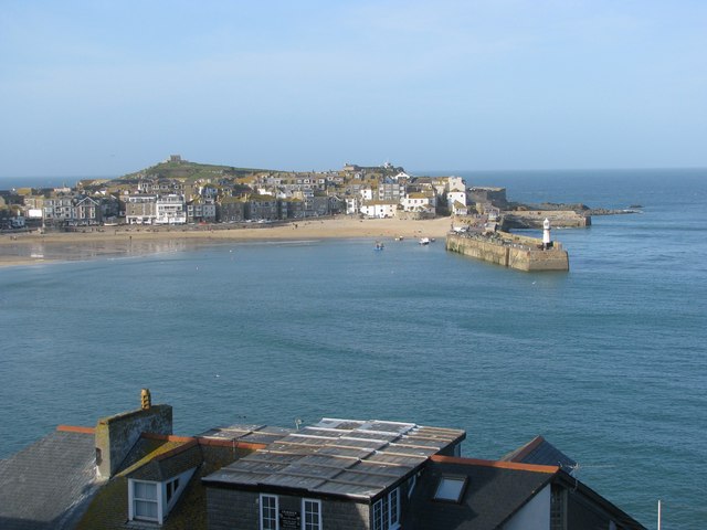 | |
| St Ives Harbour over the rooftops - geograph.org.uk - 1206991. Photo by Sarah Charlesworth, via Wikimedia Commons. |
Thursday, 13 October 2016
CARBIS BAY
When I was growing up in West Cornwall, my mother packed me
off to Sunday School each week. Every
summer the Sunday School took us all off to Carbis Bay for our annual day out
on the beach. Part of the deal was a
lunch consisting of a pasty and a saffron bun.
For those not in the know, a saffron bun is a Cornish delicacy,
basically a large yellow-coloured currant bun.
To this day I think of Carbis Bay every time I see a saffron bun, a
happy thought indeed, this being a delightful spot on the West Cornwall
coast. The beach is sandy, overlooked by
a leafy subtropical backdrop and with exceptionally calm waters, unusual for
the beaches around here. The village can
be reached by train via the branch line from St Erth to St Ives. Carbis Bay is just around the coast from St
Ives, and there is a pleasant coastal walk linking the two. The village itself has a small selection of
places to eat and drink and a range of holiday accommodation. The church is dedicated to St Anta (the saint
who gave rise to the name of neighbouring Lelant – see previous post).
The higher ground around here is dominated by a distinctive granite memorial with the appearance of a pointy witch's hat. This is Knill's Monument, originally erected as a mausoleum for the remains of former Mayor of St Ives, John Knill.
The higher ground around here is dominated by a distinctive granite memorial with the appearance of a pointy witch's hat. This is Knill's Monument, originally erected as a mausoleum for the remains of former Mayor of St Ives, John Knill.
Live streaming webcam view of the beach, courtesy of Carbis Bay Holidays.
Map of the area.
 | |
| Carbis Bay - geograph.org.uk - 1003367. Photo by Alan, via Wikimedia Commons. |
Subscribe to:
Posts (Atom)