Labels

Aberdeenshire (21) Angus (4) antiquities (87) Argyll and Bute (35) Arran (7) art (37) birds (231) bridge (9) Caithness (12) Carmarthenshire (5) castle (165) Ceredigion (9) Channel Islands (13) Cheshire West and Cheshire (1) City and County of Swansea (1) City of Bristol (2) City of Edinburgh (4) Conwy (8) Cornwall (74) County Antrim (19) County Down (23) County Durham (3) County Londonderry (4) Cumbria (19) Denbighshire (2) Devon (48) diving (9) Dorset (18) Dumfries and Galloway (22) Dundee City (2) East Lothian (6) East Sussex (16) East Yorkshire (6) English Riviera (3) Essex (17) Fife (19) Flintshire (1) food (13) fossils (14) gardens (28) Ghosts (35) Glamorgan (1) Gower (7) Guernsey (4) Gwent (1) Gwynedd (19) Hampshire (13) Highland (72) Inner Hebrides (42) Inverclyde (5) Islay (8) Isle of Anglesey (14) Isle Of Man (7) Isle Of Wight (10) Isles of Scilly (3) Jersey (7) Kent (22) Lancashire (8) Lewis and Harris (7) lighthouse (62) Lincolnshire (8) Merseyside (8) Mid Glamorgan (1) mining (23) Moray (10) Mull (8) Norfolk (21) North Ayrshire (13) North Yorkshire (12) Northern Ireland (45) Northumberland (17) Orkney (10) Outer Hebrides (14) Pembrokeshire (27) pubs (47) Ross and Cromarty (20) Scotland (300) Scottish Borders (3) Shetland (14) shipwrecks (42) Skye (12) smuggling (48) Somerset (9) South Ayrshire (6) South Glamorgan (5) South Gloucestershire (1) Suffolk (18) surfing (84) Sutherland (16) Tyne and Wear (8) Wales (93) wartime (75) webcams (232) West Dunbartonshire (3) West Glamorgan (9) West Sussex (9)

Monday, 31 January 2011

ST MAWES

On the opposite side of the Fal estuary from Falmouth is a peninsula with the charming name of Roseland Peninsula, and at the tip of this peninsula lies St Mawes, which can be reached from Falmouth by ferry (foot passengers only) all year round, thus saving a winding 30-mile journey up the estuary and back down again. The name of the peninsula does not, as one might expect, derive from an abundance of roses growing on it, but from the Cornish word ‘ros’ or ‘roos’, meaning promontory. The town of St Mawes includes one of two castles built to protect the mouth of the River Fal (see Falmouth post). The harbour has provided welcome shelter for many vessels over the years, including a fleet of 350, among them warships, which sought refuge from severe gales here in 1815.

Today, the town is above all frequented by yachts taking advantage of its sheltered position just out of reach of the dangers of the open sea, and it has its own Sailing Club. Perhaps because of this, it is a rather upmarket resort, while still retaining a fishing fleet. The main beach in the town is Summers Beach, a small and quiet beach that offers stunning views.  Meanwhile, for dedicated beach bums, there are a couple of good, safe beaches near the harbour.  The town is also home to the Roseland Visitor Centre, which provides information about St Mawes and the Roseland Peninsula.

Map of the area.

File:View of St Mawes.jpg
View of St Mawes. Photo by Stmawesinfo, via Wikimedia Commons.

St Mawes from St Anthony Head. Barbara Ashley.


Sunday, 30 January 2011

FLUSHING

It is no coincidence that this village on the opposite bank of the Penryn river from Falmouth shares its name with a city in the Netherlands, aka Vlissingen. The Cornish Flushing was originally called Nankersey, or “valley of the reed swamp”, but was renamed Flushing by the Dutchmen who built the three main quays here. The village is graced with a number of impressively grand houses, built by various ships’ captains who decided to settle here. By the 1800s the mild climate was proving a draw for those with a sickly disposition.

Nowadays, Flushing’s main draw is the annual regatta, which consists of far more than just a mass of yachts bobbing around the surrounding waters. There are a host of fun activities such as a beach fun day, a Snail Grand Prix, Bath Tub Racing, to name but three, all liberally lubricated by the beverages served at the Royal Standard and Seven Stars pubs.

Map of the area.


File:Flushing (7832780736).jpg
Flushing (7832780736). Photo by Tim Green, via Wikimedia Commons.


Saturday, 29 January 2011

FALMOUTH

Thanks to its impressive geographical credentials, the town of Falmouth, at the mouth of the Fal estuary, has a long and rich maritime history. That well-known beheader of wives Henry VIII saw fit to protect the town with not one, but two castles, one one each side of the Fal estuary – Pendennis Castle on the west side, and St Mawes Castle on the east side. This was necessary to deter the would-be enemy invaders, including the Spanish Armada, who considered the natural harbour here a pushover, it being the third deepest natural harbour in the world. The following century, an important shipborne mail service started up called the Falmouth Packet, which provided a vital link between Britain and the countries of its Empire.

Falmouth is something of a town of two halves, with the estuary on one side and a couple of lovely beaches on the other: Gyllyngvase Beach and Swanpool Beach.  The town’s long maritime tradition continues to the present day, as one of the town's major tourist attractions is the National Maritime Museum, which in summer can be reached by catching a “park and float” ferry from a car park further down the estuary.  There are also a number of boat trips and ferry services available from the Custom House Quay and the Prince of Wales Pier. Near the museum is an attractive new development of waterside homes, some of which are available for holiday rentals. There are also a number of sea-based festivals, including a sea shanty festival in June and an oyster festival in October. Falmouth also plays host to the Cornwall Film Festival, and the Greenbank Fal River Festival. For a list of events in the town follow this link.

Live streaming webcam view of the estuary

Map of the area.

Boats in the River Fal


View of the beach


Friday, 28 January 2011

MAENPORTH

Maenporth is an obscure spot on the Cornish coast, at least I’d never heard of it until I started this blog. However, this little-known place was the subject of a poem by Peter Redgrove, a poet who lived in Falmouth during his later years, who in 1967 wrote a poem with the strange title “The Idea of Entropy at Maenporth Beach”, one of a series of “mud-people poems”. So Maenporth has earned its place in the international Hall of Fame! The small but perfectly formed beach here is situated on the stretch of coast between the Helford River and the River Fal, and offers beautiful views of the coast beyond the Fal Estuary. Maenporth was the scene of yet another shipwreck, a Scottish trawler called the Ben Asdale, which ran aground in 1978. However, unlike the other shipwrecks in the area, you won’t have to don a wetsuit and oxygen tank to view this one, because it is still visible from land at low tide. A wetland area behind Maenporth provides the opportunity to view Grey Heron and Little Egret.

Map of the area.


File:Beach below High Cliff Maenporth - geograph.org.uk - 840100.jpg
Beach below High Cliff Maenporth - geograph.org.uk - 840100. Photo by Rod Allday, via Wikimedia Commons.


Thursday, 27 January 2011

TREBAH/GLENDURGAN

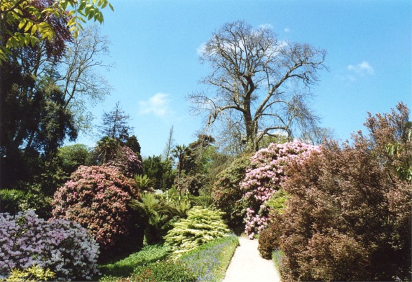
If you take the ferry across the Helford River (summer only) you could end up seriously geographically disoriented if you decide to visit the exotic gardens of Trebah and Glendurgan on the opposite bank. In a county with more than its fair share of wondrous gardens, these two stand out. The reason for the disorientation, apart from the curiously Scottish-sounding name of the latter garden, is that the gardens, like many of the gardens in Cornwall, are full of non-native plants brought to Cornwall by the Fox family who created them. From Monterey Pine, antipodean tree ferns, huge rhododendrons from the Himalayas and Chusan Palms from China in Trebah to the giant rhubarb in the ‘jungle’ of the lower valley of Glendurgan, and 8-foot tall agave plants – one of which was flowering when I was there, a rare occurrence apparently – a visit to these amazing gardens will leave you feeling like you have been on a whistle-stop tour of the world.

Glendurgan is run by the National Trust; Trebah, however, is owned by the registered charity Trebah Garden Trust.

Map of the area.


File:Glendurgan Garden, Cornwall - geograph.org.uk - 349411.jpg
Glendurgan Garden, Cornwall - geograph.org.uk - 349411. Photo by Tom Pennington, via Wikimedia Commons.


Wednesday, 26 January 2011

PORTHOUSTOCK/HELFORD

Many of the divers heading across to explore the wrecks off the Manacles set off from the tiny beach at Porthoustock, a coastal hamlet near St Keverne. A lifeboat station was established here in 1869 in response to the alarming number of wrecks caused by these treacherous rocks (see Coverack post) but it was closed in 1942, and has since become the village hall. The main economic activity in this place is quarrying, and during the war the stone quarried here was used to build the airfields in Cornwall. Not even this tiny, tranquil spot escaped the German bombing raids of the Second World War. During the night of November 8th 1940 18 bombs fell in the Porthoustock and St Keverne district, but mercifully they were spared both damage and casualties.

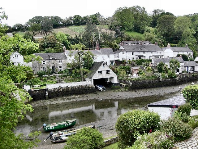
Following the coast around from Porthoustock, you will notice a change in the nature of the coastline, because this stretch of the South Cornwall coast is characterised by the ‘rias’, or drowned river valleys, each with a subset of smaller creeks and inlets. If I were to make a list of my top five most idyllic spots in Cornwall, Helford would be in that list. Nestling on the south bank of the Helford River, this beautiful, peaceful village was, believe it or not, once a major port, receiving goods by ship from the continent. It even had its own customs house. Needless to say there was no shortage of pirates and smugglers wanting to get in on the act. One of the nearby creeks is Frenchman’s Creek, immortalised by Daphne du Maurier in her book of the same name.

Map of the area.


File:Helford Village - geograph.org.uk - 9853.jpg
Helford Village - geograph.org.uk - 9853. Photo by Richard Johns, via Wikimedia Commons.


Monday, 24 January 2011

COVERACK

The first real village after the Lizard is Coverack, but before you get there, there is an interesting diversion en route in the form of Poldowrian Garden, which boasts magnificent clifftop views, and includes a prehistoric settlement discovered in 1965 and believed to date from 5500 BC. Coverack itself is yet another typical Cornish fishing village, but unlike Cadgwith, it is situated on a sweeping bay rather than a cove.

The coastline here begins to take on a gentler, less rugged appearance, but do not be fooled by this, because just offshore is possibly the most notorious group of rocks in Cornish waters, the Manacles. Even by Cornish standards the Manacles are a nasty piece of work, and over the years they have caused countless shipwrecks and contributed to considerable loss of life, both of the crew and passengers and of the brave lifeboat men who risked their lives to save them, as can be seen from a visit to the graveyards of nearby churches such as that of St Keverne. Nowadays these rocks provide a somewhat morbid playground for divers, while for windsurfing enthusiasts there is a windsurfing centre in Coverack.

Live streaming webcam view of the bay from the Bay Hotel.  

Map of the area.

                                 
Coverack (28695464066).jpg
Coverack (28695464066). Photo by John Shortland, via Wikimedia Commons.

CADGWITH

The charming little fishing village of Cadgwith ticks all the boxes for a typical Cornish fishing village. Whitewash thatched cottages – tick. Fishing boats hauled up on the tiny beach – tick. Ancient harbourside inn with regular singalongs led by the local singing group – tick. There is even a Cadgwith Anthem, though you shouldn’t let the lyrics of the first two lines put you off visiting this delightful place:

Come fill up your glasses and let us be merry
For to rob and to plunder it is our intent.

This song is believed to have been written by local residents who wanted to produce a folk song for the town, and the first known performance of it was by the Cornish Fishermans choir in 1953. A more recent version of it was recorded by Steeleye Span in 1975.

Cadgwith is still a working fishing village, with the fruits of the fishermen’s labours including such delights as crab, lobster, monkfish and shark, some of which can be enjoyed in the pubs and restaurants in the locality. If you want to work off your fish lunch, there is an interesting coastal feature which can be found by walking along the coastal path towards The Lizard called The Devil’s Frying Pan, so named because the geology surrounding it causes the water within it to “boil” during rough seas.

Map of the area.


Sunday, 23 January 2011

THE LIZARD

And so we come to the Lizard, the headland which forms the eastern end of Mounts Bay, and the most southerly point on the mainland of Britain, with its handsome white lighthouse. When I was growing up in the area, I often wondered where the name Lizard came from. It’s not like Cornwall is renowned for its lizard population. It turns out it is a corruption of “Lazars’ Point”, a lazar being an archaic word for a leper. This peninsula is a favourite haunt of geologists due to the abundant presence of the beautiful, veined rock called serpentine, a relic from the area’s violent geological past. This stone was once a popular adornment for posh buildings due to its decorative appearance, and many churches both here and further afield have serpentine fonts and so on. Nowadays it is most commonly found in the form of souvenirs sold in the gift shops of the locality.

A more modern-day feature of the peninsula, which can be seen from miles around, is the Goonhilly Satellite Earth Station, with over 60 dishes dotted about the landscape. The granddaddy of them all is a dish affectionally named Arthur, which in 1962 received the first live transatlantic television broadcast from the USA. Other dishes have similarly Arthurian names, such as Merlin, Guinevere. Actual operations at the site ceased in 2008, but it now has a new role in space missions. There was a visitor centre there until 2010, which sadly has closed until further notice, but there are plans to reopen the site to the public at some point.

Map of the area.


File:THE LIZARD LIGHTHOUSE AND FOGHORN - panoramio.jpg
THE LIZARD LIGHTHOUSE AND FOGHORN - panoramio. Photo by johanvanbetsbrugge, via Wikimedia Commons.


Saturday, 22 January 2011

KYNANCE COVE

Three years ago, a group of people walking near Kynance Cove, expecting a high from the sound of the crashing waves and the bracing fresh sea air, got more than they bargained for when they discovered several packages of cocaine with an estimated street value of millions of pounds. This was a rare 21st century tale of smuggling in a part of the world awash with a centuries’ old smuggling history. It is easy to imagine this spot as a mecca for smugglers, with its intricate cliffs, caves and rockpools, providing a wealth of hiding places for ill-gotten gains. The cove has had its share of distinguised visitors over the years, including Lord Tennyson and Prince Albert, not surprisingly given the beautiful white sand and turquoise water which grace this place. Offshore is a small island called Asparagus Island, named after the Asparagus Officinalis which grows there.

Map of the area.


Friday, 21 January 2011

MULLION COVE

By the time we come round to Mullion Cove, we are well into the Lizard Peninsula, the easternmost tip of Mounts Bay. The area immediately adjoining this tiny cove has had a disproportionately large number of shipwrecks, nine of them in the six years leading up to 1873 alone. The area was also rich in pirate and smuggling activity, and when in 1801 the group of neerdowells named the Mullion Musket Men got into a scrap with a gun vessel called HM Hecate, the smugglers of the locality were provided with a chance to exonerate themselves, being offered the King’s Pardon if they were able to provide any information on the perpetrators. The maritime theme is continued in the 13th century church of St Melan, whose benchend carvings include a depiction of Jonah and the Whale.

Today, all the violence and turmoil of the past is easily forgotten, since Mullion is an exceptionally tranquil and beautiful place to enjoy a coastal walk, or to admire the wares in the local Chocolate Factory and Craft Centre.  The harbour is still a working fishing harbour, and is protected from the worst of the gales by two sturdy sea walls. Nearby sea caves and resident seals can be viewed in the summer on boat trips.

Live streaming webcam.

Map of the area.

File:Mullion Cove (7993).jpg
Mullion Cove (7993). Photo by Nilfanion, via Wikimedia Commons.


Thursday, 20 January 2011

GUNWALLOE

The area around the fishing village of Gunwalloe has seen its share of maritime mishaps, including a shipwreck at Dollar Cove, so named because the ship in question, a Spanish ship called the San Salvador, was carrying a large quantity of silver dollars. To this day, some of the dollars are occasionally washed up on shore during stormy weather, so this is a good venue for the metal-detecting brigade. A more recent event that this area is noted for occurred on nearby Poldhu Head, from where, in 1901, Marconi transmitted the first ever translatlantic radio signals.

Those who are interested in unusual churches should seek out the Church of Saint Winwaloe in nearby Church Cove. This charming, weather-beaten little church sits at the edge of the beach, surrounded by a tamarisk hedge. It is unusual in that its tower is separate from the rest of the building; in fact it belonged to an earlier church which dated from a century or so earlier than the present-day church.

Map of the area.


File:Church Cove (7923).jpg
Church Cove (7923). Photo by Nilfanion, via Wikimedia Commons.


Wednesday, 19 January 2011

PORTHLEVEN

In 1807, a maritime tragedy occurred which had a much less happy ending than that of the Saluto, mentioned earlier in this blog. HMS Anson, which was trying to get back to Falmouth during a severe gale, ran aground off Loe Bar, a shingle bank near Porthleven, resulting in the loss of over 100 lives. The aftermath of this disaster was witnessed by a local man from nearby Helston called Henry Trengrouse, who was so affected by what he saw that he devoted the rest of his life to developing life-saving equipment, most notably the “Rocket”, an updated version of an earlier invention involving a line being fired by a rocket with the aim of establishing a life-saving link between ship and shore.

Today, the twin mainstays of Porthleven are fishing and tourism. There are a couple of pubs, a great little ice cream parlour, a few shops and a range of restaurants. The harbour is divided into two, with an inner and outer harbour. This came about as a result of the fact that the town faces south-west, and therefore is particularly vulnerable to the worst horrors that the sea can throw at it. If you want to see an example of this, there are dramatic images available on the internet of a storm in November 2009 showing gigantic waves crashing against the cliffs, so high that they almost come up to the cliff top.

Webcam view of the harbour

Map of the area.


File:Porthleven Institute Building and breakwater (7817).jpg
Porthleven Institute Building and breakwater (7817). Photo by Nilfanion, via Wikimedia Commons.

Tuesday, 18 January 2011

TREWAVAS HEAD

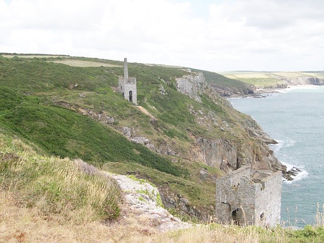
I just had to include this headland in my blog, because it bears the same name as a number of my ancestors; Trewavas is my grandmother’s maiden name. There is also a ruined mine at this location called Wheal Trewavas, one of many such mines dotted along the Cornish coast, which, in their ruined state and romantic clifftop locations, provide one of the most evocative images of this part of the British coast. In fact, the whole mining landscape of Cornwall and West Devon is listed as a World Heritage Site. Cornwall is most famous for its tin mines, but this particular mine was a copper mine. It was only open for 12 years, from 1834 to 1846, but during that time it produced over £100,000-worth of copper ore. There is another mine nearby called Wheal Prosper, which produced copper and tin. The shafts from these clifftop Cornish mines often went some distance out under the sea bed. Anyone wanting to visit them should exercise caution. However tempting it may be to clamber over the remaining brickwork, there are often hidden dangers. In the case of Trewavas, the National Trust recently stepped in and carried out extensive work to repair and protect the mine.

Map of the area.

File:Trewavas Mine - geograph.org.uk - 31494.jpg
Trewavas Mine - geograph.org.uk - 31494. Photo by Tony Atkin, via Wikimedia Commons.


Monday, 17 January 2011

PRAA SANDS

There has been a holiday park at Praa Sands ever since I can remember. In fact, one of my overriding memories of this place from weekend visits to the beach with my parents is of a sea of caravans. It is no surprise that it is such a popular spot, being blessed with a sweeping arc of golden sand.

There is not a lot more to be said about Praa Sands itself. However, nearby there is a strange little castle called Pengersick Castle which has earned a reputation as one of the most haunted in the country. In fact, it appeared in the Most Haunted TV series a few years back. There have been sightings of the ghosts of sailors and monks in the woods around the castle, who may have fallen prey to the violent urges of Henry Pengersick whose victims are thought to have included a monk. This was in the 12th century, but the history of this spot is believed to date right back to the bronze age. For those with a strong constitution, the castle sometimes arranges ghosthunting events.

Map of the area.

File:The beach at Praa Sands - geograph.org.uk - 985687.jpg
The beach at Praa Sands - geograph.org.uk - 985687. Photo by Rod Allday, via Wikimedia Commons.


Sunday, 16 January 2011

PERRANUTHNOE

There are two subjects which I have not yet touched on in my journey around the British coast, but which are particularly relevant to Cornwall: the plethora of shipwrecks off the coast, and the bravery of the local lifeboat men sent to deal with the aftermath of ships coming to grief off these treacherous waters. Cornwall has played host over the years to so many shipwrecks that a map of Cornwall has been produced, with the shipwrecks covering almost every inch of the coastline. As to the lifeboat crews, one can only look on in awe at the bravery of these men who voluntarily risk their lives to save others who stray into their territory and get into difficulties, accidentally or otherwise. On a bad day, lives are lost not only among the ship needing help, but among the lifeboat men themselves. One of the most tragic examples of such an event was immortalised by Seth Lakeman in his song Soloman Browne, about the Penlee lifeboat tragedy of 1981 in which all hands died, both on the stricken vessel, the Union Star, and the Solomon Browne, the lifeboat sent to its rescue. On a good day, both resuers and rescued get off lightly.

This was the case in 1911, when the Norwegian barque Saluto, on its way to Barbados, got into difficulties off the Isles of Scilly. The Captain wisely decided to head for Falmouth, but on the way there came to grief off Cudden Point near Perranuthnoe. However, help was at hand in the form of the Newlyn lifeboat Elizabeth and Blanche, which carried out the rescue with such military precision that the operation was completed in an hour and a half, watched by an appreciative crowd of onlookers.

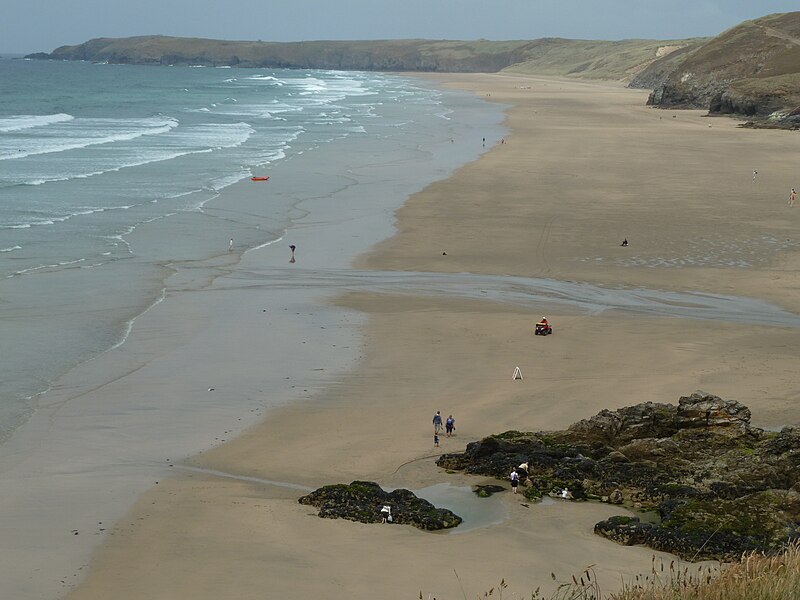
Today, Perranuthnoe is a relatively unspoilt spot on the Cornish coast, affording a view of St Michaels Mount from a different angle from the well-worn one used in tourist promotions. The area around the village is fascinating to students of prehistory. The names of the fields surrounding the village suggest Bronze Age and Roman settlement.  Visitors to the lovely sheltered beach, otherwise known as Perran Sands, which is listed among the top 10 surfing beaches in Cornwall, should check the tide tables, as there is not much of it at high tide.

Live streaming webcam view of Perran.

Map of the area.


File:View of Perran Sands.jpg
View of Perran Sands. Photo by Worm That Turned, via Wikimedia Commons.


Saturday, 15 January 2011

MARAZION

Marazion, which claims to be the oldest town in Britain, having been settled as early as 308BC, is famous above all not for something in the town itself, but for something just offshore. St Michael's Mount is probably one of the most used images in Cornish tourist promotions. It would be unique were it not for its upstart gallic cousin on the other side of the English channel. The Mount is linked to the mainland via a narrow causeway which disappears underwater at high tide, adding a frisson to any visit as people race to get back across without getting their feet, or other body parts, wet. But for those who don’t make it on time all is not lost because there are boats standing by to ferry people back and forth.

There are legends and mysteries galore associated with this spot. In 495AD an apparition of St Michael allegedly appeared before a fisherman, an event which led to the Mount becoming a magnet for pilgrims, who came from all over the country and continued to do so for 1,500 years. Meanwhile, a small rock just offshore, where I used to play on family visits to the beach as a child, was allegedly the product of a marital bustup between the giant Cormoran, who according to legend built St Michael’s Mount, and his wife, who dropped the smaller rock on being given a kicking by her husband.

Map of the area.

Live streaming webcam view of St Michael's Mount.

File:Coastline at Marazion - geograph.org.uk - 218911.jpg
Coastline at Marazion - geograph.org.uk - 218911. Photo by Pam Brophy, via Wikimedia Commons.

Friday, 14 January 2011

PENZANCE

One of the best-known characters from history with a connection to Penzance was Sir Walter Raleigh. He reportedly sat as member for Penzance in the last Parliament under the reign of Queen Elizabeth I. It is widely reported – though not corroborated – that, having discovered the dubious delights of tobacco after estalishing a colony in Virginia in 1584, Sir Walter headed to the Dolphin Inn on Penzance harbourside for a pint, and while there performed the first known act of smoking in an English pub. So, next time you find yourself walking along your local high street, dodging the clouds of smoke billowing through the air courtesy of the forlorn knots of smokers standing outside its hostelries, just remember: it’s all Sir Walter’s fault.

Today, my home town of Penzance is a popular tourist town, not quite as photogenic as its near neighbour St Ives, but rapidly acquiring an air of sophistication through the opening of a number of smart new restaurants, as well as galleries such as the Cornwall Contemporary and The Exchange.  A more established gallery, inside the grounds of Penlee Park, is Penlee House Gallery and Museum. The oldest street in Penzance is Chapel Street, with a number of interesting buildings, most notably the Egyptian House, which is now owned by the Landmark Trust and has been turned into holiday apartments. Down on the seafront is the Promenade, which is routinely battered by waves during rough weather - check out the link to the webcam below on stormy days to see what I mean.  I have fond memories of walking, or running, along the prom with my friends with the waves crashing over, seeing who could come out the other end the driest.  Also on the seafront is the Jubilee Pool, a magnificent example of the 1930s lido, where I also spent many a happy afternoon as a child.  The lido has recently undergone an extensive refurbishment following storm damage, and there has been talk of turning it into a heated pool using geothermal energy.

The absolute must-do event of the year in Penzance in my opinion is the annual Golowan Festival, which takes place in the latter part of June. This incredibly diverse and colourful celebration of all things Celtic is at times more reminiscent of a Latin carnival, especially at its climax, on Mazey Day, when the town comes alive with processions of people of all ages wearing different costumes, and larger-than-life figures such as insects and fantastical creatures, while all over the town colourful flags and banners flutter in the sea breeze. Meanwhile, a programme of live music events, some free, some not, takes place in a marquee near the harbour. For more events in Penzance and surrounding area, see here.

The Harbour

The Promenade, looking towards Newlyn


Live streaming ebcam view of the Promenade.

Map of the area.


Thursday, 13 January 2011

NEWLYN

Many places in Cornwall have provided inspiration for artists over the years, but Newlyn gave rise to a whole artistic movement: the Newlyn School. The founder of the Newlyn School, Stanhope Alexander Forbes, painted some memorable works depicting the fishing industry for which Newlyn is still known: Fish Sale on a Cornish Beach, Safe Anchorage, to name but two. However, I can claim a small personal connection to one of his works – The Health of the Bride – for I am reliably informed that a little old lady who posed as one of the characters in the picture was a relative of mine.  The Newlyn Art Gallery occupies a position alongside the shore and holds regular exhibitions and events.

My own fondest memory of Newlyn is of visiting a small, unassuming sweet shop on the main road into the village which sold – and happily still does – the most wondrous ice cream, Jelberts Ices. There was only one variety, but it had the most divine creamy colour and taste, made even better with a dollop of Cornish clotted cream on top, plus a Flake for the really indulgent.  As for fish, Newlyn is a major fishing port with one of the largest fishing fleets in the country, and its market holds lively auctions attended by local restaurateurs and fishmongers.

Live streaming webcam view of the harbour.

Map of the area.

File:Fishing boats and lifeboat in Newlyn harbour (7339).jpg
Fishing boats and lifeboat in Newlyn harbour (7339). Photo by Nilfanion, via Wikimedia Commons.


Wednesday, 12 January 2011

MOUSEHOLE

Mousehole (or Muzzle as the locals call it) is a place close to my heart – or rather my genes, because many of my ancestors were from this charming little fishing village. My mother grew up in a harbourside cottage literally feet from the harbour’s edge, the sort of place which would fetch a King’s ransom in holiday rentals today. I often wonder what it must have been like to grow up in a place like that, it must have been every child’s dream. The family did not own the cottage, my grandfather being a fisherman of modest means - it was rented. As a sign of the times, that very cottage not so long ago was featured in the Telegraph as property of the week. In fact, Mousehole ranks among the half dozen locations in Cornwall with the highest number of second homes. A far cry from the close-knit local community my mother grew up in.

Going back in time, Mousehole's darkest hour in history came in 1595, when four Spanish galleons from the Spanish Armada landed at Mousehole, and their occupants ran amok and all but burned the village to the ground.  An equally dark time in modern times occurred on 19th December 1981 when eight incredibly brave lifeboat men from the Solomon Browne lifeboat, based at nearby Penlee Point, died trying to rescue the crew of the Union Star coaster.  I spent Christmas with my family in nearby Penzance that year, and I still remember the sombre mood hanging over the whole area following this awful tragedy.

One of the nicest times of year to visit Mousehole is after dark at Christmas, when the harbour is adorned with festive lights. I still remember the lovely Christmassy feeling I used to get as a child when I was taken to see the Muzzle lights, and hear Christmas carols being sung by the harbourside. Just before Christmas, on the eve of Christmas Eve, is Tom Bawcocks’s Eve, named after a resident who saved the village from a famine. This event spawned an unusual culinary delicacy, not for the faint-hearted, called Stargazy Pie, a pilchard pie which has the heads of the pilchards poking out through the pastry. I can’t say I’ve tried it myself; I would be interested to hear from anyone who has!

Live streaming webcam of the harbor.

Map of the area.


File:Mousehole from west.JPG
Mousehole from west. Photo by N p holmes, via Wikimedia Commons.

Tuesday, 11 January 2011

LAMORNA

It takes a special place to inspire a person to change their name to that placename. The painter Samuel John Birch was so captivated by this small cove in West Cornwall that he changed his name to Lamorna Birch. He was one of a number of artists associated with the Newlyn School who settled here around the turn of the last century. With such an artistic pedigree, Lamorna is the perfect place for arts events. The Lamorna Valley Group holds regular exhibitions and other events.

My own memories of Lamorna are centered around the Easter festivities. When I was growing up in West Cornwall, my friends and I used to take part in the annual Good Friday walk from Penzance to Lamorna. There was a suitably religious background to this walk, the distance – 5 miles – being roughly equivalent to the distance covered by Jesus on his way to the cross. However, our conduct on the walk was often less than religious, full of teenage high jinx.

There is a famous Cornish song featuring Lamorna. Here is the first verse:

So now I'll sing to you, it's about a maiden fair
I met the other evening at the corner of the square;
She'd a dark and roving eye, and her hair hung to her shoulder,
We rolled all night in the pale moonlight away down to Lamorna

Map of the area.


                      Lamorna Cove Cornwall 3. Photo by Tom Corser, via Wikimedia Commons.

Monday, 10 January 2011

PENBERTH

The next little cove around the coast from Porthcurno is Penberth Cove. This beautiful little place, hidden away at the end of a secluded valley, has a timeless feel about it, and fishing boats still leave from the tiny slipway to fish for mackerel, lobster and crab, as they have done for as far back as anyone can remember. The only concession to modern life is that an electric winch is now used to haul the boats back up from the sea.

When my mother was still fit enough to do cliff walking, Penberth was one of her favourite launchpads for a walk along the South-West coastal path, which can be accessed in either direction from the hamlet here. The path climbs up through thick vegetation, then winds its way around the rocky clifftops, from where the sea can be heard roaring and crashing against the rocks below.

Map of the area.

Penberth, by Barbara Ashley


Sunday, 9 January 2011

PORTHCURNO

Looking out over the beautiful beach at Porthcurno with its pale sand and turquoise waters more reminiscent of the Caribbean than Blighty, the last thing which comes to mind is war. However, during World War II Porthcurno played a vital role, or rather the Cornish miners did, who built a number of bombproof tunnels, which permitted the laying of 14 secure cables connecting the UK with its allies. This fascinating story is told in the Porthcurno Telegraph Museum. Today, Porthcurno is most famous for its magnificently situated Minack Theatre, an amphitheatre clinging to the cliff face, built by the remarkable Rowena Cade, who, wanting to stage dramatic performances in her garden, but lacking the necessary space, in the 1930s set about creating what has come to be known as one of the most unusual theatres in the world. Today, the theatre hosts a range of events from classic Shakespeare productions such as The Tempest, for which this is the perfect setting, to concerts by artists such as the West Country folk artist Seth Lakeman, whose songs include many with a seafaring theme, and whose concert at the Minack is available as a DVD.

A short distance along the coast from Porthcurno is a most unusual geological phenomenon known as Logan Rock, a large boulder which, due to years of erosion at the hands of the weather, ended up balancing precariously on the clifftop. This piece of geological eccentricity was the victim of an inexplicable act of vandalism in 1824 when a Royal Navy lieutenant called Lt. Goldsmith, who was visiting the area in order to attach a warning buoy to a nearby reef, decided it would be rather fun to head across to Logan Rock and dislodge it from its perch. After deafening howls of protest from the locals at this heinous act, the rock was eventually replaced later that year, an operation requiring the combined efforts of over 60 men.

Webcam view from the Minack.

Map of the area.

File:Minack Theatre und Bucht - panoramio.jpg
Minack Theatre und Bucht - panoramio. Photo by Jürgen Regel, Marian…, via Wikimedia Commons.


Saturday, 8 January 2011

PORTHGWARRA

The first place that can be remotely described as a settlement, following the coast around from Lands End, is the tiny hamlet of Porthgwarra, with its lilliputian slipway and beach. Probably one of the most interesting features of this spot is the pair of tunnels carved through the rock. Some of the more fanciful theories about these tunnels involve smugglers, but in truth they were intended for use by the local farmers and fishermen; one of them dug by tin miners to give farmers access to the beach so that they could gather seaweed to use as fertiliser, and the other used by fishermen to reach their ‘hulleys’, or shellfish stores built into the rocks.

Porthgwarra is a haven for birdwatchers, with recorded sightings including choughs, yellow-browed and dusky warblers, stonechat, linnet, wheatear, snow bunting, and even black-browed albatross. Nearby Gwennap Head plays host to shearwaters, skuas, petrels and whimbrels, with a colony of gannets nearby. Meanwhile, basking sharks can sometimes be seen out to sea, while for those looking for the ‘aah’ factor, there are grey seals to be seen on the rocks below the cliffs.

Webcam view.

Map of the area.


File:View towards Garrack Roberts, Porthgwarra - geograph.org.uk - 933619.jpg
View towards Garrack Roberts, Porthgwarra - geograph.org.uk - 933619. Photo by Jim Champion, via Wikimedia Commons.


LANDS END

I didn’t want to start my blog with a negative entry, but I felt compelled to vent my spleen about Lands End, so here goes. If you want an example of what not to do with a wild and beautiful corner of the country, you need look no further than Lands End. When I was growing up in West Cornwall, Lands End was a relatively unspoilt headland, with a hotel, gift shop, the famous signpost with signs pointing to far flung places all over the world which proved a magnet for people wanting their photo taken as a memento of their visit – and not a lot else. Lands End sunsets are legendary, and a local bus company used to run evening tours out there with the sole purpose of taking people to see the awesome spectacle. The day we went the weather was perfect. I don’t know what happened if the weather failed to cooperate – did people get their money back?

Fast forward to the 21st century, and this amazing promontory has been turned into a themepark, completely out of character with this lovely spot. The signpost is still there, but rather than just park up and wander down to it like we used to do, you now have to pay to park before you can get anywhere near it, and when you get there you have to pay to have your picture taken! I suppose there are some people, particularly those with children, who would find the various 'attractions' a welcome diversion, but I would much rather this magnificent headland had been left as it was. Oh well, you can’t turn back the clock, and there are plenty of other unspoilt beauty spots along the Cornish coast, many of which will feature in this blog.

Map of the area.


File:Land's End - panoramio (1).jpg
Land's End - panoramico (1). Photo by giomodica, via Wikimedia Commons.